

Wandelkaart 190 - Malvern Hills AONB & Bredon Hill - OSI
De nederzettingen van de Great Malvern & Upton op Severn


Korte omschrijving
Wandelkaarten Worcestershire, West England van Ordnance Survey. Ideaal voor tochten in England.
Wandelkaart Malvern Hills AONB & Bredon Hill AONB England Omvat ook: Tewkesbury, Ledbury, Pershore & Upton upon Severn. Productbeschrijving: Kaart nummer 190 in de OS Explorer kaarten re...

Specificaties
- Uitgever: Ordnance Survey
- ISBN-13: 9780319470626
- HOOFDCATEGORIEËN: Wandelkaart
- Activiteiten: Wandelen, Hiking & Trekking
- Regio: Worcestershire, West England
- Land: England
- Waterafstotende kaart: Ordnance Survey ACTIVE Explorer Weatherproof Maps
- TOPO's & Stafkaarten: Topografisch wandelen
- AONB - Area of Outstanding Beauty/National Landscape: Cotswolds AONB, Malvern Hills AONB
- Schaal: 1:25000
- Taal: Engels
- Reeks/Serie: Explorer ACTIVE Series OSI
Volledige omschrijving
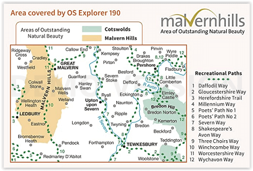
Wandelkaart Malvern Hills AONB & Bredon Hill AONB England
Omvat ook: Tewkesbury, Ledbury, Pershore & Upton upon Severn.
Productbeschrijving: Kaart nummer 190 in de OS Explorer kaarten reeks heeft betrekking op twee gebieden van uitzonderlijke natuurlijke schoonheid; de Cotswolds AONB en het bestuurlijke gebied Malvern Hills AONB en de nederzettingen van de Great Malvern, Upton op Severn, Ledbury, Pershore en Tewkesbury. Bevat ook secties van de rivier de Severn en de rivier de Avon en Bredon Hill. De OS Explorer kaart voor bestuurlijke gebied Malvern Hills & Bredon Hill is beschikbaar in zowel de standaard papieren versie als de weerbestendige 'Actief' versie.
Productdiscription: Map sheet number 190 in the OS Explorer series covers two areas of Outstanding Natural Beauty; the Cotswolds AONB and the Malvern Hills AONB and the settlements of Great Malvern, Upton upon Severn, Ledbury, Pershore and Tewkesbury. Also includes sections of the River Severn and the River Avon and Bredon Hill. The OS Explorer map for Malvern Hills & Bredon Hill is available in both the standard paper version and weatherproof 'Active' version.
Locatie op kaart
Gekoppelde artikelen

Wandelkaart 190 Malvern Hills AONB & Bredon Hill - OSI • 9780319243831
standaard versieWandelkaart Malvern Hills & Bredon Hill - Herefordshire Omvat ook: Tewkesbury, Ledbury, Pershore & Upton upon Severn Productomschrijving: Kaart nummer 190 in de OS Explorer kaarten reeks heeft betrekking op twee AONB gebieden van uitzonderlijke natuurlijke schoonheid: de Cotswolds AONB, de Malvern Hills en de nederzettingen van de Great Malvern, Upton op Severn, Ledbury, Pershore en Te…

Wandelkaart 190 - Malvern Hills AONB & Bredon Hill - OSI • 9780319470626
weatherproof versieWandelkaart Malvern Hills AONB & Bredon Hill AONB England Omvat ook: Tewkesbury, Ledbury, Pershore & Upton upon Severn. Productbeschrijving: Kaart nummer 190 in de OS Explorer kaarten reeks heeft betrekking op twee gebieden van uitzonderlijke natuurlijke schoonheid; de Cotswolds AONB en het bestuurlijke gebied Malvern Hills AONB en de nederzettingen van de Great Malvern, Upton op Sever…
Overzichtskaarten

Area's of Outstanding Natural Beauty - AONB's UK
Area's of Outstanding Natural Beauty - AONB's UK

Producten op de overzichtskaart
Klik op een product om naar de detailpagina te gaan.
- Wandelgids - Guide to the Cotswolds AONB - AA
- Wandelkaart 24 - Chilterns AONB - AA
- Wandelgids - Cotswold classic walks guidebook - Goldeneye
- Wandelgids - Cotswold Classic Walks - Goldeneye
- Wandelgids - The Cotswold Way 30 classic routes - Cicerone
- Wandelgids - North Downs Way Nat. trail - Cicerone
- Wandelgids - Chilterns walking guide - Cicerone
- Wandelgids - Suffolk coast & Heaths walks - Cicerone
- Wandelgids - North Downs Way - Map Booklet - Cicerone
- Wandelgids - North Pennines AONB walking guide - Cicerone
- Wandelgids - Forest of Bowland & Pendle - Cicerone
- Wandelgids - Hampshire's Test Way walking guide - Cicerone
- Wandelgids & Fietsgids - The Cotswold AONB - Cicerone
- Wandelgids - North Wessex Downs - Cicerone Press
- Wandelgids - Walking on the North Wessex Downs - Cicerone
- Wandelgids - Silverdale & Arnside AONB - Cicerone
- Wandelkaart OL2 - Yorkshire Dales- Southern & Western Areas - OSI
- Wandelkaart OL19 - Howgill Fells and Upper Eden Valley - OSI
- Wandelkaart OL21 - South Pennines - Yorkshire - OSI
- Wandelkaart OL31 - North Pennines- Teesdale & Weardale - OSI
- Wandelkaart OL40 - The Broads - OSI
- Wandelkaart OL41 - Forest of Bowland & Ribblesdale - OSI
- Wandelkaart OL45 - The Cotswolds AONB- Gloucestershire - OSI
- Wandelkaart 108 - Lower Tamer Valley & Plymouth- Cornwall- OSI
- Wandelkaart 115 - Exmouth & Sidmouth- Devon - OSI
- Wandelkaart 137 - Ashford- Kent downs AONB- England - OSI
- Wandelkaart 140 - Quantock Hills AONB- Somerset - OSI
- Wandelkaart 140 - Quantock Hills AONB & Bridgwater- Devon - OSI
- Wandelkaart 147 - Sevenoaks & Tonbridge- Kent - OSI
- Wandelkaart 164 - Gower AONB & Gwyr- South Wales - OSI
- Wandelkaart 164 - Gower AONB & Gwyr- Wales - OSI
- Wandelkaart 171 - Chiltern Hills West & Henley-on-Thames OSI
- Wandelkaart 171 - Chiltern Hills West AONB- Wycombe - OSI
- Wandelkaart 172 - Chiltern Hills East AONB- Wycombe - OSI
- Wandelkaart 181 - Chiltern Hills AONB North- England - OSI
- Wandelkaart 181 - Chiltern Hills North AONB- Wycombe - OSI
- Wandelkaart 190 - Malvern Hills & Bredon Hill - OSI
- Wandelkaart 190 - Malvern Hills AONB & Bredon Hill - OSI
- Wandelkaart 203 - Ludlow- Shropshire Hills AONB - OSI
- Wandelkaart 217 - Long Mynd & Wenlock Edge- Schropshire- OSI
- Wandelkaart 254 - Lleyn Peninsular East- North Wales - OSI
- Wandelkaart 261 - Boston- Lincolnshire AONB - OSI
- Wandelkaart 262 - Anglesey West- Wales AONB - OSI
- Wandelkaart 263 - Anglesey East AONB- Wales - OSI
- Wandelkaart 273 - Lincolnshire Wolds South AONB - OSI
- Wandelkaart 282 - Lincolnshire Wolds North AONB - OSI
- Wandelkaart 298 - Nidderdale AONB- Yorkshire - OSI
- Wandelkaart 298 - Nidderdale AONB North Yorkshire - OSI
- Wandelkaart 300 - Howardian Hills AONB - OSI
- Wandelkaart 300 - Howardian Hills AONB & Malton - OSI
- Wandelkaart - Mourne Mountains N. Ireland - Harvey maps
- Wandelkaart - Fietskaart Forest of Bowland - Harvey maps
- Wandelkaart XT40 - Anglesey Coastal Path N. Wales - Harvey Maps
- Wandelkaart XT40 - Pennine Way Noord - Harvey Maps
- Wandelkaart XT40 - Pennine Way Zuid - Harvey Maps
- Wandelgids Cotswold - Way Two-way trekking guide - Knife Edge
- Reisgids Cotswolds England - Rough Guides
Artikelen uit dezelfde regio

Moutainbike Cotswold Gravel & Mountain AONB - Goldeneye • 9781859653135
Moutainbike map Cotswold - Goldeneye Productomschrijving: Cotswold Gravel & Mountain Bike Routes: The Ultimate Off-Road Experience - Gravel & Mountain Bike Routes 18 (Paperback) When mountainbiking in the Cotswolds, in an Area of Outstanding Natural Beauty of AONB area, a lot of sportsfanatics & MTB fanatics are very interested, and cannot go wrong with this new Goldeneye mountainbiki…

Reisgids Cotswolds + Oxford & Stratford-Uppon-Avon - Rough Guides • 9781835295168
Cotswolds + Oxford & Stratford-Uppon-Avon - Rough Guides Productomschrijving: The Rough Guide to the Cotswolds is your definitive handbook to one of the most beautiful and diverse holiday destinations in the UK. From stately homes and wildlife parks to modern art galleries, country walks and adventure sports, there is a section that introduces all of the regions’ highlights. For every…
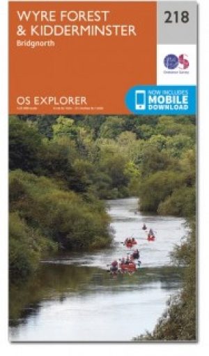
Wandelkaart 218 Kidderminster & Wyre Forest - OSI • 9780319470909
Wandelkaart Kidderminster & Wyre Forest - Worcestershire Omvat ook: Bridgnorth. Productbeschrijving: OS Explorer kaart 218 volgt het zuiden van de rivier de Severn van Stockton naar Stourport-on-Severn. Het toont een aantal Recereational paden, met inbegrip van Jack Mytton Way, Severn way en de Staffordshire way. De OS Explorer kaart voor Kidderminster & Wyre Forest is beschikbaar in z…

Wandelkaart OL45 The Cotswolds AONB - OS • 9780319242841
Wandelkaart The Cotswolds AONB - OS Productomschrijving: Wychwood Community Forest, The Centenary Way, Cotswolds Way, D'Arcy Dalton Way, Diamond Way, E2 European Long Distance Path, Gloucestershire Way, Heart of England Way, Macmillan Way, Monarch's Way, Oxfordshire Way, Thames Path, Shakespeare Way, Warden's Way, Winchcombe Way, Windrush Way & Wychavon Way. Omvat: Burford, Chipping C…

Wandelkaart 138 Kidderminster & Wyre Forest - OSI • 9780319474617
Wandelkaart Kidderminster & Wyre Forest - Worcestershire England Productbeschrijving: OS Landranger kaart 138 van Kidderminster & Wyre Forest omvat ook Bridgnorth, Abdon Stanton Lacy, Bayton, Stoke Bliss, Brimfield, Ludlow, Highley, Six Ashes, Chetton en Much Wenlock. De OS Landranger kaarten reeks heeft betrekking op Groot-Brittannië met 204 gedetailleerde kaarten, perfect voor dagtochten…