

Wandelkaart OL40 - The Broads - OSI
The Broads National Park

Korte omschrijving
Wandelkaarten Norfolk East England en Suffolk East Anglia van Ordnance Survey. Ideaal voor tochten in England.
Wandelkaart The Broads National Park - OSI Productomschrijving: Kaart OL40 in de OS Explorer serie bestrijkt The Broads, een lid van de familie van nationale parken. De rivieren zijn de Bure...

Specificaties
- Uitgever: Ordnance Survey
- ISBN-13: 9780319475485
- HOOFDCATEGORIEËN: Wandelkaart
- Activiteiten: Wandelen, Hiking & Trekking
- Regio: Norfolk East England, Suffolk East Anglia
- Land: England
- Waterafstotende kaart: Ordnance Survey ACTIVE Explorer Weatherproof Maps
- Nationale parken: Broads National Park, England
- TOPO's & Stafkaarten: Topografisch wandelen
- AONB - Area of Outstanding Beauty/National Landscape: Norfolk Coast AONB
- Schaal: 1:25000
- Taal: Engels
- Reeks/Serie: Explorer ACTIVE Series OSI
- De Nationale Parken: The Broads National Park, England
Volledige omschrijving
Wandelkaart The Broads National Park - OSI
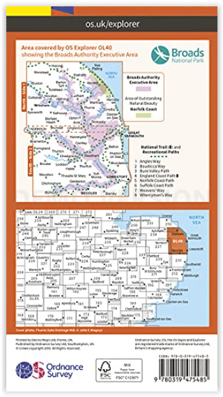
Productomschrijving: Kaart OL40 in de OS Explorer serie bestrijkt The Broads, een lid van de familie van nationale parken. De rivieren zijn de Bure, Ant, Thurne, Yare, Chet en Waveney. De kaart toont ook de kusten van Norfolk en Suffolk en de badplaatsen Great Yarmouth en Lowestoft. Een ander hoogtepunt van het gebied is de stad Norwich.
Inclusief mobiele downloadBij deze kaart ontvangt u een code voor gebruik op uw iOS- of Android-smartphone of -tablet. Meer informatie vindt u bij Veelgestelde vragen over mobiel downloaden.
Nationale wandelroutes:
- Angles Way - Boucicca Way - Bure Valley Path - England Coast Path - Norfolk Coast PAth - Suffolk Coast Path - Weaver's Way - Wherryman's Way
Engelse omschrijving: Map sheet OL40 in the OS Explorer series covers the Broads, a member of the national park family. Its rivers are the Bure, Ant, Thurne, Yare, Chet and Waveney. The map also shows the Norfolk and Suffolk coasts and the seaside towns of Great Yarmouth and Lowestoft. Another highlight of the area is the city of Norwich.
Includes mobile downloadWith this map you will receive a code for use on your iOS or Android smartphone or tablet. Find our more at Mobile Download FAQ.
.png)
Locatie op kaart
Overzichtskaarten

Area's of Outstanding Natural Beauty - AONB's UK
Area's of Outstanding Natural Beauty - AONB's UK

Producten op de overzichtskaart
Klik op een product om naar de detailpagina te gaan.
- Wandelgids - Guide to the Cotswolds AONB - AA
- Wandelkaart 24 - Chilterns AONB - AA
- Wandelgids - Cotswold classic walks guidebook - Goldeneye
- Wandelgids - Cotswold Classic Walks - Goldeneye
- Wandelgids - The Cotswold Way 30 classic routes - Cicerone
- Wandelgids - North Downs Way Nat. trail - Cicerone
- Wandelgids - Chilterns walking guide - Cicerone
- Wandelgids - Suffolk coast & Heaths walks - Cicerone
- Wandelgids - North Downs Way - Map Booklet - Cicerone
- Wandelgids - North Pennines AONB walking guide - Cicerone
- Wandelgids - Forest of Bowland & Pendle - Cicerone
- Wandelgids - Hampshire's Test Way walking guide - Cicerone
- Wandelgids & Fietsgids - The Cotswold AONB - Cicerone
- Wandelgids - North Wessex Downs - Cicerone Press
- Wandelgids - Walking on the North Wessex Downs - Cicerone
- Wandelgids - Silverdale & Arnside AONB - Cicerone
- Wandelkaart OL2 - Yorkshire Dales- Southern & Western Areas - OSI
- Wandelkaart OL19 - Howgill Fells and Upper Eden Valley - OSI
- Wandelkaart OL21 - South Pennines - Yorkshire - OSI
- Wandelkaart OL31 - North Pennines- Teesdale & Weardale - OSI
- Wandelkaart OL40 - The Broads - OSI
- Wandelkaart OL41 - Forest of Bowland & Ribblesdale - OSI
- Wandelkaart OL45 - The Cotswolds AONB- Gloucestershire - OSI
- Wandelkaart 108 - Lower Tamer Valley & Plymouth- Cornwall- OSI
- Wandelkaart 115 - Exmouth & Sidmouth- Devon - OSI
- Wandelkaart 137 - Ashford- Kent downs AONB- England - OSI
- Wandelkaart 140 - Quantock Hills AONB- Somerset - OSI
- Wandelkaart 140 - Quantock Hills AONB & Bridgwater- Devon - OSI
- Wandelkaart 147 - Sevenoaks & Tonbridge- Kent - OSI
- Wandelkaart 164 - Gower AONB & Gwyr- South Wales - OSI
- Wandelkaart 164 - Gower AONB & Gwyr- Wales - OSI
- Wandelkaart 171 - Chiltern Hills West & Henley-on-Thames OSI
- Wandelkaart 171 - Chiltern Hills West AONB- Wycombe - OSI
- Wandelkaart 172 - Chiltern Hills East AONB- Wycombe - OSI
- Wandelkaart 181 - Chiltern Hills AONB North- England - OSI
- Wandelkaart 181 - Chiltern Hills North AONB- Wycombe - OSI
- Wandelkaart 190 - Malvern Hills & Bredon Hill - OSI
- Wandelkaart 190 - Malvern Hills AONB & Bredon Hill - OSI
- Wandelkaart 203 - Ludlow- Shropshire Hills AONB - OSI
- Wandelkaart 217 - Long Mynd & Wenlock Edge- Schropshire- OSI
- Wandelkaart 254 - Lleyn Peninsular East- North Wales - OSI
- Wandelkaart 261 - Boston- Lincolnshire AONB - OSI
- Wandelkaart 262 - Anglesey West- Wales AONB - OSI
- Wandelkaart 263 - Anglesey East AONB- Wales - OSI
- Wandelkaart 273 - Lincolnshire Wolds South AONB - OSI
- Wandelkaart 282 - Lincolnshire Wolds North AONB - OSI
- Wandelkaart 298 - Nidderdale AONB- Yorkshire - OSI
- Wandelkaart 298 - Nidderdale AONB North Yorkshire - OSI
- Wandelkaart 300 - Howardian Hills AONB - OSI
- Wandelkaart 300 - Howardian Hills AONB & Malton - OSI
- Wandelkaart - Mourne Mountains N. Ireland - Harvey maps
- Wandelkaart - Fietskaart Forest of Bowland - Harvey maps
- Wandelkaart XT40 - Anglesey Coastal Path N. Wales - Harvey Maps
- Wandelkaart XT40 - Pennine Way Noord - Harvey Maps
- Wandelkaart XT40 - Pennine Way Zuid - Harvey Maps
- Wandelgids Cotswold - Way Two-way trekking guide - Knife Edge
- Reisgids Cotswolds England - Rough Guides
Artikelen uit dezelfde regio
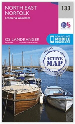
Wandelkaart 133 North East Norfolk - Cromer - Wroxham - OSI • 9780319475508
North East Norfolk- Cromer & Wroxham - OSI Productomschrijving: Kaart nummer 133 in de OS Landranger kaartenserie bestrijkt het noordoosten van Norfolk, Cromer, Holt, North Walsham, Aylsham, Sherringham en Wroxham en omvat Barton Broad en het zuidelijkste deel van de Peddars Way & Norfolk Coast Path. De kaart bestrijkt een gebied van 40 km bij 40 km (25 mijl bij 25 mijl). Engelse omsch…
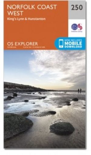
Wandelkaart 250 Norfolk Coast West England - OSI • 9780319471227
Wandelkaart Norfolk Coast West - Norfolk England Omvat ook: King’s Lynn & Hunstanton. Productbeschrijving: Kaart nummer 250 in de OS Explorer kaarten reeks behandelt de noordkust west Norfolk en een paar van de binnelandse gebieden, met inbegrip van de steden van Hunstanton en King's Lynn, en kleinere nederzettingen zoals Holme-next-the-Sea, Burnham Deepdale en Woflington. Hoogtepunten…
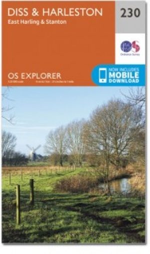
Wandelkaart 230 Diss- Harleston & East Harling - OSI • 9780319244234
Wandelkaart Diss- Harleston- East Harling - Suffolk England Productbeschrijving: - East Harling & Stanton. 230 / Diss, Harleston, East Harling, Suffolk, England - Na de rivier Waveney is deze OS Explorer kaart 230 een ' double-sided map, die East Harling, Diss en Harleston omvat. Hoogtepunten van het gebied vormen deel van de Norfolk kust pad National Trail, Footpath, Hereward way, Ped…

Wandelgids Norfolk Coast Path & Peddars Way - Trailblazer • 9781912716395
Norfolk Coast Path & Peddars Way - Trailblazer Productomschrijving: De Peddars Way loopt door East Anglia vanaf Knettishall Heath op de grens van Norfolk en Suffolk en volgt een Romeinse weg naar Holme-next-the-Sea. Van hieruit wordt het het Norfolk Coast Path, dat de prachtige kustlijn van Norfolk volgt via Holkham, Wells, Blakeney en Cley naar Cromer voordat het de schouder van het graaf…

Reisgids Norfolk & Suffolk - Rough Guides • 9781839050749
Norfolk & Suffolk - Rough Guides Productomschrijving: De Rough Guide to Norfolk & Suffolk richt zich op een van de meest populaire regio's van het Verenigd Koninkrijk. In full colour, met tientallen prachtige foto's, zal het u inspireren om dit diverse en prachtige gebied te verkennen. Levendige, onderhoudende verslagen in de kenmerkende eerlijke, openhartige stijl van de Rough Guides…