

Wandelkaart 164 Gower AONB & Gwyr- South Wales - OSI
Het gebied ten westen van Swansea- Llanelli en the Mumbles

Korte omschrijving
Wandelkaarten South Wales van Ordnance Survey. Ideaal voor tochten in Wales.
Wandelkaart Gower AONB & Gwyr - South Wales Omvat ook: Llanelli Productomschrijving: Kaart nummer 164 in de OS Explorer kaarten reeks heeft betrekking op het Gower AONB in Zuid-Wales. De...

Specificaties
- Uitgever: Ordnance Survey
- ISBN-13: 9780319243572
- HOOFDCATEGORIEËN: Wandelkaart
- Activiteiten: Wandelen, Hiking & Trekking
- Regio: South Wales
- Land: Wales
- TOPO's & Stafkaarten: Topografisch wandelen
- AONB - Area of Outstanding Beauty/National Landscape: Gower AONB
- Schaal: 1:25000
- Taal: Engels
- Reeks/Serie: Explorer Series OS
Volledige omschrijving
Wandelkaart Gower AONB & Gwyr - South Wales
Omvat ook: Llanelli
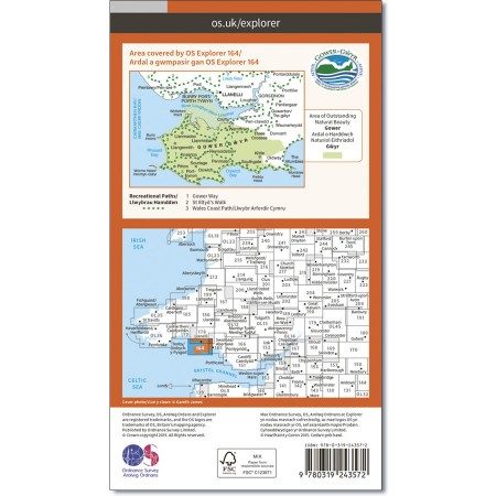
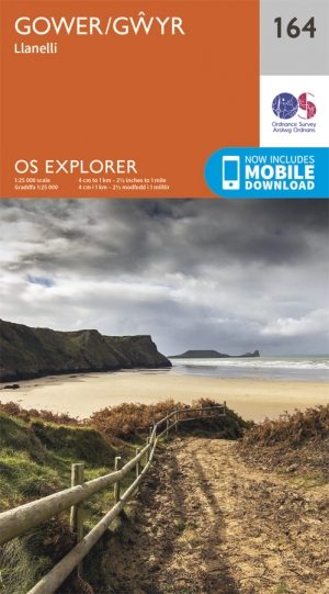
Productomschrijving: Kaart nummer 164 in de OS Explorer kaarten reeks heeft betrekking op het Gower AONB in Zuid-Wales. De Gower way en St Illtyd's way worden weergegeven in het gebied ten westen van Swansea rond Llanelli en the Mumbles. Andere steden in het gebied omvatten: Burry Port, Goresinon en Worms head. De OS Explorer kaart voor Gower is beschikbaar in zowel de standaard papieren versie als de weerbestendige 'Actief' versie.
Kaart nummer 164 is een all purpose kaart vol gepakt met informatie om u het gebied te helpen leren kennen. De kaarten bestrijken het land. Elke kaart heeft een oppervlakte van 40 km door 40 km (25 mijl door 25 mijl) en zoals andere kaarten van Ordnance Survey, National Grid-vierkanten worden verstrekt zodat elke functie een unieke referentienummer kan worden gegeven.
Productdiscription: Map sheet number 164 in the OS Explorer series covers the Gower Area of Outstanding Natural Beauty in South Wales. The Gower Way and St Illtyd's Way are covered in the area to the west of Swansea around Llanelli and the Mumbles. Other towns in the area include: Burry Port, Goresinon and Worms Head. The OS Explorer map for Gower is available in both the standard paper version and weatherproof 'Active' version.
Locatie op kaart
Gekoppelde artikelen
Wandelkaart 164 Gower AONB & Gwyr- South Wales - OSI • 9780319243572
standaard versieWandelkaart Gower AONB & Gwyr - South Wales Omvat ook: Llanelli Productomschrijving: Kaart nummer 164 in de OS Explorer kaarten reeks heeft betrekking op het Gower AONB in Zuid-Wales. De Gower way en St Illtyd's way worden weergegeven in het gebied ten westen van Swansea rond Llanelli en the Mumbles. Andere steden in het gebied omvatten: Burry Port, Goresinon en Worms head. De OS Explo…

Wandelkaart 164 - Gower AONB & Gwyr- Wales - OSI • 9780319470367
weatherproof versieWandelkaart Gower & Gwyr- Carmarthenshire - Wales Productbeschrijving: Kaart nummer 164 in de OS Explorer reeks heeft betrekking op de Gower Area of Outstanding Natural Beauty AONB in Zuid-Wales. De Gowerway en St Illtyd's way worden behandeld in het gebied ten westen van Swansea rond Llanelli en de Mumbles. Andere steden in het gebied omvatten: Burry Port, Goresinon en Worms head. De OS E…
Overzichtskaarten

Area's of Outstanding Natural Beauty - AONB's UK
Area's of Outstanding Natural Beauty - AONB's UK

Producten op de overzichtskaart
Klik op een product om naar de detailpagina te gaan.
- Wandelgids - Guide to the Cotswolds AONB - AA
- Wandelkaart 24 - Chilterns AONB - AA
- Wandelgids - Cotswold classic walks guidebook - Goldeneye
- Wandelgids - Cotswold Classic Walks - Goldeneye
- Wandelgids - The Cotswold Way 30 classic routes - Cicerone
- Wandelgids - North Downs Way Nat. trail - Cicerone
- Wandelgids - Chilterns walking guide - Cicerone
- Wandelgids - Suffolk coast & Heaths walks - Cicerone
- Wandelgids - North Downs Way - Map Booklet - Cicerone
- Wandelgids - North Pennines AONB walking guide - Cicerone
- Wandelgids - Forest of Bowland & Pendle - Cicerone
- Wandelgids - Hampshire's Test Way walking guide - Cicerone
- Wandelgids & Fietsgids - The Cotswold AONB - Cicerone
- Wandelgids - North Wessex Downs - Cicerone Press
- Wandelgids - Walking on the North Wessex Downs - Cicerone
- Wandelgids - Silverdale & Arnside AONB - Cicerone
- Wandelkaart OL2 - Yorkshire Dales- Southern & Western Areas - OSI
- Wandelkaart OL19 - Howgill Fells and Upper Eden Valley - OSI
- Wandelkaart OL21 - South Pennines - Yorkshire - OSI
- Wandelkaart OL31 - North Pennines- Teesdale & Weardale - OSI
- Wandelkaart OL40 - The Broads - OSI
- Wandelkaart OL41 - Forest of Bowland & Ribblesdale - OSI
- Wandelkaart OL45 - The Cotswolds AONB- Gloucestershire - OSI
- Wandelkaart 108 - Lower Tamer Valley & Plymouth- Cornwall- OSI
- Wandelkaart 115 - Exmouth & Sidmouth- Devon - OSI
- Wandelkaart 137 - Ashford- Kent downs AONB- England - OSI
- Wandelkaart 140 - Quantock Hills AONB- Somerset - OSI
- Wandelkaart 140 - Quantock Hills AONB & Bridgwater- Devon - OSI
- Wandelkaart 147 - Sevenoaks & Tonbridge- Kent - OSI
- Wandelkaart 164 - Gower AONB & Gwyr- South Wales - OSI
- Wandelkaart 164 - Gower AONB & Gwyr- Wales - OSI
- Wandelkaart 171 - Chiltern Hills West & Henley-on-Thames OSI
- Wandelkaart 171 - Chiltern Hills West AONB- Wycombe - OSI
- Wandelkaart 172 - Chiltern Hills East AONB- Wycombe - OSI
- Wandelkaart 181 - Chiltern Hills AONB North- England - OSI
- Wandelkaart 181 - Chiltern Hills North AONB- Wycombe - OSI
- Wandelkaart 190 - Malvern Hills & Bredon Hill - OSI
- Wandelkaart 190 - Malvern Hills AONB & Bredon Hill - OSI
- Wandelkaart 203 - Ludlow- Shropshire Hills AONB - OSI
- Wandelkaart 217 - Long Mynd & Wenlock Edge- Schropshire- OSI
- Wandelkaart 254 - Lleyn Peninsular East- North Wales - OSI
- Wandelkaart 261 - Boston- Lincolnshire AONB - OSI
- Wandelkaart 262 - Anglesey West- Wales AONB - OSI
- Wandelkaart 263 - Anglesey East AONB- Wales - OSI
- Wandelkaart 273 - Lincolnshire Wolds South AONB - OSI
- Wandelkaart 282 - Lincolnshire Wolds North AONB - OSI
- Wandelkaart 298 - Nidderdale AONB- Yorkshire - OSI
- Wandelkaart 298 - Nidderdale AONB North Yorkshire - OSI
- Wandelkaart 300 - Howardian Hills AONB - OSI
- Wandelkaart 300 - Howardian Hills AONB & Malton - OSI
- Wandelkaart - Mourne Mountains N. Ireland - Harvey maps
- Wandelkaart - Fietskaart Forest of Bowland - Harvey maps
- Wandelkaart XT40 - Anglesey Coastal Path N. Wales - Harvey Maps
- Wandelkaart XT40 - Pennine Way Noord - Harvey Maps
- Wandelkaart XT40 - Pennine Way Zuid - Harvey Maps
- Wandelgids Cotswold - Way Two-way trekking guide - Knife Edge
- Reisgids Cotswolds England - Rough Guides

OSI Explorer & Explorer Active - Wales
OSI Explorer & Explorer Active - Wales

Producten op de overzichtskaart
Klik op een product om naar de detailpagina te gaan.
- Wandelkaart 151 Cardiff & Bridgend- Wales - OSI
- Wandelkaart 152 Newport & Pontypool- South Wales - OSI
- Wandelkaart 164 Gower AONB & Gwyr- South Wales - OSI
- Wandelkaart 165 Swansea & Abertawe- South Wales - OSI
- Wandelkaart 166 Rhondda & Merthyr Tydfil - OSI
- Wandelkaart 177 Carmarthen & Kidwelly- Wales - OSI
- Wandelkaart 178 Llanelli- Ammanford & Rhydaman - OSI
- Wandelkaart 185 Newcastle & Emly- Northumberland - OSI
- Wandelkaart 186 Llandeilo- Brechfa Forest- Wales - OSI
- Wandelkaart 187 Llandovery- South Wales - OSI
- Wandelkaart 188 Builth Wells & Llanfair-ym-Muallt - OSI
- Wandelkaart 189 Hereford & Ross-on-Wye- England - OSI
- Wandelkaart 198 Cardigan & New Quay- Wales - OSI
- Wandelkaart 199 Lampeter- Wales - OSI
- Wandelkaart 200 Llandrindod Wells & Elan Valley - OSI
- Wandelkaart 201 Knighton & Presteigne- Wales - OSI
- Wandelkaart 202 Leominster & Bromyard Hererfordshire - OSI
- Wandelkaart 203 Ludlow & Shropshire Hills AONB - OSI
- Wandelkaart 213 Aberystwyth & Cwm Rheidol - Wales - OSI
- Wandelkaart 214 Llanidloes- Newtown & Y Drenewydd - OSI
- Wandelkaart 215 Newtown & Machynlleth- Powys Wales - OSI
- Wandelkaart 216 Welshpool & Montgomery- Powys - OSI
- Wandelkaart 217 Long Mynd & Wenlock Edge - OSI
- Wandelkaart 239 Lake Vyrnwy & Efyrnwy- North Wales - OSI
- Wandelkaart 240 Oswestry & Croesoswallt- Shropshir - OSI
- Wandelkaart 241 Shrewsbury- shropshire England - OSI
- Wandelkaart 253 Lleyn Peninsula West Wales - OSI
- Wandelkaart 254 Lleyn Peninsula East- Wales - OSI
- Wandelkaart 255 Llangollen & Berwyn- West Wales - OSI
- Wandelkaart 256 Wrexham- Wrecsam & Llangollen - OSI
- Wandelkaart 257 Crewe & Nantwich & Cheshire East - OSI
- Wandelkaart 262 Anglesey West- Wales AONB - OSI
- Wandelkaart 263 Anglesey East AONB- Wales - OSI
- Wandelkaart 264 Vale of Clwyd & Dyffryn Clwyd - OSI
- Wandelkaart 265 Clwydian Range & Bryniau Clwyd - OSI
- Wandelkaart 266 Wirral- Chester & Caer- Merseyside - OSI
- Wandelkaart 267 Northwich & Delamere Forest - OSI
- Wandelkaart 275 Liverpool- South West England - OSI
- Wandelkaart OL012 Brecon Beacons Nat. Parc West & Central areas
- Wandelkaart OL013 Brecon Beacons National Parc East - OS
- Wandelkaart OL035 Pembrokeshire National Park North - OS
- Wandelkaart OL036 Pembrokeshire National Park South - OS
- Wandelkaart OL017 Snowdon- Conwy Valley & Dyffryn Conwy - OS
- Wandelkaart OL018 Harlech- Porthmadog & Y Bala - OS
- Wandelkaart OL023 Cadair Idris & Llyn Tegid - OS
Artikelen uit dezelfde regio
Wandelkaart XT25 Brecon Beacons NP - West - Harvey maps • 9781851375721
Wandelkaart XT25 - Brecon Beacons NP - West - Harvey maps Productomschrijving: De westelijke range vormt het centrale deel van het Brecon Beacons National Park, een benaming die ook de ranges zowel naar het oosten en het westen van "het centrale Beacons" bevat. Dit veel groter gebied wordt ook vaak aangeduid als "de Brecon Beacons", en het omvat de Black Mountains Nieuwe generatie HARV…

Wandelkaart 151 Cardiff & Bridgend- Wales - OSI • 9780319243442
Wandelkaart Cardiff & Bridgend - Wales Productbeschrijving: Vale of Glamorgan 151 / Cardiff & Bridgend, Wales - Kaart nummer 151 in de OS Explorer reeks heeft betrekking op Cardiff en Bridgend in Zuid-Wales. Dit populaire gebied van Wales omvat steden waaronder Porthcawl, Cowbridge en Barry, met wandelingen met inbegrip van de Valeways Millenium heritage Trail, Bridgend circulaire Wal…

Wandelkaart 152 Newport & Pontypool- South Wales - OSI • 9780319243459
Wandelkaart Newport & Pontypool - South Wales Productbeschrijving: OS Explorer kaart 152 toont Pontypool to Newport en de monding van de Severn. Dit gebied is zeer belangrijk voor de natuur en het wild die er rond loopt, met veel van het estuarium, is deze aangewezen als een site van bijzonder wetenschappelijk belang. De OS Explorer kaart voor Newport & Pontypool is beschikbaar in zowel de…
Wandelgids Brecon Beacons - A walker's guide - Cicerone • 9781852845544
Wandelgids Brecon Beacons - a walker's guide - Cicerone Productomschrijving: Een handige wandelgids die 45 circulaire dagroutes beschrijft in het Brecon Beacons National Park. Van west naar oost, Mynydd Du, Fforest Fawr, de Brecon Beacons en de Black Mountains bieden een breed scala van opties voor wandelaars. De beschreven wandelingen vermijden de minder interessante, meer populaire route…
Wandelkaart 213 Aberystwyth & Cwm Rheidol - Wales - OSI • 9780319244067
Wandelkaart Aberystwyth & Cwm Rheidol - Wales 213 - Aberystwyth / Cwm Rheidol - Wales - Kaart blad nummer 213 in de OS Explorer reeks beslaat een gebied aan de westkust van Wales rond Aberystwyth op Cardigan Bay. Hoogtepunten van het gebied zijn onder andere: Plynlimon, het hoogste punt van het Cambrian Mountains and Devil's Bridge. De OS Explorer kaart voor Aberystwyth & Cwm Rheidol is be…