

Wandelgids - North Downs Way Nat. trail - Cicerone
208 km lang van Farnham tot Dover


Korte omschrijving
Wandelgidsen South & South East England van CICERONE Press. Ideaal voor tochten in England.
Wandelgids North Downs Way Nat. trail - Cicerone Productomschrijving: Een wandelgids over de North Downs Way nationale Trail, een parcours van de 130 mijl (208km) tussen Farnham en Dover, me...

Specificaties
- Uitgever: CICERONE Press
- ISBN-13: 9781852848613
- HOOFDCATEGORIEËN: Wandelgids
- Activiteiten: Wandelen, Hiking & Trekking
- Regio: South & South East England
- Land: England
- Lange afstand wandelroutes: North Downs Way (246 km)
- AONB - Area of Outstanding Beauty/National Landscape: Kent Downs AONB, Surrey Hills AONB
- Schaal: 1:25000
- Editie: 3
- Taal: Engels
- National Trails UK, England & Wales: North Downs Way, England
Volledige omschrijving
Wandelgids North Downs Way Nat. trail - Cicerone
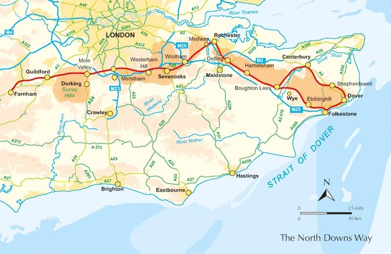
Productomschrijving: Een wandelgids over de North Downs Way nationale Trail, een parcours van de 130 mijl (208km) tussen Farnham en Dover, met een optioneel bezoek aan de Canterbury. Naar aanleiding van de grotendeelse oude pelgrimsroute, door aangenaam platteland, dit is een van de éénvoudigere nationale routes waar de wandeling over 11 etappes in wordt beschreven. Met 1:25K OS kaart boekje.
Product description: Guidebook to walking the North Downs Way National Trail, a 130 mile (208km) trail between Farnham and Dover, with an optional visit to Canterbury. Following the ancient Pilgrim's Way for much of the way, through pleasant countryside, this is one of the easier National Trails and the walk is described over 11 stages. With 1:25K OS map booklet.
Seasons:
The North Downs Way can be walked at any time of the year, but is seen at its best between April and October.
Centres:
Beginning in Farnham, the North Downs Way passes close-to or through Guildford, Otford, Wrotham, Detling, Charing, Wye, Chilham, Canterbury, Patrixbourne and ends in Dover.
Difficulty:
Despite some reasonably short steep ascents and descents, the North Downs Way is one of the more gentle of National Trails and is suitable for first-time long distance walkers.
Must See:
Passing through the Surrey and Kent Downs Areas of Outstanding Natural Beauty, the North Downs Way crosses Box Hill, visits Neolithic sites like the Coldrum Stones and Kits Coty House; passes below the remains of Thurnham Castle, visits Canterbury Cathedral, Dover Castle, and across Shakespeare Cliff, one of the White Cliffs of Dover.

Locatie op kaart
Overzichtskaarten

Area's of Outstanding Natural Beauty - AONB's UK
Area's of Outstanding Natural Beauty - AONB's UK

Producten op de overzichtskaart
Klik op een product om naar de detailpagina te gaan.
- Wandelgids - Guide to the Cotswolds AONB - AA
- Wandelkaart 24 - Chilterns AONB - AA
- Wandelgids - Cotswold classic walks guidebook - Goldeneye
- Wandelgids - Cotswold Classic Walks - Goldeneye
- Wandelgids - The Cotswold Way 30 classic routes - Cicerone
- Wandelgids - North Downs Way Nat. trail - Cicerone
- Wandelgids - Chilterns walking guide - Cicerone
- Wandelgids - Suffolk coast & Heaths walks - Cicerone
- Wandelgids - North Downs Way - Map Booklet - Cicerone
- Wandelgids - North Pennines AONB walking guide - Cicerone
- Wandelgids - Forest of Bowland & Pendle - Cicerone
- Wandelgids - Hampshire's Test Way walking guide - Cicerone
- Wandelgids & Fietsgids - The Cotswold AONB - Cicerone
- Wandelgids - North Wessex Downs - Cicerone Press
- Wandelgids - Walking on the North Wessex Downs - Cicerone
- Wandelgids - Silverdale & Arnside AONB - Cicerone
- Wandelkaart OL2 - Yorkshire Dales- Southern & Western Areas - OSI
- Wandelkaart OL19 - Howgill Fells and Upper Eden Valley - OSI
- Wandelkaart OL21 - South Pennines - Yorkshire - OSI
- Wandelkaart OL31 - North Pennines- Teesdale & Weardale - OSI
- Wandelkaart OL40 - The Broads - OSI
- Wandelkaart OL41 - Forest of Bowland & Ribblesdale - OSI
- Wandelkaart OL45 - The Cotswolds AONB- Gloucestershire - OSI
- Wandelkaart 108 - Lower Tamer Valley & Plymouth- Cornwall- OSI
- Wandelkaart 115 - Exmouth & Sidmouth- Devon - OSI
- Wandelkaart 137 - Ashford- Kent downs AONB- England - OSI
- Wandelkaart 140 - Quantock Hills AONB- Somerset - OSI
- Wandelkaart 140 - Quantock Hills AONB & Bridgwater- Devon - OSI
- Wandelkaart 147 - Sevenoaks & Tonbridge- Kent - OSI
- Wandelkaart 164 - Gower AONB & Gwyr- South Wales - OSI
- Wandelkaart 164 - Gower AONB & Gwyr- Wales - OSI
- Wandelkaart 171 - Chiltern Hills West & Henley-on-Thames OSI
- Wandelkaart 171 - Chiltern Hills West AONB- Wycombe - OSI
- Wandelkaart 172 - Chiltern Hills East AONB- Wycombe - OSI
- Wandelkaart 181 - Chiltern Hills AONB North- England - OSI
- Wandelkaart 181 - Chiltern Hills North AONB- Wycombe - OSI
- Wandelkaart 190 - Malvern Hills & Bredon Hill - OSI
- Wandelkaart 190 - Malvern Hills AONB & Bredon Hill - OSI
- Wandelkaart 203 - Ludlow- Shropshire Hills AONB - OSI
- Wandelkaart 217 - Long Mynd & Wenlock Edge- Schropshire- OSI
- Wandelkaart 254 - Lleyn Peninsular East- North Wales - OSI
- Wandelkaart 261 - Boston- Lincolnshire AONB - OSI
- Wandelkaart 262 - Anglesey West- Wales AONB - OSI
- Wandelkaart 263 - Anglesey East AONB- Wales - OSI
- Wandelkaart 273 - Lincolnshire Wolds South AONB - OSI
- Wandelkaart 282 - Lincolnshire Wolds North AONB - OSI
- Wandelkaart 298 - Nidderdale AONB- Yorkshire - OSI
- Wandelkaart 298 - Nidderdale AONB North Yorkshire - OSI
- Wandelkaart 300 - Howardian Hills AONB - OSI
- Wandelkaart 300 - Howardian Hills AONB & Malton - OSI
- Wandelkaart - Mourne Mountains N. Ireland - Harvey maps
- Wandelkaart - Fietskaart Forest of Bowland - Harvey maps
- Wandelkaart XT40 - Anglesey Coastal Path N. Wales - Harvey Maps
- Wandelkaart XT40 - Pennine Way Noord - Harvey Maps
- Wandelkaart XT40 - Pennine Way Zuid - Harvey Maps
- Wandelgids Cotswold - Way Two-way trekking guide - Knife Edge
- Reisgids Cotswolds England - Rough Guides
Artikelen uit dezelfde regio
Fietsgids Traffic-Free Cycle Trails S.E. England - Vertebrate • 9781839811647
Traffic-Free Cycle Trails South East England - Vertebrate Productomschrijving: The essential guide to over 100 traffic-free cycling trails in South East England. Traffic-Free Cycle Trails South East England by Nick Cotton and Kathy Rogers features over 100 great cycling routes across the South East, London and into Eastern England. A companion guide to Nick Cotton’s bestselling Traffi…

Wandelkaart North Downs Way - Harvey maps • 9781851375295
Wandelkaart North Downs Way - Harvey maps Productomschrijving: Meer dan een kaart, een essentieel nieuw stuk met indeling, deze HARVEY routekaart toont het geheel van de North Downs Way op één vel. Het is een duidelijk gedetailleerde route. Het bevat ook informatie over accommodatie en diensten, handige telefoonnummers om te helpen met de planning en de volledige tour. Gedrukt op 100% wate…

Wandelgids The Pilgrim's Way - Cicerone • 9781852847777
Wandelgids - The Pilgrim's Way - Cicerone Productomschrijving: Een samenstelling van alle route gegevens van deze uitermate gekende St-jacobs/bedevaart wandelroute in hartje Engeland. Product description: This guidebook details the Pilgrims' Way, an historic pilgrimage route to Canterbury Cathedral in Kent, home of the shrine of the martyred archbishop, St Thomas Becket. The route is…

Wandelgids Cheddar & the Mendips - 15 short walks - Cicerone • 9781786312549
Wandelgids 15 short walks Cheddar & the Mendips - Cicerone Productomschrijving: Would you like to explore the best of Cheddar and the Mendips? This guidebook covers 15 of the best short walks in the area (between 3 and 10km, all under three hours), including Crook Peak and King's Wood, Beacon Batch and Velvet Bottom, Ebbor Gorge and Ebbor Wood, Cheddar Gorge North and Piney Sleights and th…

Landkaart Wegenkaart 504 S.E. Engeland & East Anglia - Michelin • 9782067183322
Regionale Wegenkaart South East Engeland & East Anglia Productomschrijving: De volledig bijgewerkte MICHELIN-kaart van Engeland Zuid-Oost, Midlands, Oost-England geeft u alle WEG- EN TOERISME-informatie die u nodig hebt om uw reizen in deze regio te optimaliseren: een INDEX VAN LOCATIES, een TABEL VAN AFSTANDEN en REISTIJDEN. Dankzij de schaal van 1:400.000 (1 cm = 4 km) kun je zowel de h…