

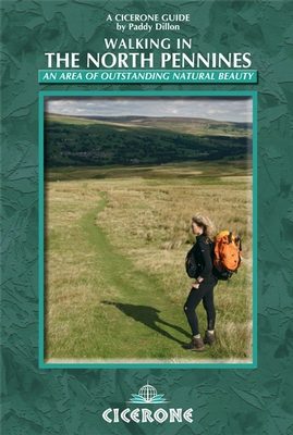
Wandelgids - North Pennines AONB walking guide - Cicerone
50 dag wandelingen over de Noordelijke Pennines AONB

Korte omschrijving
Wandelgidsen North East England van CICERONE Press. Ideaal voor tochten in England.
Wandelgids - North Pennines AONB walking guide - Cicerone Omschrijving: Deze handige gids beschrijft 50 dag wandelingen over de Noordelijke Pennines AONB met routes geschikt voor alle leefti...

Specificaties
- Uitgever: CICERONE Press
- ISBN-13: 9781852849054
- HOOFDCATEGORIEËN: Wandelgids
- Activiteiten: Wandelen, Hiking & Trekking
- Regio: North East England
- Land: England
- AONB - Area of Outstanding Beauty/National Landscape: Northern Pennines AONB
- Editie: 3
- Taal: Engels
Volledige omschrijving
Wandelgids - North Pennines AONB walking guide - Cicerone
Omschrijving: Deze handige gids beschrijft 50 dag wandelingen over de Noordelijke Pennines AONB met routes geschikt voor alle leeftijden. Zij omvatten een scala aan verschillend terrein van zachte rivier ballades tot ruige Heide wandelingen. De selectie van routes zijn voornamelijk circulaire met een paar lineaire routes, en variëren van 8km tot 23km. Perfect voor degenen die de wilde Pennines willen verkennen.
Product description: This handy guidebook describes 50 day walks across the North Pennines AONB with routes suitable for all abilities. They cover a variety of terrain from gentle riverside strolls to rugged moorland walks. The selection of routes are mainly circular with some linear trails and range from 8km to 23km. Perfect for those seeking to explore the wild Pennines.
Seasons:
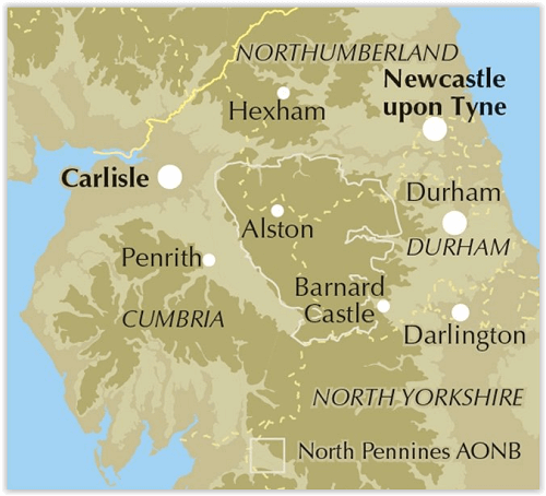
All year round - region famous for its bleak and blustery weather!Centres CentresHexham, Consett, Barnard Castle, Kirkby Stephen, Appleby and Brampton.
Difficulty:
A variety of terrain from riverside strolls and old railway trackbeds to rugged moorland; walks up to 14 miles (23km) in length but nothing difficult; ability to navigate essential because of changing weather conditions.
Must See:
England's last wilderness; Area of Outstanding Natural Beauty; Vale of Eden; fascinating geology eg the Whin Sill (first Geopark in England in 2003); rich industrial heritage (eg Killhope lead-mining museum).
Locatie op kaart
Overzichtskaarten

Area's of Outstanding Natural Beauty - AONB's UK
Area's of Outstanding Natural Beauty - AONB's UK

Producten op de overzichtskaart
Klik op een product om naar de detailpagina te gaan.
- Wandelgids - Guide to the Cotswolds AONB - AA
- Wandelkaart 24 - Chilterns AONB - AA
- Wandelgids - Cotswold classic walks guidebook - Goldeneye
- Wandelgids - Cotswold Classic Walks - Goldeneye
- Wandelgids - The Cotswold Way 30 classic routes - Cicerone
- Wandelgids - North Downs Way Nat. trail - Cicerone
- Wandelgids - Chilterns walking guide - Cicerone
- Wandelgids - Suffolk coast & Heaths walks - Cicerone
- Wandelgids - North Downs Way - Map Booklet - Cicerone
- Wandelgids - North Pennines AONB walking guide - Cicerone
- Wandelgids - Forest of Bowland & Pendle - Cicerone
- Wandelgids - Hampshire's Test Way walking guide - Cicerone
- Wandelgids & Fietsgids - The Cotswold AONB - Cicerone
- Wandelgids - North Wessex Downs - Cicerone Press
- Wandelgids - Walking on the North Wessex Downs - Cicerone
- Wandelgids - Silverdale & Arnside AONB - Cicerone
- Wandelkaart OL2 - Yorkshire Dales- Southern & Western Areas - OSI
- Wandelkaart OL19 - Howgill Fells and Upper Eden Valley - OSI
- Wandelkaart OL21 - South Pennines - Yorkshire - OSI
- Wandelkaart OL31 - North Pennines- Teesdale & Weardale - OSI
- Wandelkaart OL40 - The Broads - OSI
- Wandelkaart OL41 - Forest of Bowland & Ribblesdale - OSI
- Wandelkaart OL45 - The Cotswolds AONB- Gloucestershire - OSI
- Wandelkaart 108 - Lower Tamer Valley & Plymouth- Cornwall- OSI
- Wandelkaart 115 - Exmouth & Sidmouth- Devon - OSI
- Wandelkaart 137 - Ashford- Kent downs AONB- England - OSI
- Wandelkaart 140 - Quantock Hills AONB- Somerset - OSI
- Wandelkaart 140 - Quantock Hills AONB & Bridgwater- Devon - OSI
- Wandelkaart 147 - Sevenoaks & Tonbridge- Kent - OSI
- Wandelkaart 164 - Gower AONB & Gwyr- South Wales - OSI
- Wandelkaart 164 - Gower AONB & Gwyr- Wales - OSI
- Wandelkaart 171 - Chiltern Hills West & Henley-on-Thames OSI
- Wandelkaart 171 - Chiltern Hills West AONB- Wycombe - OSI
- Wandelkaart 172 - Chiltern Hills East AONB- Wycombe - OSI
- Wandelkaart 181 - Chiltern Hills AONB North- England - OSI
- Wandelkaart 181 - Chiltern Hills North AONB- Wycombe - OSI
- Wandelkaart 190 - Malvern Hills & Bredon Hill - OSI
- Wandelkaart 190 - Malvern Hills AONB & Bredon Hill - OSI
- Wandelkaart 203 - Ludlow- Shropshire Hills AONB - OSI
- Wandelkaart 217 - Long Mynd & Wenlock Edge- Schropshire- OSI
- Wandelkaart 254 - Lleyn Peninsular East- North Wales - OSI
- Wandelkaart 261 - Boston- Lincolnshire AONB - OSI
- Wandelkaart 262 - Anglesey West- Wales AONB - OSI
- Wandelkaart 263 - Anglesey East AONB- Wales - OSI
- Wandelkaart 273 - Lincolnshire Wolds South AONB - OSI
- Wandelkaart 282 - Lincolnshire Wolds North AONB - OSI
- Wandelkaart 298 - Nidderdale AONB- Yorkshire - OSI
- Wandelkaart 298 - Nidderdale AONB North Yorkshire - OSI
- Wandelkaart 300 - Howardian Hills AONB - OSI
- Wandelkaart 300 - Howardian Hills AONB & Malton - OSI
- Wandelkaart - Mourne Mountains N. Ireland - Harvey maps
- Wandelkaart - Fietskaart Forest of Bowland - Harvey maps
- Wandelkaart XT40 - Anglesey Coastal Path N. Wales - Harvey Maps
- Wandelkaart XT40 - Pennine Way Noord - Harvey Maps
- Wandelkaart XT40 - Pennine Way Zuid - Harvey Maps
- Wandelgids Cotswold - Way Two-way trekking guide - Knife Edge
- Reisgids Cotswolds England - Rough Guides
Artikelen uit dezelfde regio
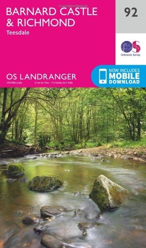
Wandelkaart 92 Barnard Castle Teesdale - England - OSI • 9780319263396
Wandelkaart Barnard Castle - Teesdale Durham england Productomschrijving: Barnard Castle is een marktplaats in het Engelse Durham in het Penninisch Gebergte. De plaats hoorde bij een groot kasteel waarvan de ruïne aan de Tees nog opvallend aanwezig is. Deze kaart, als onderdeel van de Landranger active waterproff series, is een topografische kaart voor wandelaars, de kwaliteit is onevenaa…

Wandelkaart 308 Durnham & Sunderland- Durham - OSI • 9780319471807
Wandelkaart Durnham & Sunderland - Nort East England Productbeschrijving: Kaart nummer 308 omvat Chester-Le-Street, Durham, Sunderland en Peterlee. Hoogtepunten zijn onder andere de kathedraal van Durham, rivier de Wear, Houghton-Le Spring en Seaham. Bevat ook Great Lumley, Brandon, Shiney Row and Hetton-Le-Hole. De OS Explorer kaart voor Durham & Sunderland is beschikbaar in zowel de stan…

Wandelgids Durham County walking guide - Cicerone • 9781786311375
Wandelgids Durham County walking guide - Cicerone Productomschrijving: Gids met gedetailleerde beschrijvingen van 40 dagwandelingen door het graafschap Durham. De wandelingen variëren van 5 tot 24 km en laten de geschiedenis en natuurlijke wonderen van de regio zien. Het terrein beslaat veldwegen en open heidevelden, van de Noordzee tot de hoge Pennines. Engelse omschrijving: Guidebook…

Wandelkaart 88 Newcastle upon Tyne- N.E. England - OSI • 9780319474112
Wandelkaart Newcastle upon Tyne - North East England Productbeschrijving: Kaart nummer 88 in de OS Landranger kaarten reeks is de ideale kaart voor planning van excursies en vakanties in het noordoosten van Engeland. Verken het oostelijke gedeelte van de Hadrian's Wall pad, samen met de historische steden van Newcastle upon Tyne en Durham. Andere plaatsen op de kaart opgenomen zijn Gatesh…
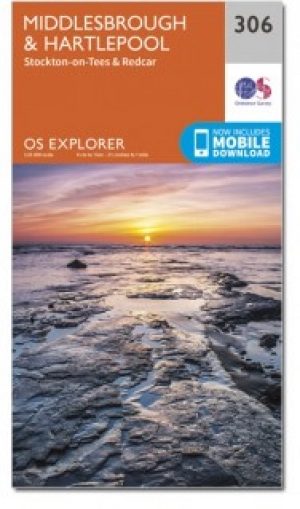
Wandelkaart 306 Middlesbrough & Hartlepool - OSI • 9780319471784
WandelkaartMiddlesbrough & Hartlepool - North East England Omvat ook: Stockton-on-Tees & Redcar. Productbeschrijving: OS Explorer kaart 306 omvat het gebied rond Middlesbrough in het noordoosten van Engeland, deze kaart behandelt Hartlepool en Redcar, Stockton-on-Tees en de rivier de Tees. Hoogtepunten van het gebied zijn de Tees Forest, Teesdale Way, Tees Link en delen van de Clevelan…