

Wandelkaart 181 - Chiltern Hills AONB North- England - OSI
Omvat The Chilterns AONB- Aylesbury Ring & de Ridgeway


Korte omschrijving
Wandelkaarten Oxfordshire west England, Buckinghamshire, England, Bedfordshire, England en Herefordshire, England van Ordnance Survey. Ideaal voor tochten in England.
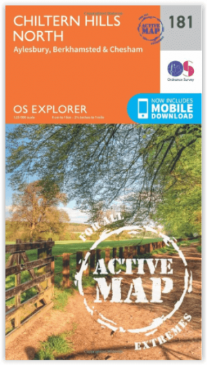
Wandelkaart Chiltern Hills AONB North - Oxfordshire Omvat ook: Aylesbury, Berkhamsted & Chesham. Productbeschrijving: Kaart nummer 181 in de OS Explorer reeks omvat Aylesbury, Wendover, ...

Specificaties
- Uitgever: Ordnance Survey
- ISBN-13: 9780319470534
- HOOFDCATEGORIEËN: Wandelkaart
- Activiteiten: Wandelen, Hiking & Trekking
- Regio: Bedfordshire, England, Buckinghamshire, England, Herefordshire, England, Oxfordshire west England
- Land: England
- Waterafstotende kaart: Ordnance Survey ACTIVE Explorer Weatherproof Maps
- TOPO's & Stafkaarten: Topografisch wandelen
- AONB - Area of Outstanding Beauty/National Landscape: The Chilterns AONB
- Schaal: 1:25000
- Taal: Engels
- Reeks/Serie: Explorer ACTIVE Series OSI
Volledige omschrijving
Wandelkaart Chiltern Hills AONB North - Oxfordshire
Omvat ook: Aylesbury, Berkhamsted & Chesham.
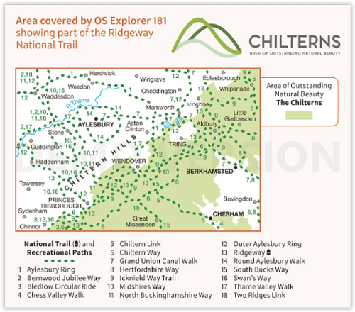
Productbeschrijving: Kaart nummer 181 in de OS Explorer reeks omvat Aylesbury, Wendover, Berkhamstead, Chesham, Princes Risborough en Tring. Hoogtepunten van het gebied zijn The Chiltern Hills, rivier Thame, The Chilterns AONB, Aylesbury Ring, de Ridgeway en de Chiltern way. De OS Explorer kaart voor Chiltern Hills Noord is beschikbaar in zowel de standaard papieren versie als de weerbestendige 'Actief' versie.
Productdiscription: Map sheet number 181 in the OS Explorer series covers Aylesbury, Wendover, Berkhamstead, Chesham, Princes Risborough and Tring. Highlights of the area include: The Chiltern Hills, River Thame, The Chilterns AONB, Chiltern Hills, Aylesbury Ring, the Ridgeway and the Chiltern Way. The OS Explorer map for Chiltern Hills North is available in both the standard paper version and weatherproof 'Active' version.
Locatie op kaart
Gekoppelde artikelen

Wandelkaart 181 Chiltern Hills North AONB- Wycombe - OSI • 9780319243749
standaard versieWandelkaart Chiltern Hills North AONB - Wycombe - OSI Productbeschrijving: Aylesbury- Berkhamsted & Chesham. 181 / Chiltern Hills North, Wycombe, England - Kaart nummer 181 in de OS Explorer reeks omvat Aylesbury, Wendover, Berkhamstead, Chesham, Princes Risborough en Tring. Hoogtepunten van het gebied: The Chiltern Hills, rivier Thames, The Chilterns AONB, Chiltern Hills, Aylesbury R…
Wandelkaart 181 - Chiltern Hills AONB North- England - OSI • 9780319470534
weatherproof versieWandelkaart Chiltern Hills AONB North - Oxfordshire Omvat ook: Aylesbury, Berkhamsted & Chesham. Productbeschrijving: Kaart nummer 181 in de OS Explorer reeks omvat Aylesbury, Wendover, Berkhamstead, Chesham, Princes Risborough en Tring. Hoogtepunten van het gebied zijn The Chiltern Hills, rivier Thame, The Chilterns AONB, Aylesbury Ring, de Ridgeway en de Chiltern way. De OS Explorer …
Overzichtskaarten

Area's of Outstanding Natural Beauty - AONB's UK
Area's of Outstanding Natural Beauty - AONB's UK

Producten op de overzichtskaart
Klik op een product om naar de detailpagina te gaan.
- Wandelgids - Guide to the Cotswolds AONB - AA
- Wandelkaart 24 - Chilterns AONB - AA
- Wandelgids - Cotswold classic walks guidebook - Goldeneye
- Wandelgids - Cotswold Classic Walks - Goldeneye
- Wandelgids - The Cotswold Way 30 classic routes - Cicerone
- Wandelgids - North Downs Way Nat. trail - Cicerone
- Wandelgids - Chilterns walking guide - Cicerone
- Wandelgids - Suffolk coast & Heaths walks - Cicerone
- Wandelgids - North Downs Way - Map Booklet - Cicerone
- Wandelgids - North Pennines AONB walking guide - Cicerone
- Wandelgids - Forest of Bowland & Pendle - Cicerone
- Wandelgids - Hampshire's Test Way walking guide - Cicerone
- Wandelgids & Fietsgids - The Cotswold AONB - Cicerone
- Wandelgids - North Wessex Downs - Cicerone Press
- Wandelgids - Walking on the North Wessex Downs - Cicerone
- Wandelgids - Silverdale & Arnside AONB - Cicerone
- Wandelkaart OL2 - Yorkshire Dales- Southern & Western Areas - OSI
- Wandelkaart OL19 - Howgill Fells and Upper Eden Valley - OSI
- Wandelkaart OL21 - South Pennines - Yorkshire - OSI
- Wandelkaart OL31 - North Pennines- Teesdale & Weardale - OSI
- Wandelkaart OL40 - The Broads - OSI
- Wandelkaart OL41 - Forest of Bowland & Ribblesdale - OSI
- Wandelkaart OL45 - The Cotswolds AONB- Gloucestershire - OSI
- Wandelkaart 108 - Lower Tamer Valley & Plymouth- Cornwall- OSI
- Wandelkaart 115 - Exmouth & Sidmouth- Devon - OSI
- Wandelkaart 137 - Ashford- Kent downs AONB- England - OSI
- Wandelkaart 140 - Quantock Hills AONB- Somerset - OSI
- Wandelkaart 140 - Quantock Hills AONB & Bridgwater- Devon - OSI
- Wandelkaart 147 - Sevenoaks & Tonbridge- Kent - OSI
- Wandelkaart 164 - Gower AONB & Gwyr- South Wales - OSI
- Wandelkaart 164 - Gower AONB & Gwyr- Wales - OSI
- Wandelkaart 171 - Chiltern Hills West & Henley-on-Thames OSI
- Wandelkaart 171 - Chiltern Hills West AONB- Wycombe - OSI
- Wandelkaart 172 - Chiltern Hills East AONB- Wycombe - OSI
- Wandelkaart 181 - Chiltern Hills AONB North- England - OSI
- Wandelkaart 181 - Chiltern Hills North AONB- Wycombe - OSI
- Wandelkaart 190 - Malvern Hills & Bredon Hill - OSI
- Wandelkaart 190 - Malvern Hills AONB & Bredon Hill - OSI
- Wandelkaart 203 - Ludlow- Shropshire Hills AONB - OSI
- Wandelkaart 217 - Long Mynd & Wenlock Edge- Schropshire- OSI
- Wandelkaart 254 - Lleyn Peninsular East- North Wales - OSI
- Wandelkaart 261 - Boston- Lincolnshire AONB - OSI
- Wandelkaart 262 - Anglesey West- Wales AONB - OSI
- Wandelkaart 263 - Anglesey East AONB- Wales - OSI
- Wandelkaart 273 - Lincolnshire Wolds South AONB - OSI
- Wandelkaart 282 - Lincolnshire Wolds North AONB - OSI
- Wandelkaart 298 - Nidderdale AONB- Yorkshire - OSI
- Wandelkaart 298 - Nidderdale AONB North Yorkshire - OSI
- Wandelkaart 300 - Howardian Hills AONB - OSI
- Wandelkaart 300 - Howardian Hills AONB & Malton - OSI
- Wandelkaart - Mourne Mountains N. Ireland - Harvey maps
- Wandelkaart - Fietskaart Forest of Bowland - Harvey maps
- Wandelkaart XT40 - Anglesey Coastal Path N. Wales - Harvey Maps
- Wandelkaart XT40 - Pennine Way Noord - Harvey Maps
- Wandelkaart XT40 - Pennine Way Zuid - Harvey Maps
- Wandelgids Cotswold - Way Two-way trekking guide - Knife Edge
- Reisgids Cotswolds England - Rough Guides
Artikelen uit dezelfde regio

Wandelgids Oxfordshire 50 walks guide - AA Publishing • 9780749583743
Wandelgids Oxfordshire - 50 walks guide - AA Publishing Productomschrijving: Deze gids bevat 50 uitgestippelde wandelingen voor alle niveaus, van rustige wandelingen tot langere tochten. Het boek bevat 50 wandelingen van 2-10 mijl in Oxfordshire en bevat alle praktische details die u nodig hebt, vergezeld van boeiende achtergrondinformatie over de geschiedenis en de flora en fauna van het …

Wandelkaart 166 Luton- Hertford & Hitchin- Bedfordshire - OSI • 9780319474891
Wandelkaart 166 - Luton- Hertford & Hitchin- Bedfordshire Productbeschrijving: Het platteland van Hertfordshire gedekt door OS Landranger kaart 166 trekt wandel- en fietsroute enthusiastellingen aan, en voor een goede reden. Er zijn vele wandel- of fietstroutes zoals de Cole Green way alngs de oude spoorweg van Hertford aan de unieke Welwyn Garden City. De OS Landranger kaarten reeks h…

Wandelkaart 193 Luton & Stevenage- Bedfordshire - OSI • 9780319243862
Wandelkaart Luton & Stevenage - Bedfordshire England Omvat ook: Hitchin & Ampthill Productomschrijving: Kaart nummer 193 in de OS Explorer kaarten reeks omvat The Chilterns AONB. De Chiltern way, Icknield way Trail en John Bunyan Trail zijn maar enkele van de wandelingen in dit gebied die gaan langs de steden van Luton, Stevenage, Hitchin en Ampthill. De OS Explorer kaart voor Luton & …

Wandelkaartv OL14 Wye Valley, Forest of Dean & Dyfryn Gwy - OS • 9780319263839
Wandelkaartv Wye Valley, Forest of Dean & Dyfryn Gwy - OS Productomschrijving: Parts of Offa's Dyke Path, on the border of England & Wales. Omvat: Wye Valley, Forest of Dean & Dyfryn Gwy, Wye Valley AONB, Daffodil Way, Gloucestershire Way, Herefordshire Way, Jubilee Way, Offa's Dyke Path, Severn Way, Thames & Severn Way, Three Coastal Walk, Wales Coast Path, Wye Valley Walk & Wysis Way…

Wandelkaart 202 Leominster & Bromyard Hererfordshire - OSI • 9780319243954
Wandelkaart Leominster & Bromyard - Hererfordshire England Productbeschrijving: Kaart nummer 202 dekt Leominster, Bromyard en Hereford. Hoogtepunten zijn de Herefordshire trail, Bromyard Downs, Three Choirs Way en de Wye Valley Walk. Omvat ook Burghill en Bodenham. De OS Explorer kaart voor Leominster & Bromyard is beschikbaar in zowel de standaard papieren versie als de weerbestendige 'Ac…