

Wandelgids Cotswold - Way Two-way trekking guide - Knife Edge
The Cotswold way - 164 km

Korte omschrijving
Wandelgidsen Somerset South West England, Warwickshire, West Midlands, Wiltshire, West England, Worcestershire, West England, Gloucestershire, Egland en Oxfordshire west England van Knife Edge Outdoor Limited. Ideaal voor tochten in England.
Cotswold - Way Two-way trekking guide - Knife Edge Productomschrijving: De Cotswold Way legt 102 mijl af door het sublieme landschap van de Cotswolds, een streek die het toonbeeld is van his...

Specificaties
- Uitgever: Knife Edge Outdoor Limited
- ISBN-13: 9781912933136
- HOOFDCATEGORIEËN: Wandelgids
- Activiteiten: Wandelen, Hiking & Trekking
- Regio: Gloucestershire, Egland, Oxfordshire west England, Somerset South West England, Warwickshire, West Midlands, Wiltshire, West England, Worcestershire, West England
- Land: England
- Lange afstand wandelroutes: Cotswold Way, England (164km)
- AONB - Area of Outstanding Beauty/National Landscape: Cotswolds AONB
- Editie: 1
- Taal: Engels
- National Trails UK, England & Wales: Cotswolds Way, England
Volledige omschrijving
Cotswold - Way Two-way trekking guide - Knife Edge
Productomschrijving: De Cotswold Way legt 102 mijl af door het sublieme landschap van de Cotswolds, een streek die het toonbeeld is van historisch Engeland. Onderweg gaat u over de top van de Cotswold Escarpment door een prachtig glooiend landschap en historische chocolade-doosdorpjes, gebouwd van prachtige honingkleurige stenen, die eeuwenlang onveranderd zijn gebleven. De Cotswold behoren tot de befaamde AONB regio's, de Area of Outstanding Natural Beaty.
De trekker doorkruist dit prachtige terrein op een nauwkeurig aangegeven reeks paden en wegen, ver weg van de grote stedelijke centra van de regio. Af en toe passeert u een klein dorp of gehucht (met niet veel meer dan een plaatselijke pub en een paar overnachtingsmogelijkheden), maar verder is de ervaring er een van rust. Dit is Engeland op zijn best en het zal een avontuur zijn dat u nooit zult vergeten.
Engelse omschrijving: The Cotswold Way travels 102 miles through the sublime scenery of the Cotswolds, a region which is the epitome of historic England. Along the way, you will travel the crest of the Cotswold Escarpment through exquisite rolling countryside and historic chocolate-box villages, built from lovely honey-coloured stone, which have remained unchanged for centuries.
The trekker negotiates this wonderful terrain on a meticulously waymarked series of paths and tracks, far removed from the region’s large urban centres. Occasionally, you will pass through a small village or hamlet (with little more than a local pub and a few places to stay) but otherwise, the experience is one of tranquillity. This is England at its best and it will be an adventure that you will never forget.
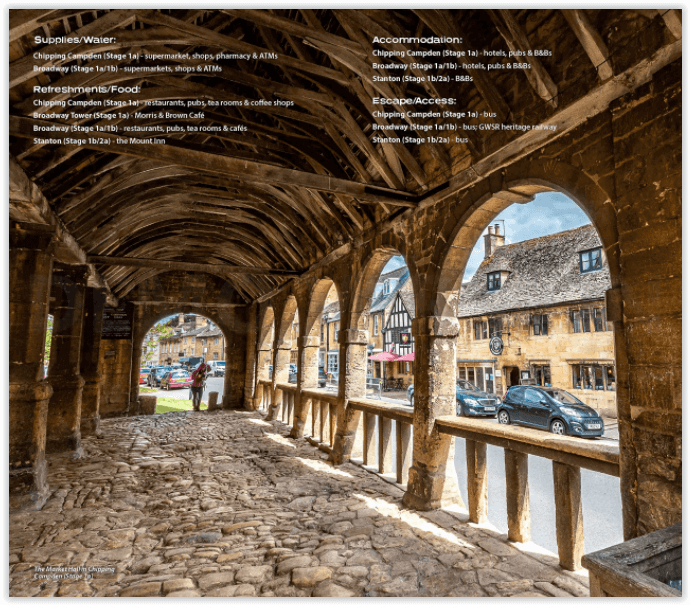
The definitive two-way guide to the Cotswold Way: both southbound and northbound routes are described in full. Real Maps: Full Ordnance Survey mapping inside (1:25,000). All accommodation is numbered and marked on the maps. 18 different itineraries: schedules of 4, 5, 6, 7, 8, 9, 10, 11 and 12 days for hikers and runners. Includes both southbound and northbound itineraries. Difficult calculations of time, distance and altitude gain/loss are done for you.
Also includes:
• Detailed information on equipment and travelling light
• Everything the trekker needs to know: route, costs, difficulty, weather, travel, and more
• Full accommodation listings: the best inns, B&Bs and hotels
• Detailed section on camping
• What to see in the City of Bath
• Essential info for both self-guided and guided trekkers
• Information on history, plants and wildlife
• Numbered waypoints linking the Real Maps to our clear descriptions
Locatie op kaart
Overzichtskaarten

Area's of Outstanding Natural Beauty - AONB's UK
Area's of Outstanding Natural Beauty - AONB's UK

Producten op de overzichtskaart
Klik op een product om naar de detailpagina te gaan.
- Wandelgids - Guide to the Cotswolds AONB - AA
- Wandelkaart 24 - Chilterns AONB - AA
- Wandelgids - Cotswold classic walks guidebook - Goldeneye
- Wandelgids - Cotswold Classic Walks - Goldeneye
- Wandelgids - The Cotswold Way 30 classic routes - Cicerone
- Wandelgids - North Downs Way Nat. trail - Cicerone
- Wandelgids - Chilterns walking guide - Cicerone
- Wandelgids - Suffolk coast & Heaths walks - Cicerone
- Wandelgids - North Downs Way - Map Booklet - Cicerone
- Wandelgids - North Pennines AONB walking guide - Cicerone
- Wandelgids - Forest of Bowland & Pendle - Cicerone
- Wandelgids - Hampshire's Test Way walking guide - Cicerone
- Wandelgids & Fietsgids - The Cotswold AONB - Cicerone
- Wandelgids - North Wessex Downs - Cicerone Press
- Wandelgids - Walking on the North Wessex Downs - Cicerone
- Wandelgids - Silverdale & Arnside AONB - Cicerone
- Wandelkaart OL2 - Yorkshire Dales- Southern & Western Areas - OSI
- Wandelkaart OL19 - Howgill Fells and Upper Eden Valley - OSI
- Wandelkaart OL21 - South Pennines - Yorkshire - OSI
- Wandelkaart OL31 - North Pennines- Teesdale & Weardale - OSI
- Wandelkaart OL40 - The Broads - OSI
- Wandelkaart OL41 - Forest of Bowland & Ribblesdale - OSI
- Wandelkaart OL45 - The Cotswolds AONB- Gloucestershire - OSI
- Wandelkaart 108 - Lower Tamer Valley & Plymouth- Cornwall- OSI
- Wandelkaart 115 - Exmouth & Sidmouth- Devon - OSI
- Wandelkaart 137 - Ashford- Kent downs AONB- England - OSI
- Wandelkaart 140 - Quantock Hills AONB- Somerset - OSI
- Wandelkaart 140 - Quantock Hills AONB & Bridgwater- Devon - OSI
- Wandelkaart 147 - Sevenoaks & Tonbridge- Kent - OSI
- Wandelkaart 164 - Gower AONB & Gwyr- South Wales - OSI
- Wandelkaart 164 - Gower AONB & Gwyr- Wales - OSI
- Wandelkaart 171 - Chiltern Hills West & Henley-on-Thames OSI
- Wandelkaart 171 - Chiltern Hills West AONB- Wycombe - OSI
- Wandelkaart 172 - Chiltern Hills East AONB- Wycombe - OSI
- Wandelkaart 181 - Chiltern Hills AONB North- England - OSI
- Wandelkaart 181 - Chiltern Hills North AONB- Wycombe - OSI
- Wandelkaart 190 - Malvern Hills & Bredon Hill - OSI
- Wandelkaart 190 - Malvern Hills AONB & Bredon Hill - OSI
- Wandelkaart 203 - Ludlow- Shropshire Hills AONB - OSI
- Wandelkaart 217 - Long Mynd & Wenlock Edge- Schropshire- OSI
- Wandelkaart 254 - Lleyn Peninsular East- North Wales - OSI
- Wandelkaart 261 - Boston- Lincolnshire AONB - OSI
- Wandelkaart 262 - Anglesey West- Wales AONB - OSI
- Wandelkaart 263 - Anglesey East AONB- Wales - OSI
- Wandelkaart 273 - Lincolnshire Wolds South AONB - OSI
- Wandelkaart 282 - Lincolnshire Wolds North AONB - OSI
- Wandelkaart 298 - Nidderdale AONB- Yorkshire - OSI
- Wandelkaart 298 - Nidderdale AONB North Yorkshire - OSI
- Wandelkaart 300 - Howardian Hills AONB - OSI
- Wandelkaart 300 - Howardian Hills AONB & Malton - OSI
- Wandelkaart - Mourne Mountains N. Ireland - Harvey maps
- Wandelkaart - Fietskaart Forest of Bowland - Harvey maps
- Wandelkaart XT40 - Anglesey Coastal Path N. Wales - Harvey Maps
- Wandelkaart XT40 - Pennine Way Noord - Harvey Maps
- Wandelkaart XT40 - Pennine Way Zuid - Harvey Maps
- Wandelgids Cotswold - Way Two-way trekking guide - Knife Edge
- Reisgids Cotswolds England - Rough Guides
Artikelen uit dezelfde regio

Wandelgids Cotswolds AONB 50 walks guide - AA Publishing • 9780749583224
Cotswolds AONB - 50 walks guide - AA Publishing Productomschrijving: Wandelen is een van de favoriete vrijetijdsbestedingen van Groot-Brittannië. AA 50 Walks in the Cotswolds bevat een verscheidenheid aan uitgestippelde wandelingen van 3 tot 12 km, geschikt voor alle niveaus. Het boek bevat alle praktische details die u nodig hebt, vergezeld van boeiende achtergrondinformatie over de gesch…

Fietsgids South East Mountain Biking - Vertebrate Publ. • 9781906148058
South East Mountain Biking - Vertebrate Productomschrijving: South East Mountain Biking Ridgeway & Chilterns (Hills AONB) is a compact guide to some of the best mountain bike riding in Southern England, west of London. This guide contains 24 routes from 18 to 38 kilometres long. Each is described with easy-to-follow directions and details of distance, grade of difficulty, refreshment stops…

Wandelkaart 143 Warminster & Trowbridge- Wiltshire - OSI • 9780319470152
Wandelkaart Warminster & Trowbridge - Wiltshire England Productbeschrijving: Kaart nummer 143 in de OS Explorer kaarten reeks heeft betrekking op het westen van Wiltshire, alsook Cranbone Chase & West Wiltshire Downs. Hoogtepunten van het gebied zijn onder andere: Mid Wilts Way, Wessex Ridgeway, Monarch Way en Imber Range Perimeter Path. De OS Explorer kaart voor Warminster & Trowbridge is…

Wandelkaart 206 Edge Hill & Fenny Compton - OSI • 9780319243992
Wandelkaart Edge Hill & Fanny Compton - Warwickshire Productbeschrijving: Badby, Kineton & Middle Tysoe. 206 / Edge Hill & Fenny Compton, Warwickshire, England - Kaart nummer 206 in de OS Explorer kaart reeks is ideaal voor het ontdekken van het noordelijke deel van de Cotswolds. Dit gebied van uitzonderlijke natuurlijke schoonheid AONB kan worden bezocht dmv het aflopen van de Centen…
Wandelkaart 181 - Chiltern Hills AONB North- England - OSI • 9780319470534
Wandelkaart Chiltern Hills AONB North - Oxfordshire Omvat ook: Aylesbury, Berkhamsted & Chesham. Productbeschrijving: Kaart nummer 181 in de OS Explorer reeks omvat Aylesbury, Wendover, Berkhamstead, Chesham, Princes Risborough en Tring. Hoogtepunten van het gebied zijn The Chiltern Hills, rivier Thame, The Chilterns AONB, Aylesbury Ring, de Ridgeway en de Chiltern way. De OS Explorer …