

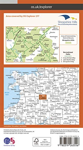
Wandelkaart 217 - Long Mynd & Wenlock Edge- Schropshire- OSI
Long Mynd is a heath and moorland in the Shropshire Hills

Korte omschrijving
Wandelkaarten Shropshire West Midlands van Ordnance Survey. Ideaal voor tochten in England.
Wandelkaart Long Mynd & Wenlock Edge - Schropshire England Engelse omschrijving: The Long Mynd is a heath and moorland plateau that forms part of the Shropshire Hills in Shropshire AONB, Eng...

Specificaties
- Uitgever: Ordnance Survey
- ISBN-13: 9780319475492
- HOOFDCATEGORIEËN: Wandelkaart
- Activiteiten: Wandelen, Hiking & Trekking
- Regio: Shropshire West Midlands
- Land: England
- Waterafstotende kaart: Ordnance Survey ACTIVE Explorer Weatherproof Maps
- TOPO's & Stafkaarten: Topografisch wandelen
- AONB - Area of Outstanding Beauty/National Landscape: Shropshire Hills AONB
- Schaal: 1:25000
- Taal: Engels
- Reeks/Serie: Explorer ACTIVE Series OSI
Volledige omschrijving
Wandelkaart Long Mynd & Wenlock Edge - Schropshire England
Engelse omschrijving: The Long Mynd is a heath and moorland plateau that forms part of the Shropshire Hills in Shropshire AONB, England. The high ground, which is designated as an Area of Outstanding Natural Beauty, lies between the Stiperstones range to the west and the Stretton Hills and Wenlock Edge to the east. Much of it is owned and managed by the National Trust.
Omvat eveneens: Church Stretton, Craven Arms
Explorer Active waterproof versie : ISBN - 9780319475492
Explorer series NON waterproof: ISBN - 9780319263556

Locatie op kaart
Gekoppelde artikelen

Wandelkaart 217 Long Mynd & Wenlock Edge - OSI • 9780319263556
standaard versieWandelkaart Long Mynd & Wenlock Edge - Egland Engels productomschrijving: The Long Mynd is a heath and moorland plateau that forms part of the Shropshire Hills AONB in Shropshire, England. The high ground, which is designated as an Area of Outstanding Natural Beauty, lies between the Stiperstones range to the west and the Stretton Hills and Wenlock Edge to the east. Much of it is owned and…
Overzichtskaarten

Area's of Outstanding Natural Beauty - AONB's UK
Area's of Outstanding Natural Beauty - AONB's UK

Producten op de overzichtskaart
Klik op een product om naar de detailpagina te gaan.
- Wandelgids - Guide to the Cotswolds AONB - AA
- Wandelkaart 24 - Chilterns AONB - AA
- Wandelgids - Cotswold classic walks guidebook - Goldeneye
- Wandelgids - Cotswold Classic Walks - Goldeneye
- Wandelgids - The Cotswold Way 30 classic routes - Cicerone
- Wandelgids - North Downs Way Nat. trail - Cicerone
- Wandelgids - Chilterns walking guide - Cicerone
- Wandelgids - Suffolk coast & Heaths walks - Cicerone
- Wandelgids - North Downs Way - Map Booklet - Cicerone
- Wandelgids - North Pennines AONB walking guide - Cicerone
- Wandelgids - Forest of Bowland & Pendle - Cicerone
- Wandelgids - Hampshire's Test Way walking guide - Cicerone
- Wandelgids & Fietsgids - The Cotswold AONB - Cicerone
- Wandelgids - North Wessex Downs - Cicerone Press
- Wandelgids - Walking on the North Wessex Downs - Cicerone
- Wandelgids - Silverdale & Arnside AONB - Cicerone
- Wandelkaart OL2 - Yorkshire Dales- Southern & Western Areas - OSI
- Wandelkaart OL19 - Howgill Fells and Upper Eden Valley - OSI
- Wandelkaart OL21 - South Pennines - Yorkshire - OSI
- Wandelkaart OL31 - North Pennines- Teesdale & Weardale - OSI
- Wandelkaart OL40 - The Broads - OSI
- Wandelkaart OL41 - Forest of Bowland & Ribblesdale - OSI
- Wandelkaart OL45 - The Cotswolds AONB- Gloucestershire - OSI
- Wandelkaart 108 - Lower Tamer Valley & Plymouth- Cornwall- OSI
- Wandelkaart 115 - Exmouth & Sidmouth- Devon - OSI
- Wandelkaart 137 - Ashford- Kent downs AONB- England - OSI
- Wandelkaart 140 - Quantock Hills AONB- Somerset - OSI
- Wandelkaart 140 - Quantock Hills AONB & Bridgwater- Devon - OSI
- Wandelkaart 147 - Sevenoaks & Tonbridge- Kent - OSI
- Wandelkaart 164 - Gower AONB & Gwyr- South Wales - OSI
- Wandelkaart 164 - Gower AONB & Gwyr- Wales - OSI
- Wandelkaart 171 - Chiltern Hills West & Henley-on-Thames OSI
- Wandelkaart 171 - Chiltern Hills West AONB- Wycombe - OSI
- Wandelkaart 172 - Chiltern Hills East AONB- Wycombe - OSI
- Wandelkaart 181 - Chiltern Hills AONB North- England - OSI
- Wandelkaart 181 - Chiltern Hills North AONB- Wycombe - OSI
- Wandelkaart 190 - Malvern Hills & Bredon Hill - OSI
- Wandelkaart 190 - Malvern Hills AONB & Bredon Hill - OSI
- Wandelkaart 203 - Ludlow- Shropshire Hills AONB - OSI
- Wandelkaart 217 - Long Mynd & Wenlock Edge- Schropshire- OSI
- Wandelkaart 254 - Lleyn Peninsular East- North Wales - OSI
- Wandelkaart 261 - Boston- Lincolnshire AONB - OSI
- Wandelkaart 262 - Anglesey West- Wales AONB - OSI
- Wandelkaart 263 - Anglesey East AONB- Wales - OSI
- Wandelkaart 273 - Lincolnshire Wolds South AONB - OSI
- Wandelkaart 282 - Lincolnshire Wolds North AONB - OSI
- Wandelkaart 298 - Nidderdale AONB- Yorkshire - OSI
- Wandelkaart 298 - Nidderdale AONB North Yorkshire - OSI
- Wandelkaart 300 - Howardian Hills AONB - OSI
- Wandelkaart 300 - Howardian Hills AONB & Malton - OSI
- Wandelkaart - Mourne Mountains N. Ireland - Harvey maps
- Wandelkaart - Fietskaart Forest of Bowland - Harvey maps
- Wandelkaart XT40 - Anglesey Coastal Path N. Wales - Harvey Maps
- Wandelkaart XT40 - Pennine Way Noord - Harvey Maps
- Wandelkaart XT40 - Pennine Way Zuid - Harvey Maps
- Wandelgids Cotswold - Way Two-way trekking guide - Knife Edge
- Reisgids Cotswolds England - Rough Guides
Artikelen uit dezelfde regio

Wandelkaart 240 Oswestry & Croesoswallt- Shropshir - OSI • 9780319244333
Wandelkaart Oswestry & Croesoswallt - Shropshire England Omvat ook: Chirk, Ellesmere & Pant. Productomschrijving: Explorer map 240 is gericht op Oswestry (Croesoswallt) en heeft een deel van de "Severn Way" en de "Offa's Dyke Path" (Llwybr Clawdd Offa) die de grens van Engeland & Wales volgen. Er zijn een aantal kleinere steden en dorpen in het gebied, waaronder Chirk (Y Waun), broek, …

Wandelkaart 240 Oswestry & Croesoswallt- England - OSI • 9780319471128
Wandelkaart Oswestry & Croesoswallt -- Shropshire England Omvat ook: Chirk, Ellesmere & Pant. Productbeschrijving: Explorer map 240 is gericht op Oswestry (Croesoswallt) en heeft een deel van de "Severn Way" en de "Offa's Dyke Path" (Llwybr Clawdd Offa) die de grens van Engeland & Wales volgen. Er zijn een aantal kleinere steden en dorpen in het gebied, waaronder Chirk (Y Waun), broek,…

Wandelkaart 243 Market Drayton & Loggerheads - OSI • 9780319471159
Wandelkaart Market Drayton- Loggerheads & Eccleshall - Shropshire Productbeschrijving: OS Explorer kaart 243 dekt Market Drayton, Loggerheads, Eccleshall en de omliggende dorpen. De meeste wandel- en fietsroutes in dit gebied zijn redelijk plat, waardoor ze ideaal zijn voor gezinnen of degenen die wat minder fit zijn. De OS Explorer kaart voor Market Drayton is beschikbaar in zowel de stan…
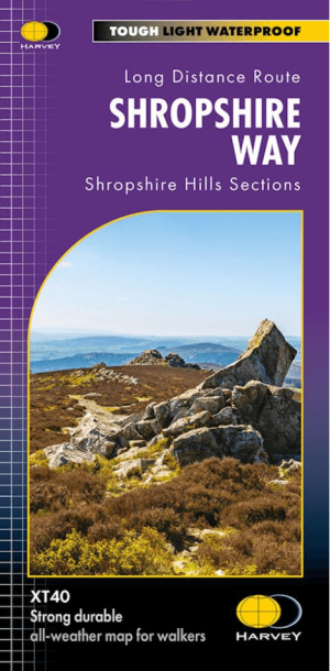
Wandelkaart XT40 The Shropshire Way - Harvey Maps • 9781851376896
Wandelkaart Shropshire Way - Harvey Maps Productomschrijving: Verschillende routes op één kaart! Deze kaart toont de Shropshire Hills, met routes duidelijk aangegeven van de Shropshire Way. Deze kaart beslaat het grootste deel van het Shropshire Hills Area of Outstanding Beauty, waaronder verschillende populaire bergruggen en heuvels: Stiperstones, de Long Mynd, Wenlock Edge, Brown…

Wandelkaart 203 Ludlow Tenbury Wells - OSI • 9780319470756
Wandelkaart Ludlow- Tenbury Wells & Cleobury Mortime Omvat ook: de Shropshire Hills AONB Productbeschrijving: Na de rivier Teme, en met het zuiden van de Shropshire Hills Area of Outstanding Natural Beauty AONB, kunt u onder meer de Hertfordshire Trail en Shropshire Way, verkennen. Ook vindt u de middeleeuwse ommuurde stad van Ludlow en Ludlow kasteel uit de 11e eeuw. De OS Explorer ka…