
Reisgids Oxford & the Cotswolds AONB - Edicola
Cotswolds AONB - Area of Outstanding Natural Beauty
Korte omschrijving
Oxford & the Cotswolds AONB - Edicola Productomschrijving: Wie Oxford zegt, heeft het vaak over de beroemde universiteit. En terecht, de stad en de onderwijsinstelling zijn al eeuwen nauw me...

Specificaties
- Uitgever: Edicola
- ISBN-13: 9789493160446
- HOOFDCATEGORIEËN: Reisgids, Wandelgids
- Activiteiten: Toerisme, Wandelen, Hiking & Trekking
- Auteur: Birte Schohaus
- Regio: Oxfordshire west England
- Land: England
- AONB - Area of Outstanding Beauty: Cotswolds AONB
- Taal: Nederlands
Volledige omschrijving
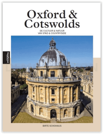
Oxford & the Cotswolds AONB - Edicola
Productomschrijving: Wie Oxford zegt, heeft het vaak over de beroemde universiteit. En terecht, de stad en de onderwijsinstelling zijn al eeuwen nauw met elkaar verbonden. Sterker nog, de universiteit bepaalt grote delen van het stadsbeeld. Overal stuit je op Harry Potter-achtige bibliotheken en zalen, indrukwekkende collegegebouwen en zie je studenten en docenten in vol ornaat over straat lopen.
Maar Oxford is meer dan haar universiteit. De stad heeft een rijke geschiedenis en verschillende levendige wijken. Het is juist het samenspel tussen ‘town and gown’, de stad en de universiteit dus, dat Oxford gemaakt heeft tot wat het is: een levendige stad die uitnodigt om al haar facetten te ontdekken. Direct om de hoek van Oxford beginnen de Cotswolds, een landelijk gebied met kleine, schattige dorpjes, uitgestrekte velden en beroemde herenhuizen en paleizen. Uitgeroepen tot een ‘Area of Outstanding Natural Beauty’ is het beschermde gebied ook onder Britten een gewilde vakantiebestemming. Birte Schohaus is journalist en onderzoeker voor verschillende Nederlandse media, waaronder Follow the Money, NRC Handelsblad en De Groene Amsterdammer. In 2018 verhuisde ze met haar man naar Oxford, waar hij werkt in de wetenschap en zij naast haar journalistieke werk de Engelse cultuur verkend. Samen met hond Boston wordt de omgeving Oxford wandelend verkend
Locatie op kaart
Overzichtskaarten

Area's of Outstanding Natural Beauty - AONB's UK
Area's of Outstanding Natural Beauty - AONB's UK

Producten op de overzichtskaart
Klik op een product om naar de detailpagina te gaan.
- Wandelgids - Guide to the Cotswolds AONB - AA
- Wandelkaart 24 - Chilterns AONB - AA
- Fietskaart- en Mtb kaart - The Cotswolds - Goldeneye
- Wandelgids - Cotswold classic walks guidebook - Goldeneye
- Wandelgids - Exploring the Cotswolds - Goldeneye
- Wandelgids - Cotswold Classic Walks - Goldeneye
- Wandelkaart - Cotswolds- Malverns & Forest of Dean - Goldeneye
- Wandelgids - The Cotswold Way 30 classic routes - Cicerone
- Wandelgids - Kent walking guide - Cicerone
- Wandelgids - North Downs Way Nat. trail - Cicerone
- Wandelgids - Chilterns walking guide - Cicerone
- Wandelgids - Suffolk coast & Heaths walks - Cicerone
- Wandelgids - North Downs Way - Map Booklet - Cicerone
- Wandelgids - North Pennines AONB walking guide - Cicerone
- Wandelgids - Ridgeway National Trail - Cicerone
- Wandelgids - Forest of Bowland & Pendle - Cicerone
- Wandelgids - Hampshire's Test Way walking guide - Cicerone
- Wandelgids & Fietsgids - The Cotswold AONB - Cicerone
- Wandelgids - Walking on the Gower - Cicerone
- Wandelgids - North Wessex Downs - Cicerone Press
- Wandelgids - Walking on the North Wessex Downs - Cicerone
- Wandelgids - Silverdale & Arnside AONB - Cicerone
- Wandelgids - North Downs Way- 246 km - Trailblazer
- Wandelkaart OL2 - Yorkshire Dales- Southern & Western Areas - OSI
- Wandelkaart OL19 - Howgill Fells and Upper Eden Valley - OSI
- Wandelkaart OL21 - South Pennines - Yorkshire - OSI
- Wandelkaart OL31 - North Pennines- Teesdale & Weardale - OSI
- Wandelkaart OL40 - The Broads - OSI
- Wandelkaart OL41 - Forest of Bowland & Ribblesdale - OSI
- Wandelkaart OL45 - The Cotswolds AONB- Gloucestershire - OSI
- Wandelkaart 108 - Lower Tamer Valley & Plymouth- Cornwall- OSI
- Wandelkaart 115 - Exmouth & Sidmouth- Devon - OSI
- Wandelkaart 137 - Ashford- Kent downs AONB- England - OSI
- Wandelkaart 140 - Quantock Hills AONB- Somerset - OSI
- Wandelkaart 140 - Quantock Hills AONB & Bridgwater- Devon - OSI
- Wandelkaart 147 - Sevenoaks & Tonbridge- Kent - OSI
- Wandelkaart 164 - Gower AONB & Gwyr- South Wales - OSI
- Wandelkaart 164 - Gower AONB & Gwyr- Wales - OSI
- Wandelkaart 171 - Chiltern Hills West & Henley-on-Thames OSI
- Wandelkaart 171 - Chiltern Hills West AONB- Wycombe - OSI
- Wandelkaart 172 - Chiltern Hills East AONB- Wycombe - OSI
- Wandelkaart 181 - Chiltern Hills AONB North- England - OSI
- Wandelkaart 181 - Chiltern Hills North AONB- Wycombe - OSI
- Wandelkaart 190 - Malvern Hills & Bredon Hill - OSI
- Wandelkaart 190 - Malvern Hills AONB & Bredon Hill - OSI
- Wandelkaart 203 - Ludlow- Shropshire Hills AONB - OSI
- Wandelkaart 217 - Long Mynd & Wenlock Edge- Schropshire- OSI
- Wandelkaart 254 - Lleyn Peninsular East- North Wales - OSI
- Wandelkaart 261 - Boston- Lincolnshire AONB - OSI
- Wandelkaart 262 - Anglesey West- Wales AONB - OSI
- Wandelkaart 263 - Anglesey East AONB- Wales - OSI
- Wandelkaart 273 - Lincolnshire Wolds South AONB - OSI
- Wandelkaart 282 - Lincolnshire Wolds North AONB - OSI
- Wandelkaart 298 - Nidderdale AONB- Yorkshire - OSI
- Wandelkaart 298 - Nidderdale AONB North Yorkshire - OSI
- Wandelkaart 300 - Howardian Hills AONB - OSI
- Wandelkaart 300 - Howardian Hills AONB & Malton - OSI
- Wandelkaart - Mourne Mountains N. Ireland - Harvey maps
- Wandelkaart - Fietskaart Forest of Bowland - Harvey maps
- Wandelkaart XT40 - Anglesey Coastal Path N. Wales - Harvey Maps
- Wandelkaart XT40 - Pennine Way Noord - Harvey Maps
- Wandelkaart XT40 - Pennine Way Zuid - Harvey Maps
- Wandelgids Cotswold - Way Two-way trekking guide - Knife Edge
- Reisgids Oxford & the Cotswolds AONB - Edicola
- Reisgids Cotswolds England - Rough Guides
- Travelguide Oxford & The Cotswolds pocket guide - Lonely Planet
- Wandelgids - The Ridgeway National trail - Trailblazer
Artikelen uit dezelfde regio
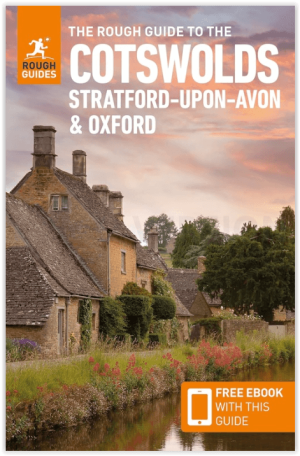
Reisgids Cotswolds AONB - Rough Guides • 9781839059728
The Cotswolds AONB - Rough Guides Productomschrijving: Deze omvat het Cotswolds gebied in zuid-oost Engeland. Een gebied van uitmuntend natuurschoon, of in andere meer lokalere woorden, een AONB area, of Area of Outstanding Natural Beauty. Bij ons is dat bijvoorbeeld de westhoek, het Zwin, enz... Deze reisgids biedt u deze regio inclusief de locaties van Stratford-Uppon-Avon & Oxford die a…

Wandelkaart 170 Abingdon- Wantage & Vale - OSI • 9780319470428
Wandelkaart Abingdon- Wantage & Vale - Oxfordshire England Omvat ook: Wallingford & Faringdon. Productbeschrijving: Kaart nummer 170 in de OS Explorer kaarten reeks heeft betrekking op The Vale of the White Horse, en het paard zelf in Uffington, North Wessex Downs AONB, een verzameling van grote Westenlijke bossen en een klein deel van de Chiltern Hills AONB. Ook zijn de nederzettingen…

Fietskaart 02 Cotswold AONB cycling map - Goldeneye • 9781859653036
Fietskaart Cotswold cycling map - Goldeneye Productomschrijving: De Cotswolds zijn een AONB regio, een regio van uitmuntend natuurschoon. In Engeland geklasseerd als AONB, Area of Outstanding Natural Beauty. Zo heeft de UK er een pak verdeeld over het land. De Cotswold kun je een beetje vergelijken met Cornwall, maar dan zonder de kustlijnen. Hier vindt je prachtige landschappen en trails …

Wandelkaart 164 Oxford & Chipping Norton- England - OSI • 9780319262627
Wandelkaart Oxford- Chipping Norton & Bicester - England Productbeschrijving: Oxford is voorzien van een culturele hoogstanding als gevolg van het wereld beroemde hogeschool, met rijke geschiedenis en familiale uitdagingen. OS Landranger kaart 164 heeft betrekking op de 'stad van de droomtorens en het omliggende gebied. Neem een wandeling langs de rivier de Cherwell, en de botanische tuine…

Fietskaart & Mtb kaart The Cotswolds - Goldeneye • 9781859652589
Fietskaart en Mtb kaart - The Cotswolds - Goldeneye Productomschrijving: De Cotswolds is een AONB streek, (Area of Outstanding Natural Beauty) in centraal Engeland. Het gebied omvat de graafschappen Somerset, Warwickshire, Wiltshire, Oxfordshire & Worcestershire, maar het grootste deel ligt in Gloucestershire. Er wordt sinds eeuwen kalksteen uit de steengroeven gewonnen in deze regio, en d…