

Wandelgids - North Downs Way - Map Booklet - Cicerone
208 km over de North Downs Way - tussen Farnham en Dover


Korte omschrijving
Wandelkaarten South & South East England, Surrey South England, Dover, England, Kent South East England en Farnham, Engeland van CICERONE Press. Ideaal voor tochten in England.
Wandelgids - North Downs Way - Map Booklet - Cicerone Productomschrijving: Kaart van de 208km, over de North Downs Way National Trail, tussen Farnham en Dover, met inbegrip van een optioneel...

Specificaties
- Uitgever: CICERONE Press
- ISBN-13: 9781852849559
- HOOFDCATEGORIEËN: Wandelkaart
- Activiteiten: Wandelen, Hiking & Trekking
- Auteur: Kevin Renolds
- Regio: Dover, England, Farnham, Engeland, Kent South East England, South & South East England, Surrey South England
- Land: England
- Lange afstand wandelroutes: North Downs Way (246 km)
- AONB - Area of Outstanding Beauty/National Landscape: Kent Downs AONB, Surrey Hills AONB
- Schaal: 1:25000
- Editie: 1
- Taal: Engels
- Reeks/Serie: Map Booklet, Cicerone
- National Trails UK, England & Wales: North Downs Way, England
Volledige omschrijving
Wandelgids - North Downs Way - Map Booklet - Cicerone
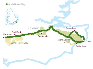
Productomschrijving: Kaart van de 208km, over de North Downs Way National Trail, tussen Farnham en Dover, met inbegrip van een optioneel bezoek aan Canterbury. Dit boekje is opgenomen in de Cicerone gids en toont het volledige parcours op OS 1: 25.000 kaarten. Een van de eenvoudigere nationale routes, dat comfortabel kan worden gelopen in 11-12 dagen.
Product decription: Map of the 130 mile (208km) North Downs Way National Trail, between Farnham and Dover, including an optional visit to Canterbury. This booklet is included with the Cicerone guidebook to the trail and shows the full route on OS 1:25,000 maps. One of the easier National Trails, it can be comfortably walked in 11-12 days.
Seasons:
The North Downs Way can be walked at any time of the year, but is seen at its best between April and October.
Centres:
Beginning in Farnham, the North Downs Way passes close to or through Guildford, Otford, Wrotham, Detling, Charing, Wye, Chilham, Canterbury and Patrixbourne and ends in Dover.
Difficulty:
Despite some reasonably short steep ascents and descents, the North Downs Way is one of the more gentle of National Trails and is suitable for first-time long-distance walkers.
Must See:
Passing through the Surrey and Kent Downs Areas of Outstanding Natural Beauty, the North Downs Way crosses Box Hill, visits Neolithic sites like the Coldrum Stones and Kits Coty House, passes below the remains of Thurnham Castle, visits Canterbury Cathedral and Dover Castle, and wanders across Shakespeare Cliff, one of the White Cliffs of Dover.
Locatie op kaart
Gekoppelde artikelen

Wandelgids - North Downs Way Nat. trail - Cicerone • 9781852848613
standaard versieWandelgids North Downs Way Nat. trail - Cicerone Productomschrijving: Een wandelgids over de North Downs Way nationale Trail, een parcours van de 130 mijl (208km) tussen Farnham en Dover, met een optioneel bezoek aan de Canterbury. Naar aanleiding van de grotendeelse oude pelgrimsroute, door aangenaam platteland, dit is een van de éénvoudigere nationale routes waar de wandeling over 11 eta…
Overzichtskaarten

Area's of Outstanding Natural Beauty - AONB's UK
Area's of Outstanding Natural Beauty - AONB's UK

Producten op de overzichtskaart
Klik op een product om naar de detailpagina te gaan.
- Wandelgids - Guide to the Cotswolds AONB - AA
- Wandelkaart 24 - Chilterns AONB - AA
- Wandelgids - Cotswold classic walks guidebook - Goldeneye
- Wandelgids - Cotswold Classic Walks - Goldeneye
- Wandelgids - The Cotswold Way 30 classic routes - Cicerone
- Wandelgids - North Downs Way Nat. trail - Cicerone
- Wandelgids - Chilterns walking guide - Cicerone
- Wandelgids - Suffolk coast & Heaths walks - Cicerone
- Wandelgids - North Downs Way - Map Booklet - Cicerone
- Wandelgids - North Pennines AONB walking guide - Cicerone
- Wandelgids - Ridgeway National Trail - Cicerone
- Wandelgids - Forest of Bowland & Pendle - Cicerone
- Wandelgids - Hampshire's Test Way walking guide - Cicerone
- Wandelgids & Fietsgids - The Cotswold AONB - Cicerone
- Wandelgids - North Wessex Downs - Cicerone Press
- Wandelgids - Walking on the North Wessex Downs - Cicerone
- Wandelgids - Silverdale & Arnside AONB - Cicerone
- Wandelkaart OL2 - Yorkshire Dales- Southern & Western Areas - OSI
- Wandelkaart OL19 - Howgill Fells and Upper Eden Valley - OSI
- Wandelkaart OL21 - South Pennines - Yorkshire - OSI
- Wandelkaart OL31 - North Pennines- Teesdale & Weardale - OSI
- Wandelkaart OL40 - The Broads - OSI
- Wandelkaart OL41 - Forest of Bowland & Ribblesdale - OSI
- Wandelkaart OL45 - The Cotswolds AONB- Gloucestershire - OSI
- Wandelkaart 108 - Lower Tamer Valley & Plymouth- Cornwall- OSI
- Wandelkaart 115 - Exmouth & Sidmouth- Devon - OSI
- Wandelkaart 137 - Ashford- Kent downs AONB- England - OSI
- Wandelkaart 140 - Quantock Hills AONB- Somerset - OSI
- Wandelkaart 140 - Quantock Hills AONB & Bridgwater- Devon - OSI
- Wandelkaart 147 - Sevenoaks & Tonbridge- Kent - OSI
- Wandelkaart 164 - Gower AONB & Gwyr- South Wales - OSI
- Wandelkaart 164 - Gower AONB & Gwyr- Wales - OSI
- Wandelkaart 171 - Chiltern Hills West & Henley-on-Thames OSI
- Wandelkaart 171 - Chiltern Hills West AONB- Wycombe - OSI
- Wandelkaart 172 - Chiltern Hills East AONB- Wycombe - OSI
- Wandelkaart 181 - Chiltern Hills AONB North- England - OSI
- Wandelkaart 181 - Chiltern Hills North AONB- Wycombe - OSI
- Wandelkaart 190 - Malvern Hills & Bredon Hill - OSI
- Wandelkaart 190 - Malvern Hills AONB & Bredon Hill - OSI
- Wandelkaart 203 - Ludlow- Shropshire Hills AONB - OSI
- Wandelkaart 217 - Long Mynd & Wenlock Edge- Schropshire- OSI
- Wandelkaart 254 - Lleyn Peninsular East- North Wales - OSI
- Wandelkaart 261 - Boston- Lincolnshire AONB - OSI
- Wandelkaart 262 - Anglesey West- Wales AONB - OSI
- Wandelkaart 263 - Anglesey East AONB- Wales - OSI
- Wandelkaart 273 - Lincolnshire Wolds South AONB - OSI
- Wandelkaart 282 - Lincolnshire Wolds North AONB - OSI
- Wandelkaart 298 - Nidderdale AONB- Yorkshire - OSI
- Wandelkaart 298 - Nidderdale AONB North Yorkshire - OSI
- Wandelkaart 300 - Howardian Hills AONB - OSI
- Wandelkaart 300 - Howardian Hills AONB & Malton - OSI
- Wandelkaart - Mourne Mountains N. Ireland - Harvey maps
- Wandelkaart - Fietskaart Forest of Bowland - Harvey maps
- Wandelkaart XT40 - Anglesey Coastal Path N. Wales - Harvey Maps
- Wandelkaart XT40 - Pennine Way Noord - Harvey Maps
- Wandelkaart XT40 - Pennine Way Zuid - Harvey Maps
- Wandelgids Cotswold - Way Two-way trekking guide - Knife Edge
- Reisgids Cotswolds England - Rough Guides
Artikelen uit dezelfde regio

Fietsgids Cycling in Surrey England - Bradt Travel guides • 9781804691359
Cycling in Surrey - Bradt Travel guides Productomschrijving: De nieuwe fietsgids voor Surrey - is onderdeel van een groeiende serie ontworpen voor in de zadeltas - biedt 21 routes, elk inclusief uitgebreide routebeschrijvingen plus contextuele verkenning van geschiedenis, natuur en cultuur, geschreven door fervent fietser en historicus Ross Hamilton. Elke route is gekoppeld aan OS Explorer…

Fietsgids 20 Rides in South East England - Cicerone • 9781852847432
Cycle the best Sportive routes in South East England Productomschrijving: Deze gids biedt 20 sportieve wielerroutes in de meest uitdagende en mooie fietsgebieden van Zuidoost-Engeland. Van Surrey en de Chiltern Hills naar het New Forest en de Berkshire Downs, het gebied heeft km's van fietsvriendelijke wegen geschikt voor sportieve training. De gesorteerde routes zijn allemaal op rustige l…
Wandelgids - Chilterns walking guide - Cicerone • 9781786310187
Wandelgids - Chilterns walking guide - Cicerone Productomschrijving: Deze plaats werd geklasseerd als gebied van uitmuntende schoonheid, of in Engelse termen beter gezegd, een "Area of Oustanding Natural Beauty". Gelegen ten westen van de hoofdstad lonon is dit een soort getaway voor de londonaars die de stad even moe zijn, en de natuur willen opsnuiven. Steve Davison, is de auteur die dez…

Wandelgids Cheddar & the Mendips - 15 short walks - Cicerone • 9781786312549
Wandelgids 15 short walks Cheddar & the Mendips - Cicerone Productomschrijving: Would you like to explore the best of Cheddar and the Mendips? This guidebook covers 15 of the best short walks in the area (between 3 and 10km, all under three hours), including Crook Peak and King's Wood, Beacon Batch and Velvet Bottom, Ebbor Gorge and Ebbor Wood, Cheddar Gorge North and Piney Sleights and th…

Reisgids Zuid-Engeland - Lannoo • 9789401458290
Reisgids - Zuid-Engeland - Lannoo Productomchrijving: De onmisbare gids voor echte trotters - Zuid-Engeland, de streek die je als eerste tegenkomt als je in Dover van de ferry afrijd. De streeks heeft in het miiden een AONB plaats liggen, een Area of Outstanding Natural Beauty, of een gebied van uitmund natuurschoon. De aangegeven plaatsen in deze gids zijn stuk voor stuk gevuld tot aan de…