
HOOFDCATEGORIEËN
Activiteiten
Auteur:
Land
Regio
Reeks/Serie:
Taal
Schaal
Lange afstand wandelroutes
Nationale parken
Regionale parken
TOPO's & Stafkaarten
De Engelse Graafschappen
Grote Eilanden
Iconische Bergketens van Europa
Iconische Wandelroutes
Historische wandelroutes
National Trails UK, England & Wales
De Nationale Parken
De Schotse Munro's
Uitgever
Ordnance Survey bij Bibliotrek
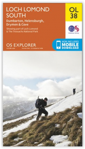
Wandelkaart OL38 Loch Lomond South & Dumbarton - OSI • 9780319242773
Wandelkaart Loch Lomond South & Dumbarton Productomschrijving: Loch Lomond is een groot in Schotland. Het bevindt zich in het westen van de zuidelijke Highlands. Het meer is 37 km lang. Loch Lomond is het grootste meer van Schotland na Loch Ness. In het meer bevinden zich vele eilandjes. Het vormt het centrum van het Nationaal park Loch Lomond en de Trossachs. Een kaart dus die u alles gee…
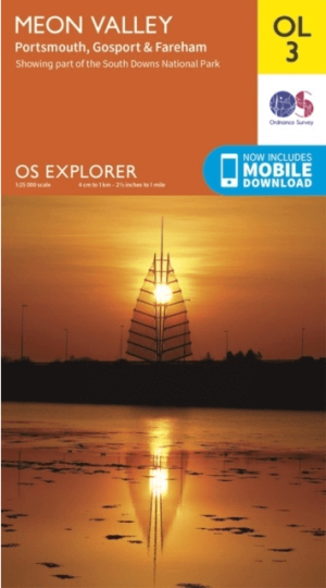
Wandelkaart OL03 Meon Valley Portsmouth - OS • 9780319242421
Meon Valley Portsmouth, Hampshire England - OS Productomschrijving: Meon Valley Portsmouth, Gosport & Fareham areas. Omvat: Meon Valley Portsmouth, Gosport & Fareham areas Hampshire England, Fareham, Waterlooville, Droxford and Owslebury. The south westerly section of the South Downs National Park. South Downs Trail, Solent Way, Kings Way, Pilgrim's Trail and Wayfarers Walk Ontdek…

Wandelkaart OL08 Chichester- South Harting & Selsey - OS • 9780319242476
Wandelkaart Chichester- South Harting & Selsey - OS Productomschrijving: The South Downs National Park, West Sussex England, Chichester- South Harting & Selsey. Omvat: Emsworth, Havant, Horndean, Midhurst and Wittering. Highlights of the area include: Hayling Island, Selsey Bill, Chichester Harbour, Sussex Downs, East Hampshire, and South Downs Way National trail! Ontdek de OL-seri…
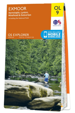
Wandelkaart OL09 Exmoor NP Devon England - OS • 9780319242483
Wandelkaart Exmoor NP Devon England - OS Productomschrijving: Exmoor National Park, Devon England Omvat: Exmoor National Park, Devon England, Barnstaple, Lynton, Minehead & Dulverton. Ontdek de OL-serie van Ordnance Survey: De OL-serie (Outdoor Leisure) van Ordnance Survey is dé referentie voor wie gaat wandelen op de Britse eilanden. Deze topografische kaarten maken deel uit va…

Wandelkaart OL10 Arundel- Pulborough & Worthing - OS • 9780319242490
Wandelkaart Arundel- Pulborough & Worthing - OS Productomschrijving: South Downs National Park West Sussex England, & the coastline between Bognor Regis and Worthing and the town of Arundel. Omvat: Also the River Arun, Monarch's Way and part of the South Downs Way. Ontdek de OL-serie van Ordnance Survey: De OL-serie (Outdoor Leisure) van Ordnance Survey is dé referentie voor wie …
Wandelkaart OL012 Brecon Beacons Nat. Parc West & Central areas • 9780319242513
Wandelkaart Brecon Beacons National Parc West & Centre Productomschrijving: Brecon Beacons National Parc Western & Central area. Parc Cenedlaethol Bannau Brycheiniog. Ontdek de OL-serie van Ordnance Survey: De OL-serie (Outdoor Leisure) van Ordnance Survey is dé referentie voor wie gaat wandelen op de Britse eilanden. Deze topografische kaarten maken deel uit van de Explorer-reeks en…
Wandelkaart OL013 Brecon Beacons National Parc East - OS • 9780319242520
Wandelkaart Brecon Beacons National Parc East - OS Productomschrijving: Brecon Beacons National Parc Eastern Area. Omvat: Brecon Beacons National Parc Eastern Area, Parc Cenedlaethol Bannau Brycheiniog (Ardal ddwyreiniol) Ontdek de OL-serie van Ordnance Survey: De OL-serie (Outdoor Leisure) van Ordnance Survey is dé referentie voor wie gaat wandelen op de Britse eilanden. Deze to…

Wandelkaart OL15 Purbeck & South Dorset - OS • 9780319242544
Wandelkaart Purbeck & South Dorset - OS Productomschrijving: Parts of the South West Coast Path SWCP, Dorset Area of Outstanding Natural Beauty. Omvat: Purbeck, South Dorset, Poole, Dorchester, Weymouth & Swanage, Castleman Trailway, E9 European Coastal parth, England Coast Path, Hardy Way, Jubilee Trail, Macmillan Way, Monarch's Way, Poole Harbour Trail, Portland Coast Path, Purbeck …
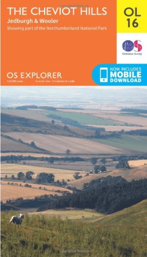
Wandelkaart OL16 Cheviot Hills, Jedburgh & Wooler - OS • 9780319242551
Wandelkaart Cheviot Hills, Jedburgh & Wooler - OS Productomschrijving: Cheviot Hills, Jedburgh & Wooler, part of Northumberland Natioal Park. Omvat: Cheviot Hills, Jedburgh & Wooler, part of Northumberland Natioal Park, Pennine Way, E2 European long Distance Path, Borders Abbeys Way & St-Cuthbert's Way. Ontdek de OL-serie van Ordnance Survey: De OL-serie (Outdoor Leisure) van Ord…
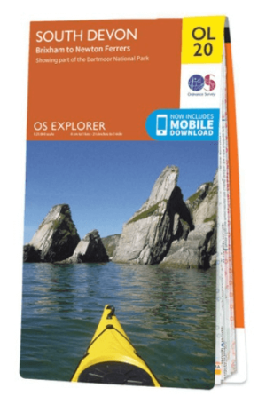
Wandelkaart OL20 South Devon & Dartmoor NP - OS • 9780319242599
Wandelkaart South Devon - OS Productomschrijving: South Devon, Dartmoor National Park and parts of the South West Coast Path SWCP, South Devon AONB and Tamar Valley AONB. Omvat: Brixham to Newton Ferrers, Avon Estuary Walk, Co-operative Way, Dart Valley Trail, E9 European Long Distanse Path, Erme-Plym Trail, Greenway Walk, John Musgrave Heritage Trail, Plymouth Cross-City Link, South …
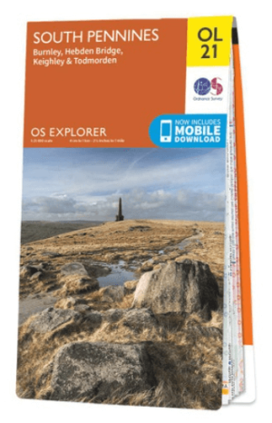
Wandelkaart OL21 South Pennines - OS • 9780319242605
Wandelkaart South Pennines - Ordnance Survey Productomschrijving: Parts of the Peak District National Park, South Pennines, Brontë Way, Burnley Way, Calder / Aire Link, Calderdale Way, Colne Valley Circular Walk, Dales High Way, E2 European long distance Path, Irwell Sculpture trail, Kirklees Way, Meltham Way, Millenium Way, Oldhan Way & Crompton Circuit, Pendle Way, Pennine Bridleway, Pen…
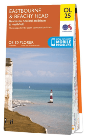
Wandelkaart OL25 Eastbourne & Beachy Head - OS • 9780319242643
Wandelkaart Eastbourne & Beachy Head - OS Productomschrijving: Eastbourne & Beachy Head Omvat: Newhaven, Seaford, Hailsham & Heathfield, Uckfield, the High Weald AONB, South Downs National Park, South Downs Way, Cuckmere Haven, River Cucksmereand the 1066 Country Walk. Ontdek de OL-serie van Ordnance Survey: De OL-serie (Outdoor Leisure) van Ordnance Survey is dé referentie voor …
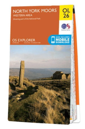
Wandelkaart OL26 North York Moors Western area - OS • 9780319242650
Wandelkaart North York Moors, Western area - OS Productomschrijving: Een topografische wandelkaart van het westerse deel van het North York Moors National Park. Omvat: Het Howardian Hills AONB gebied, deel van het nationale park van de North York Moors, Tees Forest Community Forest, The Cleveland Street Walk, Cleveland Way, E2 European long distance Path, Ebor Way, England Coast PAth, …
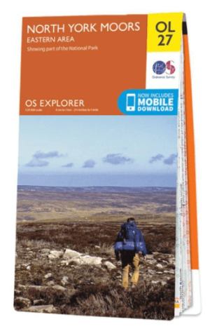
Wandelkaart OL27 North York Moors, Eastern area - OS • 9780319242667
Wandelkaart North York Moors, Eastern area - OS Productomschrijving: North York Moors National Park, Eastern Area, Cleveland Way, Cleveland street Walk, Er European Long Distance Path, England Coast PAth, Esk Valley Walk, North Sea Trail & Tabular Hills Walk. Omvat: The Eastern area of the North York Moors National Park, Yorkshire England. Ontdek de OL-serie van Ordnance Survey: …

Wandelkaart OL31 Northern Pennines AONB, Teesdale & Weardale - OS • 9780319242704
Wandelkaart Northern Pennines, Teesdale & Weardale - OS Productomschrijving: Northern Pennines AONB, Teesdale & Weardale, part of the Pennine Way, Omvat: A pennine Journey, E2 European Long Distance Path, Isaac's Tea Trail, Pennine Way, South Tyne Trail, Tees Railway Path, Teesdale Way & Weardale Way. Ontdek de OL-serie van Ordnance Survey: De OL-serie (Outdoor Leisure) van Ordn…

Wandelkaart OL32 Winchester, New Alresford & East Meon - OS • 9780319242711
Wandelkaart Winchester, New Alresford & East Meon - OS Productomschrijving: Winchester, New Alresford & East Meon Omvat: The South Downs Way, Winchester Cathedral, The River Itchen, and The Jane Austen Trail. Ontdek de OL-serie van Ordnance Survey: De OL-serie (Outdoor Leisure) van Ordnance Survey is dé referentie voor wie gaat wandelen op de Britse eilanden. Deze topografische k…

Wandelkaart OL33 Haslemere & Petersfield - OS • 9780319242728
Wandelkaart Haslemere & Petersfield - OS Productomschrijving: Haslemere, Petersfield, Midhurt & Selborne. Omvat: Haslemere, Petersfield, Midhurst and Selborne, South Downs National Park, Surrey Hills and the Sussex Border Path, Greensand Way, Hangers Way, the River Rother and New Lipchis Way Ontdek de OL-serie van Ordnance Survey: De OL-serie (Outdoor Leisure) van Ordnance Surve…

Wandelkaart OL33 Haslemere & Petersfield - OS • 9780319242735
Wandelkaart Crawley & Horsham - Ordnance Survey Productomschrijving: Crawley, Horsham, Cranleigh, Billinghurst & part of the South Downs National Park. Omvat: Crawley, Horsham, Cranleigh, Billinghurst, The AONB regions of the Surrey Hills and High Weald, part of the South Downs National Park, Downs Link, Greensand Way, High Weald Landscape Trail, Serpent Trail, Sussex Border Path, Sus…

Wandelkaart OL036 Pembrokeshire National Park South - OS • 9780319242759
Wandelkaart Pembrokeshire National Park South - OS Productomschrijving: Pembrokeshire National Park South Ontdek de OL-serie van Ordnance Survey: De OL-serie (Outdoor Leisure) van Ordnance Survey is dé referentie voor wie gaat wandelen op de Britse eilanden. Deze topografische kaarten maken deel uit van de Explorer-reeks en bieden ongeëvenaarde nauwkeurigheid en detail op een schaal …

Wandelkaart OL37 Cowal East- Dunoon & Iverary - OS • 9780319242766
Wandelkaart Cowal East- Dunoon & Iverary - OS Productomschrijving: Cowal East- Dunoon & Iverary, & Part of Loch Lomond & The Trossachs National Part. Omvat: Cowal East- Dunoon & Iverary, & Part of Loch Lomond & The Trossachs National Part, Argyll Forest Park, Kyles of Bute National Scenic Area, Cowal Way & the West Island Way. Ontdek de OL-serie van Ordnance Survey: De OL-serie (…
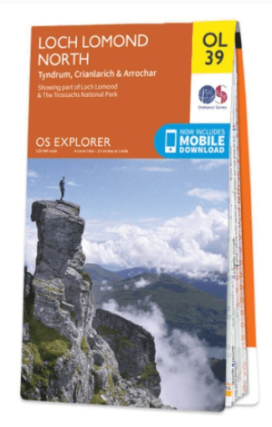
Wandelkaart OL39 Loch Lomond North & Tyndrum - OS • 9780319242780
Wandelkaart Loch Lomond North & Tyndrum - OS Productomschrijving: Loch Lomond North & Tyndrum, Crianlarich & Arrochar, part of Loch Lomond & The Trossachs National Park. Omvat: Loch Lomond North & Tyndrum, Crianlarich & Arrochar, part of Loch Lomond & The Trossachs National Park. Ontdek de OL-serie van Ordnance Survey: De OL-serie (Outdoor Leisure) van Ordnance Survey is dé refe…

Wandelkaart OL41 Forest of Bowland & Ribblesdale - OS • 9780319242803
Wandelkaart Forest of Bowland AONB & Ribblesdale - OS Productomschrijving: Pendle Hill- Clitheroe & Settle - Yorkshire Dales NP, A pennine Journey, Dales High Way, Lancashire Coastal Way, Line Valley Ramble, Pendle Way, Pennine bridleway, Ribble Way & Wyre Way. Omvat: Pendle Hill- Clitheroe & Settle - parts of the Yorkshire Dales NP, Ontdek de OL-serie van Ordnance Survey: De O…
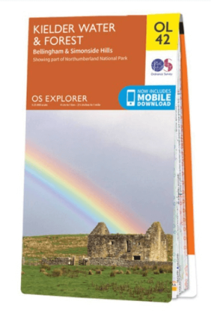
Wandelkaart OL42 Kielder Water & Forest - OS • 9780319242810
Wandelkaart Kielder Water & Forest - OS Productomschrijving: Kielder Water & Forest, Bellingham & Simonside Hills, part of Northumberland National Park, Pennine Way, St Oswald's Way, Lakeside Way & E2 European long distance Path. Omvat: Kielder Water & Forest, Bellingham & Simonside Hills Ontdek de OL-serie van Ordnance Survey: De OL-serie (Outdoor Leisure) van Ordnance Survey i…

Wandelkaart OL44 Torquay, Dawlish & Newton Abbot - OS • 9780319242834
Wandelkaart Torquay, Dawlish & Newton Abbot - OS Productomschrijving: parts of Dartmoor National Park & Parts of the South West Coast Path. Omvat: Torquay, Dawlish & Newton Abbot, E9 European Coastal Path, East Devon Way, Exe Valley Way, John Musgrave Heritage Way, Parts of the South West Coast Path SWCP, Templer Way & The Torbay-Totnes trail. Ontdek de OL-serie van Ordnance Surve…

Wandelkaart OL45 The Cotswolds AONB - OS • 9780319242841
Wandelkaart The Cotswolds AONB - OS Productomschrijving: Wychwood Community Forest, The Centenary Way, Cotswolds Way, D'Arcy Dalton Way, Diamond Way, E2 European Long Distance Path, Gloucestershire Way, Heart of England Way, Macmillan Way, Monarch's Way, Oxfordshire Way, Thames Path, Shakespeare Way, Warden's Way, Winchcombe Way, Windrush Way & Wychavon Way. Omvat: Burford, Chipping C…