

Wandelkaart OL20 South Devon & Dartmoor NP - OS
South Devon- Dartmoor National Park- parts of the SWCP


Korte omschrijving
Wandelkaarten Devon, England van Ordnance Survey. Ideaal voor tochten in England.
Wandelkaart South Devon - OS Productomschrijving: South Devon, Dartmoor National Park and parts of the South West Coast Path SWCP, South Devon AONB and Tamar Valley AONB. Omvat: Brixham...

Specificaties
- Uitgever: Ordnance Survey
- ISBN-13: 9780319242599
- HOOFDCATEGORIEËN: Wandelkaart
- Activiteiten: Wandelen, Hiking & Trekking
- Auteur: Ordnance Survey
- Regio: Devon, England
- Land: England
- Lange afstand wandelroutes: South West Coast Path - SWCP (1014 km)
- Nationale parken: Dartmoor NP, Devon England
- TOPO's & Stafkaarten: Topografisch wandelen
- AONB - Area of Outstanding Beauty/National Landscape: South Devon, AONB, Tamar Valley AONB
- Schaal: 1:25000
- Taal: Engels
- Reeks/Serie: Explorer Series OS
- Iconische Wandelroutes: South West coast Path, Cornwall UK
- De Engelse Graafschappen: Devon
Volledige omschrijving
Wandelkaart South Devon - OS
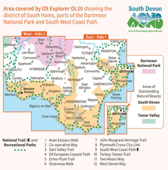
Productomschrijving: South Devon, Dartmoor National Park and parts of the South West Coast Path SWCP, South Devon AONB and Tamar Valley AONB.
Omvat: Brixham to Newton Ferrers, Avon Estuary Walk, Co-operative Way, Dart Valley Trail, E9 European Long Distanse Path, Erme-Plym Trail, Greenway Walk, John Musgrave Heritage Trail, Plymouth Cross-City Link, South West Coast Path SWCP, Torbay-Totnes Trail, Two Moors Way & West Devon Way.
Ontdek de OL-serie van Ordnance Survey:
De OL-serie (Outdoor Leisure) van Ordnance Survey is dé referentie voor wie gaat wandelen op de Britse eilanden. Deze topografische kaarten maken deel uit van de Explorer-reeks en bieden ongeëvenaarde nauwkeurigheid en detail op een schaal van 1:25.000. Perfect voor wandelaars, hikers en outdoorliefhebbers.
Waarom kiezen voor de OL Explorer-kaarten?
Gedetailleerde topografie: Elk hekje, pad, beekje en hoogteverschil staat erop.
Ingetekende National Trails: Bekende wandelroutes zoals de South West Coast Path, Hadrian’s Wall Path en Pennine Way zijn duidelijk gemarkeerd.
Betrouwbaarheid: Ordnance Survey is al decennialang de standaard voor kaarten in het VK.
Weerbestendige versies beschikbaar – ideaal voor gebruik in weer en wind.
De beste keuze voor wandelaars
Vergeet generieke wandelkaarten. Met de OL-serie krijg je precieze, actuele informatie, zodat je zonder zorgen op pad kunt.
KOOP NU UW TOPOGRAFISCHE WANDELKAART
Bekijk ons aanbod en kies de OL-kaart die past bij jouw volgende wandelroute. Wandel slim, wandel met Ordnance Survey. wandelroute. Wandel slim, wandel met Ordnance Survey.
Overzichtskaarten

OSI Explorer & Explorer Active - Z.W. England Devon - Cornwall
OSI Explorer & Explorer Active - Z.W. England Devon - Cornwall

Producten op de overzichtskaart
Klik op een product om naar de detailpagina te gaan.
- Wandelkaart 102 Land's End - OSI
- Wandelkaart 102 Land's End - OSI
- Wandelkaart 103 The Lizard- Cornwall England - OSI
- Wandelkaart 103 The Lizard- Cornwall England - OSI
- Wandelkaart 104 Redruth & St Agnes- Cornwall - OSI
- Wandelkaart 104 Redruth & St Agnes- Cornwall - OSI
- Wandelkaart 105 Falmouth & Mevagissey - Cornawall - OSI
- Wandelkaart 106 Newquay & Padstow - Cornwall - OSI
- Wandelkaart 107 St-Austell & Liskeard- Cornwall - OSI
- Wandelkaart 108 Lower Tamar Valley & Plymouth - OSI
- Wandelkaart 109 Bodmin Moor- Cornwal - OSI
- Wandelkaart 111 Bude- Boscastle & Tintagel- Devon - OSI
- Wandelkaart 112 Launceston & Holsworthy- Devon - OSI
- Wandelkaart 113 Okehampton- Devon England - OSI
- Wandelkaart 113 Okehampton- Devon England - OSI
- Wandelkaart 114 Exeter & Exe Valley- Devon - OSI
- Wandelkaart 114 Exeter & Exe Valley- Devon - OSI
- Wandelkaart 115 Exmouth & Sidmouth- Devon - OSI
- Wandelkaart 115 Exmouth & Sidmouth- Devon - OSI
- Wandelkaart 116 Lyme regis & Bridport- Devon - OSI
- Wandelkaart 116 Lyme Regis & Bridport- Dorset - OSI
- Wandelkaart 117 Cerne Abbas & Bere Regis - Dorset - OSI
- Wandelkaart 117 Cerne Abbas & Bere Regis - Dorset - OSI
- Wandelkaart OL15 Purbeck- South Dorset & Poole - OSI
- Wandelkaart 118 Shaftesbury & Cranbourne Chase - OSI
- Wandelkaart 118 Shaftesbury & Cranbourne Chase - OSI
- Wandelkaart 129 Yeovil & Sherborne- Somerset - OSI
- Wandelkaart 129 Yeovil & Sherborne- Somerset - OSI
- Wandelkaart 140 Quantock Hills AONB & Bridgwater- Devon - OSI
- Wandelkaart 140 Quantock Hills AONB- Somerset - OSI
- Wandelkaart 141 Cheddar Gorge & Mendip Hills - OSI
- Wandelkaart 141 Shepton Mallet & Mendip Hills East - OSI
- Wandelkaart 142 Shepton Mallet & Mendip Hills - OSI
- Wandelkaart 142 Shepton Mallet & Mendip Hills - OSI
- Wandelkaart 143 Warminster & Trowbridge- Wiltshire - OSI
- Wandelkaart 143 Warminster & Trowbridge- Wiltshire - OSI
- Wandelkaart 130 Salisburry & Stonehenge- Wiltshire - OSI
- Wandelkaart 130 Salisburry & Stonehenge- Wiltshire - OSI
- Wandelkaart 131 Romsey- Andover & Test Valley- Hampshire
- Wandelkaart 131 Romsey & Andover - Hampshire - OSI
- Wandelkaart 153 Weston-super-Mare & Bleadon Hill - OSI
- Wandelkaart 153 Weston-Super-Mare & Bleadon Hill - OSI
- Wandelkaart 154 Bristol West & Portishead- Bristol - OSI
- Wandelkaart 154 Bristol West & Portishead- Bristol area
- Wandelkaart 155 Bristol & Bath Keynsham & Marshfield - OSI
- Wandelkaart 155 Bristol & Bath- Bristol Area - OSI
- Wandelkaart 156 Chippenham & Bradford-on-Avon - OSI
- Wandelkaart 156 Chippenham & Bradford-on-Avon- Wiltshire - OSI
- Wandelkaart 157 Marlborough & Savernake Forest - OSI
- Wandelkaart 157 Marlborough & Savernake Forest - OSI
- Wandelkaart 158 Newbury & Hungerford- Berkshire - OSI
- Wandelkaart 158 Newbury & Hungerford- West Berkshire - OSI
- Wandelkaart 167 Thornbury- Dursley & Yate - England- OSI
- Wandelkaart 167 Thornbury- Dursley & Yate - England- OSI
- Wandelkaart 168 Stroud- Tetbury & Malmesbury - OSI
- Wandelkaart 168 Stroud- Tetbury & Malmesbury - OSI
- Wandelkaart 169 Cirencester & Swindon - England - OSI
- Wandelkaart 169 Cirencester & Swindon - England - OSI
- Wandelkaart 170 Abingdon & Wantage - Oxfordshire - OSI
- Wandelkaart 170 Abingdon- Wantage & Vale - OSI
- Wandelkaart 179 Gloucester- Cheltenham & Stroud - OSI
- Wandelkaart 205 Stratford-upon-Avon & Evesham - OSI
- Wandelkaart 205 Stratford-upon-Avon & Evesham - OSI
- Wandelkaart 206 Edge Hill & Fenny Compton - OSI
- Wandelkaart 206 Edge Hill & Fenny Compton - OSI
- Wandelkaart OL09 Exmoor NP Devon England - OS
- Wandelkaart OL15 Purbeck & South Dorset - OS
- Wandelkaart OL20 South Devon & Dartmoor NP - OS
- Wandelkaart OL22 New Forest National Park - OS
- Wandelkaart OL28 Dartmoor National Park - OS
- Wandelkaart OL45 The Cotswolds AONB - OS
Artikelen uit dezelfde regio

Wandelgids SWCP part 3 - Dorset & South Devon - Trailblazer • 9781912716340
Wandelgids SWCP part 3 - Dorset & South Devon - Trailblazer Productomschrijving: Dorset & South Devon Coast Path (South-West Coast Path Part 3) This guide covers the third and last section of the South West Coast Path, from Plymouth to Poole Harbour (217 miles). This beautiful route includes 95 miles within England’s only Natural World Heritage Site, the Jurassic Coast, and passes dram…

Reisgids Slow travel Devon East & Jurassic Coast - Bradt travel • 9781804692738
Reisgids Devon East & Jurassic Coast - Bradt Productomschrijving: Part of Bradt’s distinctive, award-winning series of ‘Slow’ travel guides to UK regions, this updated Bradt East Devon and the Jurassic Coast Guidebook remains the most comprehensive – and only standalone – guide available to this area. Written with insider knowledge that can only be gained by living in the area, and com…

Wandelgids Cornwall & Devon - Rother Bergverlag • 9783763348923
Wandelgids Cornwall & Devon - Rother Productomschrijving: Een schitterende kustlijn, weelderig groene heuvels, uitgestrekte tuinen - dat zijn Cornwall en Devon. Daarnaast heidevelden gedomineerd door bizarre granieten rotsen, woeste ravijnen en steile kliffen. Wandelaars en natuurliefhebbers vinden hier een klein paradijs. Met 53 unieke routesuggesties presenteert de Rother wandelgids “Co…
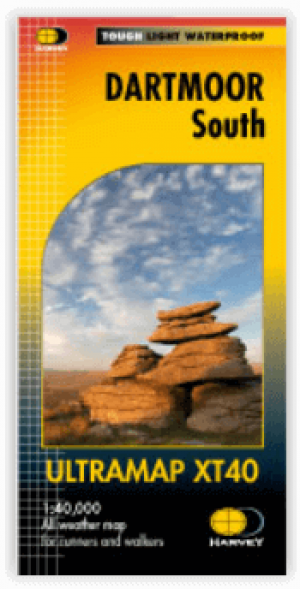
Wandelkaart XT40 Dartmoor NP Zuid - Harvey Maps • 9781851376339
Wandelkaart XT40 Ultra - Dartmoor NP Zuid - Harvey Maps Productomschrijving: De kaart omvat een groot gebied maar is wel zeer praktisch en compact, en in zakformaat. Deze gedetailleerde wandelkaart is bestemd voor lopers en wandelaars van het zuidelijk deel van Dartmoor National Park. Omvat eveneens Dartmoor's bekende Tors waaronder Great Staple Tor & Ugborough Beacon. Met archaeologische …

Wandelgids Walking the Dartmoor way - Cicerone • 9781786311153
Walking the Dartmoor way - Cicerone Productomschrijving: Een gloednieuwe wandelgids van Cicerone over het wandelen van de befaamde Dartmoor Way, een bewegwijzerde wandelroute van 175 km (109 mijl) langs de rand van het prachtige Dartmoor NP in Devon. De route bestaat uit 10 etappes (plus de High Moor Link die kan worden gebruikt om twee kortere lussen te maken) en voert langs beboste valle…