

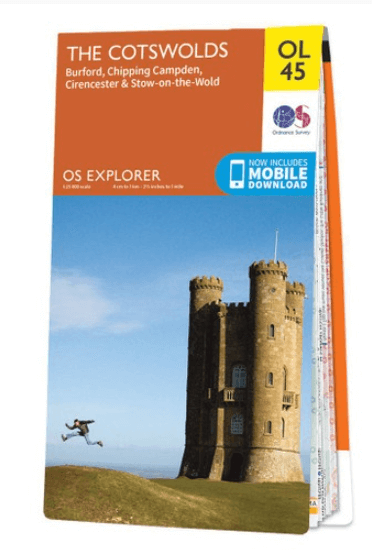
Wandelkaart OL45 The Cotswolds AONB - OS
Burford- Chipping Campden- Cirencester & Stow-on-the-Wold
Korte omschrijving
Wandelkaarten Somerset South West England, Warwickshire, West Midlands, Wiltshire, West England, Oxfordshire west England en Worcestershire, West England van Ordnance Survey. Ideaal voor tochten in England.
Wandelkaart The Cotswolds AONB - OS Productomschrijving: Wychwood Community Forest, The Centenary Way, Cotswolds Way, D'Arcy Dalton Way, Diamond Way, E2 European Long Distance Path, Gloucest...

Specificaties
- Uitgever: Ordnance Survey
- ISBN-13: 9780319242841
- HOOFDCATEGORIEËN: Wandelkaart
- Activiteiten: Wandelen, Hiking & Trekking
- Auteur: Ordnance Survey
- Regio: Oxfordshire west England, Somerset South West England, Warwickshire, West Midlands, Wiltshire, West England, Worcestershire, West England
- Land: England
- Lange afstand wandelroutes: Cotswold Way, England (164km), Thames Path Way (296 km)
- Regionale parken: Wychwood Project Community Forest, England
- TOPO's & Stafkaarten: Topografisch wandelen
- AONB - Area of Outstanding Beauty/National Landscape: Cotswolds AONB
- Schaal: 1:25000
- Taal: Engels
- Reeks/Serie: Explorer Series OS
Volledige omschrijving
Wandelkaart The Cotswolds AONB - OS
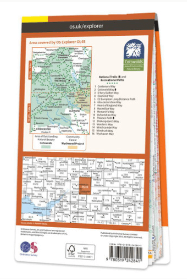
Productomschrijving: Wychwood Community Forest, The Centenary Way, Cotswolds Way, D'Arcy Dalton Way, Diamond Way, E2 European Long Distance Path, Gloucestershire Way, Heart of England Way, Macmillan Way, Monarch's Way, Oxfordshire Way, Thames Path, Shakespeare Way, Warden's Way, Winchcombe Way, Windrush Way & Wychavon Way.
Omvat: Burford, Chipping Campden, Cirencester & Stow-on-the-Wold, The Cotswolds Area of Outstanding Natural Beauty.
Ontdek de OL-serie van Ordnance Survey:
De OL-serie (Outdoor Leisure) van Ordnance Survey is dé referentie voor wie gaat wandelen op de Britse eilanden. Deze topografische kaarten maken deel uit van de Explorer-reeks en bieden ongeëvenaarde nauwkeurigheid en detail op een schaal van 1:25.000. Perfect voor wandelaars, hikers en outdoorliefhebbers.
Waarom kiezen voor de OL Explorer-kaarten?
Gedetailleerde topografie: Elk hekje, pad, beekje en hoogteverschil staat erop.
Ingetekende National Trails: Bekende wandelroutes zoals de South West Coast Path, Hadrian’s Wall Path en Pennine Way zijn duidelijk gemarkeerd.
Betrouwbaarheid: Ordnance Survey is al decennialang de standaard voor kaarten in het VK.
Weerbestendige versies beschikbaar – ideaal voor gebruik in weer en wind.
De beste keuze voor wandelaars
Vergeet generieke wandelkaarten. Met de OL-serie krijg je precieze, actuele informatie, zodat je zonder zorgen op pad kunt.
KOOP NU UW TOPOGRAFISCHE WANDELKAART
Bekijk ons aanbod en kies de OL-kaart die past bij jouw volgende wandelroute. Wandel slim, wandel met Ordnance Survey. wandelroute. Wandel slim, wandel met Ordnance Survey.

Overzichtskaarten

OSI Explorer & Explorer Active - Z.W. England Devon - Cornwall
OSI Explorer & Explorer Active - Z.W. England Devon - Cornwall

Producten op de overzichtskaart
Klik op een product om naar de detailpagina te gaan.
- Wandelkaart 102 Land's End - OSI
- Wandelkaart 102 Land's End - OSI
- Wandelkaart 103 The Lizard- Cornwall England - OSI
- Wandelkaart 103 The Lizard- Cornwall England - OSI
- Wandelkaart 104 Redruth & St Agnes- Cornwall - OSI
- Wandelkaart 104 Redruth & St Agnes- Cornwall - OSI
- Wandelkaart 105 Falmouth & Mevagissey - Cornawall - OSI
- Wandelkaart 106 Newquay & Padstow - Cornwall - OSI
- Wandelkaart 107 St-Austell & Liskeard- Cornwall - OSI
- Wandelkaart 108 Lower Tamar Valley & Plymouth - OSI
- Wandelkaart 109 Bodmin Moor- Cornwal - OSI
- Wandelkaart 111 Bude- Boscastle & Tintagel- Devon - OSI
- Wandelkaart 112 Launceston & Holsworthy- Devon - OSI
- Wandelkaart 113 Okehampton- Devon England - OSI
- Wandelkaart 113 Okehampton- Devon England - OSI
- Wandelkaart 114 Exeter & Exe Valley- Devon - OSI
- Wandelkaart 114 Exeter & Exe Valley- Devon - OSI
- Wandelkaart 115 Exmouth & Sidmouth- Devon - OSI
- Wandelkaart 115 Exmouth & Sidmouth- Devon - OSI
- Wandelkaart 116 Lyme regis & Bridport- Devon - OSI
- Wandelkaart 116 Lyme Regis & Bridport- Dorset - OSI
- Wandelkaart 117 Cerne Abbas & Bere Regis - Dorset - OSI
- Wandelkaart 117 Cerne Abbas & Bere Regis - Dorset - OSI
- Wandelkaart OL15 Purbeck- South Dorset & Poole - OSI
- Wandelkaart 118 Shaftesbury & Cranbourne Chase - OSI
- Wandelkaart 118 Shaftesbury & Cranbourne Chase - OSI
- Wandelkaart 129 Yeovil & Sherborne- Somerset - OSI
- Wandelkaart 129 Yeovil & Sherborne- Somerset - OSI
- Wandelkaart 140 Quantock Hills AONB & Bridgwater- Devon - OSI
- Wandelkaart 140 Quantock Hills AONB- Somerset - OSI
- Wandelkaart 141 Cheddar Gorge & Mendip Hills - OSI
- Wandelkaart 141 Shepton Mallet & Mendip Hills East - OSI
- Wandelkaart 142 Shepton Mallet & Mendip Hills - OSI
- Wandelkaart 142 Shepton Mallet & Mendip Hills - OSI
- Wandelkaart 143 Warminster & Trowbridge- Wiltshire - OSI
- Wandelkaart 143 Warminster & Trowbridge- Wiltshire - OSI
- Wandelkaart 130 Salisburry & Stonehenge- Wiltshire - OSI
- Wandelkaart 130 Salisburry & Stonehenge- Wiltshire - OSI
- Wandelkaart 131 Romsey- Andover & Test Valley- Hampshire
- Wandelkaart 131 Romsey & Andover - Hampshire - OSI
- Wandelkaart 153 Weston-super-Mare & Bleadon Hill - OSI
- Wandelkaart 153 Weston-Super-Mare & Bleadon Hill - OSI
- Wandelkaart 154 Bristol West & Portishead- Bristol - OSI
- Wandelkaart 154 Bristol West & Portishead- Bristol area
- Wandelkaart 155 Bristol & Bath Keynsham & Marshfield - OSI
- Wandelkaart 155 Bristol & Bath- Bristol Area - OSI
- Wandelkaart 156 Chippenham & Bradford-on-Avon - OSI
- Wandelkaart 156 Chippenham & Bradford-on-Avon- Wiltshire - OSI
- Wandelkaart 157 Marlborough & Savernake Forest - OSI
- Wandelkaart 157 Marlborough & Savernake Forest - OSI
- Wandelkaart 158 Newbury & Hungerford- Berkshire - OSI
- Wandelkaart 158 Newbury & Hungerford- West Berkshire - OSI
- Wandelkaart 167 Thornbury- Dursley & Yate - England- OSI
- Wandelkaart 167 Thornbury- Dursley & Yate - England- OSI
- Wandelkaart 168 Stroud- Tetbury & Malmesbury - OSI
- Wandelkaart 168 Stroud- Tetbury & Malmesbury - OSI
- Wandelkaart 169 Cirencester & Swindon - England - OSI
- Wandelkaart 169 Cirencester & Swindon - England - OSI
- Wandelkaart 170 Abingdon & Wantage - Oxfordshire - OSI
- Wandelkaart 170 Abingdon- Wantage & Vale - OSI
- Wandelkaart 179 Gloucester- Cheltenham & Stroud - OSI
- Wandelkaart 205 Stratford-upon-Avon & Evesham - OSI
- Wandelkaart 205 Stratford-upon-Avon & Evesham - OSI
- Wandelkaart 206 Edge Hill & Fenny Compton - OSI
- Wandelkaart 206 Edge Hill & Fenny Compton - OSI
- Wandelkaart OL09 Exmoor NP Devon England - OS
- Wandelkaart OL15 Purbeck & South Dorset - OS
- Wandelkaart OL20 South Devon & Dartmoor NP - OS
- Wandelkaart OL22 New Forest National Park - OS
- Wandelkaart OL28 Dartmoor National Park - OS
- Wandelkaart OL45 The Cotswolds AONB - OS

OSI Explorer & Explorer Active - Zuid Oost England - Kent & London
OSI Explorer & Explorer Active - Zuid Oost England - Kent & London

Producten op de overzichtskaart
Klik op een product om naar de detailpagina te gaan.
- Wandelkaart OL03 Meon Valley Portsmouth - OS
- Wandelkaart OL08 Chichester- South Harting & Selsey - OS
- Wandelkaart OL10 Arundel- Pulborough & Worthing - OS
- Wandelkaart OL11 Brighton- Hove & South Downs NP - OS
- Wandelkaart OL22 New Forest National Park - OS
- Wandelkaart OL25 Eastbourne & Beachy Head - OS
- Wandelkaart OL32 Winchester, New Alresford & East Meon - OS
- Wandelkaart OL29 Isle of Wight & Cowes - OSI
- Wandelkaart OL29 Isle of Wight South East England - OS
- Wandelkaart OL33 Haslemere & Petersfield - OS
- Wandelkaart OL33 Haslemere & Petersfield - OS
- Wandelkaart OL45 The Cotswolds AONB - OS
- Wandelkaart 118 Shaftesbury & Cranbourne Chase - OSI
- Wandelkaart 124 Hastings & Bexhill East Sussex - OSI
- Wandelkaart 124 Hastings & Bexhill East Sussex - OSI
- Wandelkaart 125 Romney Marsh Rye & Winchelsea - OSI
- Wandelkaart 130 Salisburry & Stonehenge- Wiltshire - OSI
- Wandelkaart 131 Romsey & Andover - Hampshire - OSI
- Wandelkaart 135 Ashdown Forest - East Sussex - OSI
- Wandelkaart 136 High Weald Royal Tunbridge Wells - OSI
- Wandelkaart 137 Ashford, Kent England - OSI
- Wandelkaart 138 Dover Folkstone & Hythe Kent - OSI
- Wandelkaart 144 Basingstoke - Alton & Whitchurch - OSI
- Wandelkaart 145 Guildford & Farnham- Surrey - OSI
- Wandelkaart 146 Dorking- Box Hill & Reigate- Surrey - OSI
- Wandelkaart 147 Sevenoaks & Tonbridge- Kent - OSI
- Wandelkaart 148 Maidstone & Medway Towns Kent - OSI
- Wandelkaart 149 Sittingbourne & Faversham- Kent - OSI
- Wandelkaart 150 Canterbury & Isle of Thanet- Kent - OSI
- Wandelkaart 157 Marlborough & Savernake Forest - OSI
- Wandelkaart 158 Newbury & Hungerford- Berkshire - OSI
- Wandelkaart 159 Reading- S.E. England - OSI
- Wandelkaart 160 Windsor- Weybridge & Bracknell - OSI
- Wandelkaart 161 London South - OSI
- Wandelkaart 162 Greenwich & Gravesend - OSI
- Wandelkaart 163 Gravesend & Rochester - OSI
- Wandelkaart 169 Cirencester & Swindon - England - OSI
- Wandelkaart 170 Abingdon & Wantage - Oxfordshire - OSI
- Wandelkaart 171 Chiltern Hills West AONB - Wycombe - OSI
- Wandelkaart 172 Chiltern Hills East AONB - Wycombe - OSI
- Wandelkaart 173 London North- England - OSI
- Wandelkaart 174 Epping Forest & Lee Valley- Essex - OSI
- Wandelkaart 175 Southend-on-Sea & Basildon Essex - OSI
- Wandelkaart 176 Blackwater Estuary- Essex- England - OSI
- Wandelkaart 180 Oxford- England - OSI
- Wandelkaart 181 Chiltern Hills North AONB- Wycombe - OSI
- Wandelkaart 182 St-Albans & Hatfield- Hertfordshire - OSI
- Wandelkaart 183 Chelmsford & the Rodings- Essex - OSI
- Wandelkaart 191 Banbury- Bicester & Chipping Norton- OSI
- Wandelkaart 192 Buckingham & Milton Keynes - OSI
- Wandelkaart 193 Luton & Stevenage- Bedfordshire - OSI
- Wandelkaart 194 Dorchester & Weymouth Dorset - OSI
- Wandelkaart 195 Braintree & Saffron Walden Essex - OSI
- Wandelkaart 196 Sudbury Hadleigh & Dedham Vale - OSI
- Wandelkaart 197 Ipswich Felixstowe & Harwich - OSI
- Wandelkaart 205 Stratford-upon-Avon & Evesham - OSI
- Wandelkaart 206 Edge Hill & Fenny Compton - OSI
- Wandelkaart 207 Newport Pagnell & Northampton - OSI
- Wandelkaart 208 Bedford & St Neots- Bedforeshire - OSI
- Wandelkaart 209 Cambridge - England - OSI
- Wandelkaart 210 Newmarket- Haverhill & Barrow - OSI
Artikelen uit dezelfde regio

Moutainbike Cotswold Gravel & Mountain AONB - Goldeneye • 9781859653135
Moutainbike map Cotswold - Goldeneye Productomschrijving: Cotswold Gravel & Mountain Bike Routes: The Ultimate Off-Road Experience - Gravel & Mountain Bike Routes 18 (Paperback) When mountainbiking in the Cotswolds, in an Area of Outstanding Natural Beauty of AONB area, a lot of sportsfanatics & MTB fanatics are very interested, and cannot go wrong with this new Goldeneye mountainbiki…

Wandelgids - Cotswold Classic Walks - Goldeneye • 9781859652916
Cotswold Classic Walks - Goldeneye Productomschrijving: Met 25 rondwandelingen helpt dit boek u een uitvalsbasis te vinden om de auto te ontvluchten en te genieten van een weekend vol frisse lucht en beweging.... Sommige wandelingen bieden verschillende routemogelijkheden en links naar andere wandelingen. Hoe beslist u welke wandeling u gaat doen? - Waar zijn de mooiste uitzichten? - W…

Reisgids Cotswolds + Oxford & Stratford-Uppon-Avon - Rough Guides • 9781835295168
Cotswolds + Oxford & Stratford-Uppon-Avon - Rough Guides Productomschrijving: The Rough Guide to the Cotswolds is your definitive handbook to one of the most beautiful and diverse holiday destinations in the UK. From stately homes and wildlife parks to modern art galleries, country walks and adventure sports, there is a section that introduces all of the regions’ highlights. For every…

Wandelkaart 205 Stratford-upon-Avon & Evesham - OSI • 9780319243985
Wandelkaart Stratford-upon-Avon & Evesham - Warwickshire Omvat ook: Alcester. Productbeschrijving: Kaart nummer 205 in de OS Explorer kaarten reeks beslaat een gebied in de Midlands van Engeland. Dit is een gebied die deel uit maakt van de Cotswolds AONB, alsmede de Monarch en Centenary Way wandelroutes naar het zuiden. Andere steden die zijn opgenomen in het verdragsgebied omvatten Al…

Wandelkaart 153 Weston-super-Mare & Bleadon Hill - OSI • 9780319243466
Wandelkaart Weston-super-Mare & Bleadon - North Somerset Omvat ook: Burnham-on-Sea & Clevedon Productbeschrijving: Kaart nummer 153 omvat Weston-super-Mare, Clevedon en Burnham-on-Sea. Hoogtepunten zijn Mendip Hills, Bleadon Hill, Gordano Round en River Parrett Trail. Omvat ook Highbridge en de rivieren Yeo, Axe en Brue. De OS Explorer kaart voor Weston-super-Mare & Bleadon Hill is bes…