

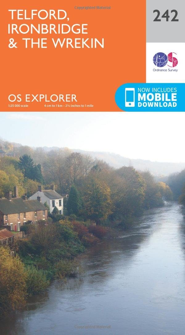
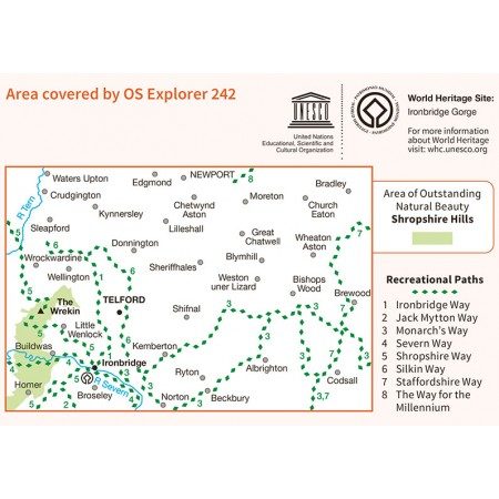
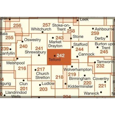
Wandelkaart 242 Telford- Ironbridge & the Wrekin - OSI
Omvat Ironbridge & The Wrekin & the Wrekin

Korte omschrijving
Wandelkaarten Shropshire West Midlands van Ordnance Survey. Ideaal voor tochten in England.
Wandelkaart Telford- Ironbridge & the Wrekin - Shropshire Productbeschrijving: OS Explorer kaart 242 heeft ruimschoots de gelegenheid voor verkennen en avontuur. Terwijl de regio meestal pla...

Specificaties
- Uitgever: Ordnance Survey
- ISBN-13: 9780319244357
- HOOFDCATEGORIEËN: Wandelkaart
- Activiteiten: Wandelen, Hiking & Trekking
- Regio: Shropshire West Midlands
- Land: England
- TOPO's & Stafkaarten: Topografisch wandelen
- Schaal: 1:25000
- Taal: Engels
- Reeks/Serie: Explorer Series OS
Volledige omschrijving
Wandelkaart Telford- Ironbridge & the Wrekin - Shropshire
Productbeschrijving: OS Explorer kaart 242 heeft ruimschoots de gelegenheid voor verkennen en avontuur. Terwijl de regio meestal plat is, kan de karakteristieke vorm van The Wrekin vanop enige afstand worden gezien en is een opvallende bezienswaardigheid onderweg door Shropshire. De OS Explorer kaart voor Ironbridge & The Wrekin, Telford is beschikbaar in zowel de standaard papieren versie als de weerbestendige 'Actief' versie.
Productdiscription: OS Explorer Map 242 has ample opportunity for exploring and adventure. While mostly flat, the distinctive shape of The Wrekin can be seen for some distance and is a distinctive landmark on the Shropshire Way. The OS Explorer map for Telford, Ironbridge & The Wrekin is available in both the standard paper version and weatherproof 'Active' version.
Locatie op kaart
Gekoppelde artikelen

Wandelkaart 242 Telford- Ironbridge & the Wrekin - OSI • 9780319244357
standaard versieWandelkaart Telford- Ironbridge & the Wrekin - Shropshire Productbeschrijving: OS Explorer kaart 242 heeft ruimschoots de gelegenheid voor verkennen en avontuur. Terwijl de regio meestal plat is, kan de karakteristieke vorm van The Wrekin vanop enige afstand worden gezien en is een opvallende bezienswaardigheid onderweg door Shropshire. De OS Explorer kaart voor Ironbridge & The Wrekin, Te…

Wandelkaart 242 Telford- Ironbridge & The Wrekin - OSI • 9780319471142
weatherproof versieWandelkaart Telford- Ironbridge & The Wrekin - Shropshire Productbeschrijving: OS Explorer kaart 242 bied ruimschoots de gelegenheid voor het verkennen en voor het avontuur. Terwijl de omgeving meestal plat is, en het als karakteristieke vorm van The Wrekin op afstand kan worden gezien, en is een opvallende bezienswaardigheid onderweg Shropshire. De OS Explorer kaart voor Ironbridge & The …
Overzichtskaarten

OSI Explorer & Explorer Active - Midden Engeland - Midlands
OSI Explorer & Explorer Active - Midden Engeland - Midlands

Producten op de overzichtskaart
Klik op een product om naar de detailpagina te gaan.
- Wandelkaart 180 Oxford- England - OSI
- Wandelkaart 181 Chiltern Hills North AONB- Wycombe - OSI
- Wandelkaart 182 St-Albans & Hatfield- Hertfordshire - OSI
- Wandelkaart 189 Hereford & Ross-on-Wye- England - OSI
- Wandelkaart 190 Malvern Hills AONB & Bredon Hill - OSI
- Wandelkaart 191 Banbury- Bicester & Chipping Norton- OSI
- Wandelkaart 192 Buckingham & Milton Keynes - OSI
- Wandelkaart 193 Luton & Stevenage- Bedfordshire - OSI
- Wandelkaart 194 Hertford & Bishop's Stortford - OSI
- Wandelkaart 202 Leominster & Bromyard Hererfordshire - OSI
- Wandelkaart 203 Ludlow & Shropshire Hills AONB - OSI
- Wandelkaart 204 Worcester & Droitwich Spa - OSI
- Wandelkaart 205 Stratford-upon-Avon & Evesham - OSI
- Wandelkaart 206 Edge Hill & Fenny Compton - OSI
- Wandelkaart 207 Newport Pagnell & Northampton - OSI
- Wandelkaart 208 Bedford & St Neots- Bedforeshire - OSI
- Wandelkaart 209 Cambridge - England - OSI
- Wandelkaart 217 Long Mynd & Wenlock Edge - OSI
- Wandelkaart 218 Kidderminster & Wyre Forest - OSI
- Wandelkaart 219 Wolverhampton & Dudley - OSI
- Wandelkaart 220 Birmingham- West Midlands - OSI
- Wandelkaart 221 Coventry & Warwickshire - OSI
- Wandelkaart 222 Rugby & Daventry- Warwickshire - OSI
- Wandelkaart 223 Northampton & Market Harborough - OSI
- Wandelkaart 224 Corby- Kettering & Wellingborough - OSI
- Wandelkaart 225 Huntingdon & St Ives - OSI
- Wandelkaart 227 Peterborough- Cambridgeshire England - OSI
- Wandelkaart 228 March- Ely- Chatteris & Littleport - OSI
- Wandelkaart 232 Nuneaton & Tamworth- Warwickshire - OSI
- Wandelkaart 233 Leicester & Hinckley England - OSI
- Wandelkaart 234 Rutland Water & Stamford- Oakham - OSI
- Wandelkaart 235 Wisbech & Peterborough North - OSI
- Wandelkaart 241 Shrewsbury- shropshire England - OSI
- Wandelkaart 242 Telford- Ironbridge & the Wrekin - OSI
- Wandelkaart 243 Market Drayton- Schropshire - OSI
- Wandelkaart 244 Cannock Chase & Chasewater- Severn - OSI
- Wandelkaart 245 National Forest- Burton-upon-Trent - OSI
- Wandelkaart 245 National Forest - OSI
- Wandelkaart 246 Loughborough- Leicestershire England - OSI
- Wandelkaart 247 Grantham- Lincolnshire - OSI
- Wandelkaart 248 Bourne & Heckington- lincolnshire - OSI
- Wandelkaart 249 Spalding & Holbeach- Lincolnshire - OSI
- Wandelkaart 257 Crewe & Nantwich & Cheshire East - OSI
- Wandelkaart 258 Stoke-on-Trent & Newcastle-under-Lyme- OSI
- Wandelkaart 259 Derby & Utoxeter- Derbyshire - OSI
- Wandelkaart 260 Nottingham & Vale of Belvoir - OSI
- Wandelkaart 261 Boston & Lincolnshire- England - OSI
- Wandelkaart 267 Northwich & Delamere Forest - OSI
- Wandelkaart 268 Wilmslow- Macclesfield & Congleton - OSI
- Wandelkaart 269 Chesterfield & Alfreton- Derbyshire- OSI
- Wandelkaart 270 Sherwood Forest- Nottinghamshire - OSI
- Wandelkaart 271 Newark-on-Trent- Nottinghampshire - OSI
- Wandelkaart 272 Lincoln- England - OSI
- Wandelkaart 273 Lincolnshire Wolds South- England - OSI
- Wandelkaart 274 Skegness- Alford & Spilsby - OSI
- Wandelkaart 275 Liverpool- South West England - OSI
- Wandelkaart 276 Bolton- Wigan & Warrington- Machester - OSI
- Wandelkaart 277 Manchester & Salford - OSI
- Wandelkaart 278 Sheffield & Barnsley- South Yorkshire - OSI
- Wandelkaart 279 Doncaster- South Yorkshire - OSI
- Wandelkaart 280 Isle of Axholme- Lincolnshire - OSI
- Wandelkaart 281 Ancholme Valley- Lincolnshire - OSI
- Wandelkaart 282 Lincolnshire Wolds North- England - OSI
- Wandelkaart 283 Louth & Mablethorpe- Lincolnshire - OSI
- Wandelkaart 284 Grimsby- Cleethorpes & Immingham - OSI
- Wandelkaart OL01 Peak District NP & Dark Peak area - OS
- Wandelkaart OL13 Brecon Beacons National Parc East - OS
- Wandelkaart OL24 Peak District & White Peak area - OS
- Wandelkaart OL40 The Broads National Park - OS
Artikelen uit dezelfde regio

Wandelkaart 203 Ludlow Tenbury Wells - OSI • 9780319470756
Wandelkaart Ludlow- Tenbury Wells & Cleobury Mortime Omvat ook: de Shropshire Hills AONB Productbeschrijving: Na de rivier Teme, en met het zuiden van de Shropshire Hills Area of Outstanding Natural Beauty AONB, kunt u onder meer de Hertfordshire Trail en Shropshire Way, verkennen. Ook vindt u de middeleeuwse ommuurde stad van Ludlow en Ludlow kasteel uit de 11e eeuw. De OS Explorer ka…

Wandelkaart 240 Oswestry & Croesoswallt- Shropshir - OSI • 9780319244333
Wandelkaart Oswestry & Croesoswallt - Shropshire England Omvat ook: Chirk, Ellesmere & Pant. Productomschrijving: Explorer map 240 is gericht op Oswestry (Croesoswallt) en heeft een deel van de "Severn Way" en de "Offa's Dyke Path" (Llwybr Clawdd Offa) die de grens van Engeland & Wales volgen. Er zijn een aantal kleinere steden en dorpen in het gebied, waaronder Chirk (Y Waun), broek, …

Wandelgids 080 Pathfinder guides Shropshire England - OS • 9780319092040
Wandelgids Shropshire England - OS Productomschrijving: 180 miles of stunning walking among A. E. Housman's 'Blue remembered hills' of the Shropshire Hills Ara of Outstanding Natural Beauty, including the Long Mynd, Stiperstones, and Caer Caradoc. There's also a climb to the top of The Wrekin. By way of contrast, walks visit the marshy meres of Brown and Whixall Moss, the World Heritage S…

Wandelkaart 240 Oswestry & Croesoswallt- England - OSI • 9780319471128
Wandelkaart Oswestry & Croesoswallt -- Shropshire England Omvat ook: Chirk, Ellesmere & Pant. Productbeschrijving: Explorer map 240 is gericht op Oswestry (Croesoswallt) en heeft een deel van de "Severn Way" en de "Offa's Dyke Path" (Llwybr Clawdd Offa) die de grens van Engeland & Wales volgen. Er zijn een aantal kleinere steden en dorpen in het gebied, waaronder Chirk (Y Waun), broek,…

Wandelgids The Offa's Dyke Path - England & Wales - Cicerone • 9781852847760
Wandelgids The Offa's Dyke Path - Wales - Cicerone Productomschrijving: Deze gids beschrijft het Offa's Dyke Path National Trail, een langeafstandswandeling van 283 km langs de Engels-Welshe grens tussen Sedbury (bij Chepstow) en Prestatyn. De gids is opgedeeld in 12 etappes met suggesties voor het plannen van alternatieve routes. Met 1:25K OSI (Ordnance Servey) kaart boekje. Engelse o…