

Wandelgids 080 Pathfinder guides Shropshire England - OS
A. E. Housman's 'Blue remembered hills - Shropshire Hills AONB


Korte omschrijving
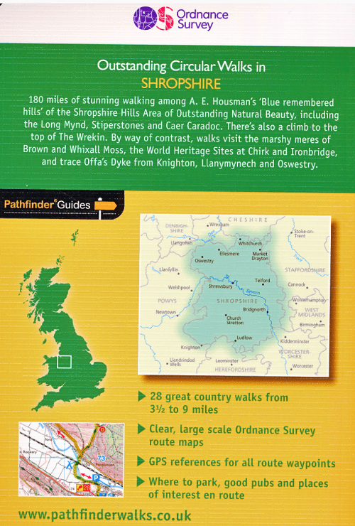
Wandelgids Shropshire England - OS Productomschrijving: 180 miles of stunning walking among A. E. Housman's 'Blue remembered hills' of the Shropshire Hills Ara of Outstanding Natural Beauty...

Specificaties
- Uitgever: Ordnance Survey
- ISBN-13: 9780319092040
- HOOFDCATEGORIEËN: Wandelgids
- Activiteiten: Wandelen, Hiking & Trekking
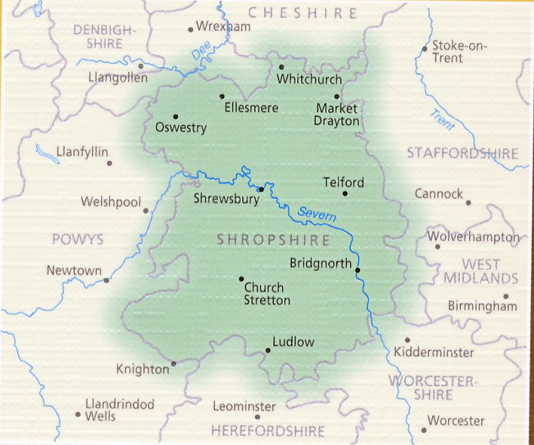
- Regio: Shropshire West Midlands
- Land: England
- AONB - Area of Outstanding Beauty: Shropshire Hills AONB
- Taal: Engels
- Reeks/Serie:: Outstanding Circular Walks, Pathfinder Series, OS
Volledige omschrijving
Wandelgids Shropshire England - OS
Productomschrijving: 180 miles of stunning walking among A. E. Housman's 'Blue remembered hills' of the Shropshire Hills Ara of Outstanding Natural Beauty, including the Long Mynd, Stiperstones, and Caer Caradoc. There's also a climb to the top of The Wrekin. By way of contrast, walks visit the marshy meres of Brown and Whixall Moss, the World Heritage Sites at Chirk and Ironbridge, and Trace Offa's Dyke from Knighton, Llanymyech and Oswestry.
Overzichtskaarten

Overzicht Pathfinder guides - OS
Overzicht Pathfinder guides - OS

Producten op de overzichtskaart
Klik op een product om naar de detailpagina te gaan.
- Wandelgids 001 Pathfinder guides South Devon & Dartmoor NP - OS
- Wandelgids 003 Pathfinder guides Isle of Skye - OS
- Wandelgids 004 Pathfinder guides Cairngorms NP - OS
- Wandelgids 005 Pathfinder guides Cornwall England - OS
- Wandelgids 006 Pathfinder guides Cotswolds AONB - OS
- Wandelgids 007 Pathfinder guides Fort William & Glen Coe - OS
- Wandelgids 008 Pathfinder guides Kent - OS
- Wandelgids 009 Pathfinder guides Exmoor NP & the Quantocks - OS
- Wandelgids 010 Pathfinder guides Snowdonia NP Wales - OS
- Wandelgids 011 Pathfinder guides Dorset England - OS
- Wandelgids 012 Pathfinder New Forest & South Downs NP Hampshire
- Wandelgids 015 Pathfinder guides Yorkshire Dales NP - OS
- Wandelgids 018 Pathfinder guides Brecon Beacons Wales - OS
- Wandelgids 019 Pathfinder guides Dumfries & Galloway - OS
- Wandelgids 020 Pathfinder guides Sherwood Forest - OS
- Wandelgids 022 Pathfinder guides More Lake District - OS
- Wandelgids 023 Pathfinder guides Loch Lomond, Trossachs NP - OS
- Wandelgids 025 Pathfinder guides Thames Valley & Chilterns - OS
- Wandelgids 026 Pathfinder guides Dartmoor National Park - OS
- Wandelgids 027 Pathfinder Perthshire "big county" Angus & Five OS
- Wandelgids 028 Pathfinder guides North York Moors NP - OS
- Wandelgids 029 Pathfinder guides Wye Valley AONB & Forrest of Dean
- Wandelgids 030 Pathfinder guides Loch Ness & Iverness - OS
- Wandelgids 031 Pathfinder guides Oban, Mull & Kintyre - OS
- Wandelgids 034 Pathfinder guides Pembrokeshire Wales - OS
- Wandelgids 035 Pathfinder guides Northumberland- Scottish Borders
- Wandelgids 039 Pathfinder Durham, North Pennines & Tyne & Wear OS
- Wandelgids 041 Pathfinder guides Central Wales - OS
- Wandelgids 042 Pathfinder guides Cheshire England - OS
- Wandelgids 044 Pathfinder guides Essex England - OS
- Wandelgids 045 Pathfinder guides Norfolk - OS
- Wandelgids 046 Pathfinder guides Aberdeen & Royal Deeside - OS
- Wandelgids 047 Pathfinder Edinburgh, Pentlands & Lothians - OS
- Wandelgids 048 Pathfinder guides Suffolk East England - OS
- Wandelgids 049 Pathfinder guides Vale of York East England - OS
- Wandelgids 050 Pathfinder guides Lincolnshire & the Wolds - OS
- Wandelgids 051 Pathfinder guides Cambridgeshire & The Fens - OS
- Wandelgids 053 Pathfinder guides Lancashire NW En England - OS
- Wandelgids 054 Pathfinder guides Hertfordshire & Bedfordshire- OS
- Wandelgids 055 Pathfinder guides Gower, Swansea & Cardiff - OS
- Wandelgids 060 Pathfinder guides Lake District NP - OS
- Wandelgids 063 Pathfinder guides Peak District England - OS
- Wandelgids 064 Pathfinder guides South Pennines - OS
- Wandelgids 065 Pathfinder guides Surrey England - OS
- Wandelgids 066 Pathfinder guides West Sussex & South Downs - OS
- Wandelgids 067 Pathfinder guides South Downs NP & East Sussex- OS
- Wandelgids 068 Pathfinder guides Devon North & Mid - OS
- Wandelgids 069 Pathfinder guides South West England Coastal walks
- Wandelgids 071 Pathfinder guides High Fells of Lakeland - OS
- Wandelgids 073 Pathfinder guides More Peak District - OS
- Wandelgids 074 Pathfinder guides Malverns to Warwickshire - OS
- Wandelgids 076 Pathfinder guides Somerset & the Mendips Hills- OS
- Wandelgids 077 Pathfinder guides Wiltshire - OS
- Wandelgids 078 Pathfinder guide Anglesey, Lleyn & Snowdonia - OS
- Wandelgids 079 Pathfinder guides Dee Valley & Clwydian hills - OS
- Wandelgids 080 Pathfinder guides Shropshire England - OS
- Wandelgids 081 Pathfinder guides Staffordshire - OS
- Wandelgids 082 Pathfinder guides Orkney & Shetland Islands - OS
- Wandelgids 083 Pathfinder North Coast 500 & Northern Highlands
- Wandelgids 084 Pathfinder Berkshire- Buckinghamshire- Oxfordshire
- Wandelgids 085 Pathfinder guides Outer hebrides Schotland - OS
- Wandelgids 086 Pathfinder guides Lake District and Cumbria - OS
- Wandelgids 087 Pathfinder guides Northumberland - OS
- Wandelgids 088 Pathfinder guides Scottish Borders - OS
- Wandelgids 093 Pathfinde North Yorkshire Accessible walks - OS
- Wandelgids 094 Pathfinder guides The Isle of Wight - OS
Artikelen uit dezelfde regio

Wandelkaart 217 Long Mynd & Wenlock Edge- Schropshire- OSI • 9780319475492
Wandelkaart Long Mynd & Wenlock Edge - Schropshire England Engelse omschrijving: The Long Mynd is a heath and moorland plateau that forms part of the Shropshire Hills in Shropshire AONB, England. The high ground, which is designated as an Area of Outstanding Natural Beauty, lies between the Stiperstones range to the west and the Stretton Hills and Wenlock Edge to the east. Much of it is ow…

Wandelkaart 137 Ludlow & Church Stretton - England - OSI • 9780319474600
Wandelkaart Ludlow - Church Stretton & Wenlock Edge Shropshire Productbeschrijving: Kaart nummer 137 in de reeks van de OS Landranger kaarten, Omvat een AONB, een Area of Outstanding Natural Beauty, en de steden Church Stretton en Ludlow hebben veel te bieden als gevolg daarvan. Hoogtepunten van de regio zijn ongerepte natuur, heuvel forten, kastelen, boerenmarkten en uitstekend wandelen e…

Wandelkaart 126 Shrewsbury & Oswestry England - OSI • 9780319474495
Wandelkaart Shrewsbury & Oswestry - Shropshire England Productbeschrijving: Kaart nummer 126 in de OS Landranger kaarten reeks, dekt Shrewsbury en het omliggende gebied. Hoogtepunten van Shrewsbury zijn Shrewsbury Castle, St. Mary's kerk en de oude ruïnes van de abdij. Oswestry ligt dicht bij het Wales grensgebied, een charmant stadje Shropshire met vele attracties zoals Chirk castle. …

Wandelkaart 241 Shrewsbury- shropshire England - OSI • 9780319244340
Wandelkaart Shrewsbury - shropshire England Omvat ook: Wem, Shawbury & Baschurch. Productbeschrijving: De Shropshire en Severn Way kruis in Shrewsbury. Neem de tijd om met deze OS Explorer kaart 241 de middeleeuwse stad en de historische gebouwen te ontdekken. Buiten de stad zijn er kleine bossen en heidevelden om te verkennen. De OS Explorer kaart voor Shrewsbury is beschikbaar in zow…
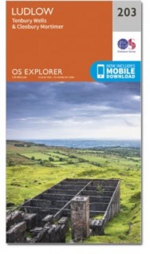
Wandelkaart 203 Ludlow & Shropshire Hills AONB - OSI • 9780319243961
Wandelkaart Ludlow - Shropshire Hills AONB England Omvat ook: Tenbury Wells & Cleobury Mortimer. Productbeschrijving: Naast de rivier Teme, en met het zuiden van de Shropshire Hills Area of Outstanding Natural Beauty AONB, kunt u onder andere de Hertfordshire Trail en Shropshire Way verkennen. Ook vindt u de middeleeuwse ommuurde stad van Ludlow en Ludlow kasteel uit de 11e eeuw. De OS…