

Wandelgids 029 Pathfinder guides Wye Valley AONB & Forrest of Dean
Herefordshire - Hay-on-Wye - Hereford - Chepstow - Symonds Yat


Korte omschrijving
Wandelgidsen Gloucestershire, Egland van Ordnance Survey. Ideaal voor tochten in England.
Wandelgids Wye Valley AONB & Forrest of Dean -OS Productomschrijving: The Wye Valley and Forest of Dean Pathfinder guidebook contains 28 circular walks for all abilities. Walks are from 4km...

Specificaties
- Uitgever: Ordnance Survey
- ISBN-13: 9780319090442
- HOOFDCATEGORIEËN: Wandelgids
- Activiteiten: Wandelen, Hiking & Trekking
- Regio: Gloucestershire, Egland
- Land: England
- Regionale parken: Forest of Dean, England
- AONB - Area of Outstanding Beauty/National Landscape: Wye Valley, AONB
- Taal: Engels
- Reeks/Serie: Outstanding Circular Walks, Pathfinder Series, OS
- De Engelse Graafschappen: Gloucestershire
Volledige omschrijving
Wandelgids Wye Valley AONB & Forrest of Dean -OS
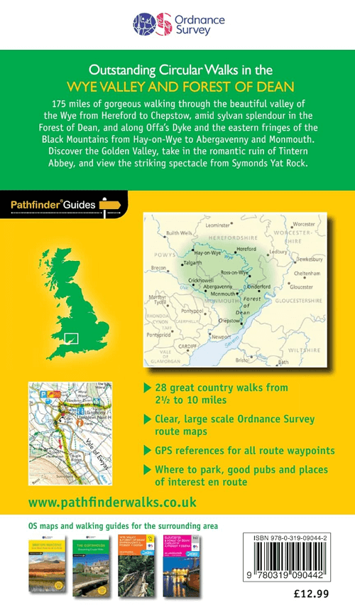
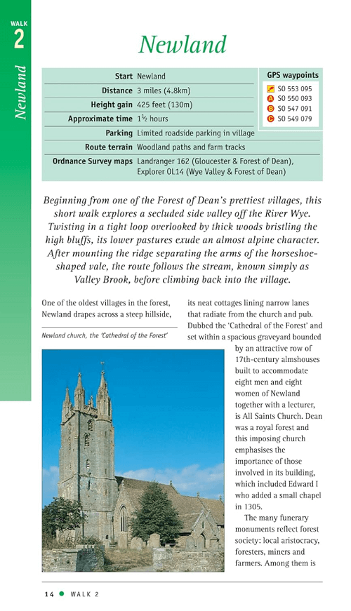
Productomschrijving: The Wye Valley and Forest of Dean Pathfinder guidebook contains 28 circular walks for all abilities. Walks are from 4km to 17km long, and each route includes a difficulty rating, route directions, an extract of the Ordnance Survey map and notes and photos of key features to look for. All of them have been created and tested by experienced walkers to help you make the most of the area.
This guide focuses on the middle and lower sections of the Wye Valley, roughly where the river leaves its upper reaches in mid-Wales to enter Herefordshire. Hay-on-Wye, Hereford and the walled town of Chepstow are also covered, as is the classic view over the winding Wye Valley from Symonds Yat. The imposing ruins of medieval castles can often be found, a striking reminder of ancient warfare in the area.
This is part of the Pathfinder series of guidebooks, which have carefully selected walks in the most popular areas of Britain..

Overzichtskaarten

Overzicht Pathfinder guides - OS
Overzicht Pathfinder guides - OS

Producten op de overzichtskaart
Klik op een product om naar de detailpagina te gaan.
- Wandelgids 001 Pathfinder guides South Devon & Dartmoor NP - OS
- Wandelgids 003 Pathfinder guides Isle of Skye - OS
- Wandelgids 004 Pathfinder guides Cairngorms NP - OS
- Wandelgids 005 Pathfinder guides Cornwall England - OS
- Wandelgids 006 Pathfinder guides Cotswolds AONB - OS
- Wandelgids 007 Pathfinder guides Fort William & Glen Coe - OS
- Wandelgids 008 Pathfinder guides Kent - OS
- Wandelgids 009 Pathfinder guides Exmoor NP & the Quantocks - OS
- Wandelgids 010 Pathfinder guides Snowdonia NP Wales - OS
- Wandelgids 011 Pathfinder guides Dorset England - OS
- Wandelgids 012 Pathfinder New Forest & South Downs NP Hampshire
- Wandelgids 015 Pathfinder guides Yorkshire Dales NP - OS
- Wandelgids 018 Pathfinder guides Brecon Beacons Wales - OS
- Wandelgids 019 Pathfinder guides Dumfries & Galloway - OS
- Wandelgids 020 Pathfinder guides Sherwood Forest - OS
- Wandelgids 022 Pathfinder guides More Lake District - OS
- Wandelgids 023 Pathfinder guides Loch Lomond, Trossachs NP - OS
- Wandelgids 025 Pathfinder guides Thames Valley & Chilterns - OS
- Wandelgids 026 Pathfinder guides Dartmoor National Park - OS
- Wandelgids 027 Pathfinder Perthshire "big county" Angus & Five OS
- Wandelgids 028 Pathfinder guides North York Moors NP - OS
- Wandelgids 029 Pathfinder guides Wye Valley AONB & Forrest of Dean
- Wandelgids 030 Pathfinder guides Loch Ness & Iverness - OS
- Wandelgids 031 Pathfinder guides Oban, Mull & Kintyre - OS
- Wandelgids 034 Pathfinder guides Pembrokeshire Wales - OS
- Wandelgids 035 Pathfinder guides Northumberland- Scottish Borders
- Wandelgids 039 Pathfinder Durham, North Pennines & Tyne & Wear OS
- Wandelgids 041 Pathfinder guides Central Wales - OS
- Wandelgids 042 Pathfinder guides Cheshire England - OS
- Wandelgids 044 Pathfinder guides Essex England - OS
- Wandelgids 045 Pathfinder guides Norfolk - OS
- Wandelgids 046 Pathfinder guides Aberdeen & Royal Deeside - OS
- Wandelgids 047 Pathfinder Edinburgh, Pentlands & Lothians - OS
- Wandelgids 048 Pathfinder guides Suffolk East England - OS
- Wandelgids 049 Pathfinder guides Vale of York East England - OS
- Wandelgids 050 Pathfinder guides Lincolnshire & the Wolds - OS
- Wandelgids 051 Pathfinder guides Cambridgeshire & The Fens - OS
- Wandelgids 053 Pathfinder guides Lancashire NW En England - OS
- Wandelgids 054 Pathfinder guides Hertfordshire & Bedfordshire- OS
- Wandelgids 055 Pathfinder guides Gower, Swansea & Cardiff - OS
- Wandelgids 060 Pathfinder guides Lake District NP - OS
- Wandelgids 063 Pathfinder guides Peak District England - OS
- Wandelgids 064 Pathfinder guides South Pennines - OS
- Wandelgids 065 Pathfinder guides Surrey England - OS
- Wandelgids 066 Pathfinder guides West Sussex & South Downs - OS
- Wandelgids 067 Pathfinder guides South Downs NP & East Sussex- OS
- Wandelgids 068 Pathfinder guides Devon North & Mid - OS
- Wandelgids 069 Pathfinder guides South West England Coastal walks
- Wandelgids 071 Pathfinder guides High Fells of Lakeland - OS
- Wandelgids 073 Pathfinder guides More Peak District - OS
Artikelen uit dezelfde regio
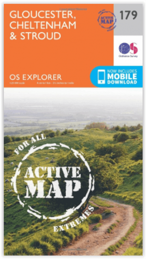
Wandelkaart 179 Gloucester- Cheltenham & Stroud - OSI • 9780319470510
Wandelkaart Gloucester- Cheltenham & Stroud - S.W. England Productbeschrijving: Kaart nummer 179 in de OS Explorer reeks heeft betrekking op de omgeving van Gloucester, Cheltenham, Stroud. Hoogtepunten van het gebied zijn onder andere: Cotswolds AONB gebied van uitzonderlijke natuurlijke schoonheid AONB, Vale van Gloucester, rivier de Severn en de Cotswolds way. De OS Explorer kaart voor G…

Fotoboek Cotswold - The landscape of Britain - Goldeneye • 9781859652312
Fotoboek Cotswold Collection - The landscape of Britain Productomschrijving: Dit prachtig geproduceerde boek van fotografie vangt de essentie van de Cotswolds op, van de huiselijke dorpen, de kerken en de landhuizen, naar de betoverende wildernis van de zachte riviervalleien en glooiende heuvels - een vertrouwd landschap gevangen op een unieke en opvallende manier. De foto's werden sa…
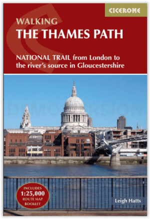
Wandelgids Walking the Thames Path National Trail - Cicerone • 9781786311481
Thames Path National Trail - Cicerone Productomschrijving: Een gloednieuwe wandelgids vover het Theemspad, een National Trail van 180 mijl tussen de Thames Barrier in Londen en de bron van de rivier in Gloucestershire, door Windsor, Oxford en het platteland. Biedt volledige informatie over deze gemakkelijke route langs de rivier die ongeveer twee weken in beslag neemt. Inclusief een 1:25K …

Wandelkaart 163 Cheltenham & Cirencester- England - OSI • 9780319474860
Wandelkaart Cheltenham & Cirencester - Gloucestershire England Productbeschrijving: De way of the Cotswold, Thames path en de Europese lange afstand pad, doorsnijden allemaal de op de OS Landranger vallende regio E2 kaart 163, waardoor het een fantastische locatie is om te wandelen en het landschap op te nemen. Cheltenham, het Cultuurcentrum vernoemd naar de Cotswolds, is een historische s…

Wandelgids 006 Pathfinder guides Cotswolds AONB - OS • 9780319090282
Wandelgids Cotswolds AONB - OS Productomschrijving: 28 carefully selected and tested country walks around The Cotswolds, graded by length and ranging from just over four to 10 miles. All of the walks in this book include written directions, an extract of the OS map for the area and some background on the history and natural environment you may see. Most of the walks avoid busy roads, a…