

Wandelgids 012 Pathfinder New Forest & South Downs NP Hampshire
Itchen and Test valley - Bishop's Dyke - Kingsclere - Watership


Korte omschrijving
Wandelgidsen Hampshire, England en Southampton, England van Ordnance Survey. Ideaal voor tochten in England.
Wandelgids New Forest & South Downs NP Hampshire - OS Productomschrijving: This Pathfinder walking guidebook covers the New Forest National Park, Hampshire and the South Downs National Park...

Specificaties
- Uitgever: Ordnance Survey
- ISBN-13: 9780319090107
- HOOFDCATEGORIEËN: Wandelgids
- Activiteiten: Wandelen, Hiking & Trekking
- Auteur: David Foster
- Regio: Hampshire, England, Southampton, England
- Land: England
- Nationale parken: New Forest National Park, England, South Downs NP, Sussex Egland
- Taal: Engels
- Reeks/Serie: Outstanding Circular Walks, Pathfinder Series, OS
- De Nationale Parken: South Downs National Park, England
- De Engelse Graafschappen: East Sussex, Hampshire
Volledige omschrijving
Wandelgids New Forest & South Downs NP Hampshire - OS
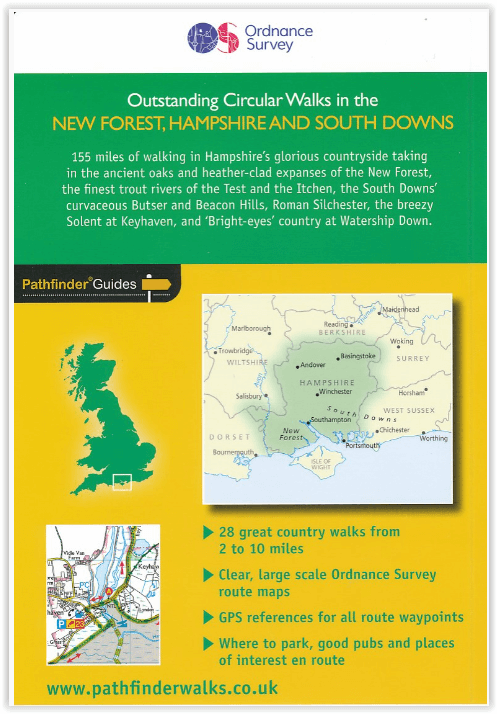
Productomschrijving: This Pathfinder walking guidebook covers the New Forest National Park, Hampshire and the South Downs National Park, including the Itchen and Test valleys. There are 28 outstanding circular walks in the Hampshire countryside ranging from two to ten miles in length, and graded by difficulty by expert outdoor writer David Foster.
Each route has clear, easy-to-follow route descriptions, an Ordnance Survey route map, GPS waypoints, parking information and places of interest on the route. You can choose from an stroll across typical New Forest heathland at Bishop's Dyke to the much more energetic downland walking around Kingsclere and Watership Down or exploring the beautiful Meon Valley.
Pathfinder Guides are Britain’s best-loved walking guides. Printed with weather-resistant covers featuring durable rounded corners, they are the perfect companion for country walking throughout Britain.
Overzichtskaarten

Overzicht Pathfinder guides - OS
Overzicht Pathfinder guides - OS

Producten op de overzichtskaart
Klik op een product om naar de detailpagina te gaan.
- Wandelgids 001 Pathfinder guides South Devon & Dartmoor NP - OS
- Wandelgids 003 Pathfinder guides Isle of Skye - OS
- Wandelgids 004 Pathfinder guides Cairngorms NP - OS
- Wandelgids 005 Pathfinder guides Cornwall England - OS
- Wandelgids 006 Pathfinder guides Cotswolds AONB - OS
- Wandelgids 007 Pathfinder guides Fort William & Glen Coe - OS
- Wandelgids 008 Pathfinder guides Kent - OS
- Wandelgids 009 Pathfinder guides Exmoor NP & the Quantocks - OS
- Wandelgids 010 Pathfinder guides Snowdonia NP Wales - OS
- Wandelgids 011 Pathfinder guides Dorset England - OS
- Wandelgids 012 Pathfinder New Forest & South Downs NP Hampshire
- Wandelgids 015 Pathfinder guides Yorkshire Dales NP - OS
- Wandelgids 018 Pathfinder guides Brecon Beacons Wales - OS
- Wandelgids 019 Pathfinder guides Dumfries & Galloway - OS
- Wandelgids 020 Pathfinder guides Sherwood Forest - OS
- Wandelgids 022 Pathfinder guides More Lake District - OS
- Wandelgids 023 Pathfinder guides Loch Lomond, Trossachs NP - OS
- Wandelgids 025 Pathfinder guides Thames Valley & Chilterns - OS
- Wandelgids 026 Pathfinder guides Dartmoor National Park - OS
- Wandelgids 027 Pathfinder Perthshire "big county" Angus & Five OS
- Wandelgids 028 Pathfinder guides North York Moors NP - OS
- Wandelgids 029 Pathfinder guides Wye Valley AONB & Forrest of Dean
- Wandelgids 030 Pathfinder guides Loch Ness & Iverness - OS
- Wandelgids 031 Pathfinder guides Oban, Mull & Kintyre - OS
- Wandelgids 034 Pathfinder guides Pembrokeshire Wales - OS
- Wandelgids 035 Pathfinder guides Northumberland- Scottish Borders
- Wandelgids 039 Pathfinder Durham, North Pennines & Tyne & Wear OS
- Wandelgids 041 Pathfinder guides Central Wales - OS
- Wandelgids 042 Pathfinder guides Cheshire England - OS
- Wandelgids 044 Pathfinder guides Essex England - OS
- Wandelgids 045 Pathfinder guides Norfolk - OS
- Wandelgids 046 Pathfinder guides Aberdeen & Royal Deeside - OS
- Wandelgids 047 Pathfinder Edinburgh, Pentlands & Lothians - OS
- Wandelgids 048 Pathfinder guides Suffolk East England - OS
- Wandelgids 049 Pathfinder guides Vale of York East England - OS
- Wandelgids 050 Pathfinder guides Lincolnshire & the Wolds - OS
- Wandelgids 051 Pathfinder guides Cambridgeshire & The Fens - OS
- Wandelgids 053 Pathfinder guides Lancashire NW En England - OS
- Wandelgids 054 Pathfinder guides Hertfordshire & Bedfordshire- OS
- Wandelgids 055 Pathfinder guides Gower, Swansea & Cardiff - OS
- Wandelgids 060 Pathfinder guides Lake District NP - OS
- Wandelgids 063 Pathfinder guides Peak District England - OS
- Wandelgids 064 Pathfinder guides South Pennines - OS
- Wandelgids 065 Pathfinder guides Surrey England - OS
- Wandelgids 066 Pathfinder guides West Sussex & South Downs - OS
- Wandelgids 067 Pathfinder guides South Downs NP & East Sussex- OS
- Wandelgids 068 Pathfinder guides Devon North & Mid - OS
- Wandelgids 069 Pathfinder guides South West England Coastal walks
- Wandelgids 071 Pathfinder guides High Fells of Lakeland - OS
- Wandelgids 073 Pathfinder guides More Peak District - OS
Artikelen uit dezelfde regio
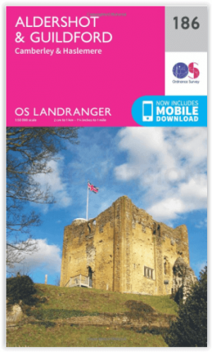
Wandelkaart 186 Aldershot & Guildford - England - OSI • 9780319262849
Wandelkaart Aldershot & Guildford - Hampshire England Productbeschrijving: Kaart nummer 186 in de OS Landranger kaarten reeks, is perfect voor het plannen van een vakantie in het gebied Aldershot en Guildford. Deze plaats heeft vele bezienswaardigheden en bezeigheden, zoals de fantastische winkels in Guildford, of wandelen in de Noord-Downs. Hoogtepunten van het gebied: The North Downs Way…

Fietsgids Cycling Days Out - South East England - Vertebrate Publ • 9781906148249
Cycling Days Out - South East England - Vertebrate Productomschrijving: Traffic-free family and leisure cycling in Kent, Sussex, Surrey & Hampshire. Cycling Days Out – South East England is a guide to traffic-free family and leisure cycling in Kent, Sussex, Surrey and Hampshire. Written by local author Deirdre Huston, it explores tourist trails, country parks, forest riding and more. …

Wandelkaart 131 Romsey & Andover - Hampshire - OSI • 9780319243275
Wandelkaart Romsey- Andover & Test Valley - Hampshire England Omvat ook: Stockbridge & Ludgershall. Productbeschrijving: Kaart nummer 131 in de OS Explorer reeks heeft betrekking op het gebied van Oxenwood en Ashmansworth in het noorden tot Romsey en Redlynch in het zuiden. Hoogtepunten van het gebied zijn onder andere: Andover, Ludgershall, Stockbridge en de wandelingen van de Test Wa…

Wandelkaart 186 Aldershot & Guildford - England - OSI • 9780319475096
Wandelkaart Aldershot & Guildford- Camberley - Hampshire Productbeschrijving: Kaart nummer 186 OS Landranger kaarten reeks, is perfect voor het plannen van daguitstapjes in het gebied rond Aldershot en Guildford. Hier valt veel te doen en te zien, zoals de fantastische winkels in Guildford of wandelingen in de Noord-Downs. Hoogtepunten van het gebied: The North Downs Way, Guildford, Alton …
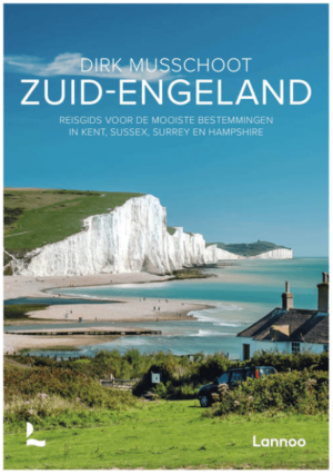
Reisgids Zuid-Engeland - Uitgeverij Lannoo • 9789059960978
Reisgids Zuid-Engeland - Lannoo Productomschrijving: Engelandkenner Dirk Musschoot laat je op een onovertroffen wijze kennismaken met de regio's Kent, East en West Sussex, Surrey, Hampshire en het eiland Wight, en de bestemmingen die je daar absoluut niet mag missen. Enkele voorbeelden: de optrekjes van Charles Darwin, Winston Churchill en Rudyard Kipling, de imposante kliffen van Beac…