

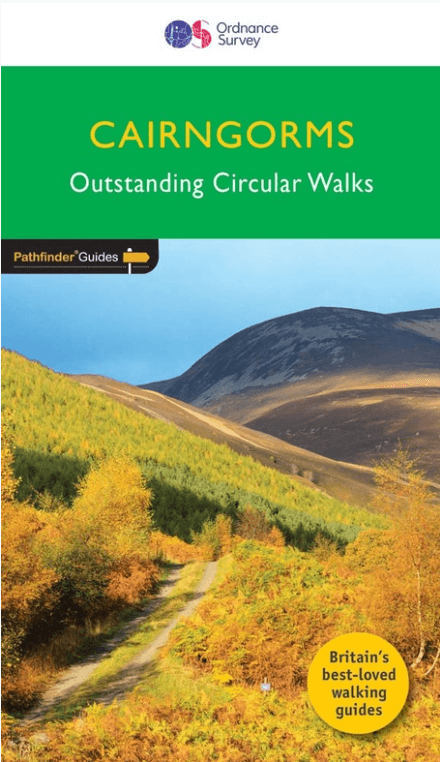
Wandelgids 004 Pathfinder guides Cairngorms NP - OS
Loch Garten - RSPB osprey - Summit of Carn Daimh - Speyside Way
Korte omschrijving
Wandelgidsen Eastern Highlands, Schotland en Highlands, Schotland van Ordnance Survey. Ideaal voor tochten in Schotland.
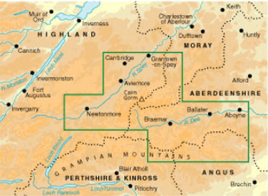
Wandelgids Cairngorms National Park - OS Productomschrijving: The Cairngorms NP covers 300 sq miles, making it the most mountainous area in Britain, with an equally wide range of wildlife. ...

Specificaties
- Uitgever: Ordnance Survey
- ISBN-13: 9780319090398
- HOOFDCATEGORIEËN: Wandelgids
- Activiteiten: Wandelen, Hiking & Trekking
- Regio: Eastern Highlands, Schotland, Highlands, Schotland
- Land: Schotland
- Toepasselijke bergketen: Schotse Highlands, Schotland
- Nationale parken: Cairngorms NP, Schotland
- Taal: Engels
- Reeks/Serie: Outstanding Circular Walks, Pathfinder Series, OS
- Iconische Bergketens van Europa: De Schotse Highlands
Volledige omschrijving
Wandelgids Cairngorms National Park - OS
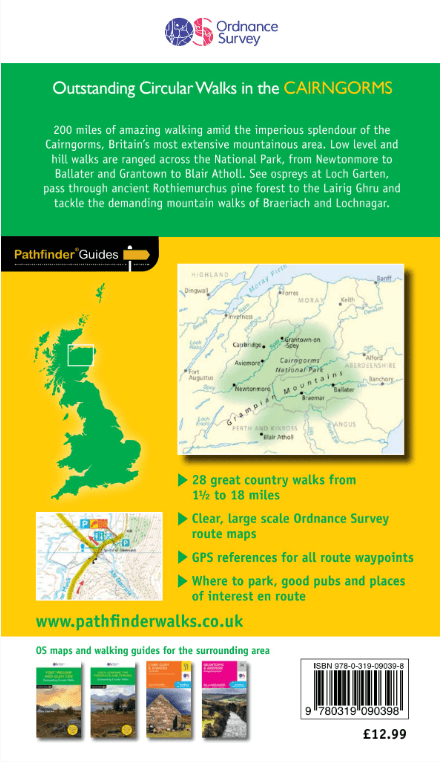
Productomschrijving: The Cairngorms NP covers 300 sq miles, making it the most mountainous area in Britain, with an equally wide range of wildlife. This walking guidebook contains 28 carefully selected walking routes of 1.5 to 18 miles, each tested and graded by experienced walkers.
All routes include information on getting to the start point, a detailed route description, large-scale OS mapping and notes on key features and wildlife to look for. The native pine forest of the Cairngorms is one of the final retreats of the red squirrel and supports small, uncommon birds like crested tits, redwings and crossbills.
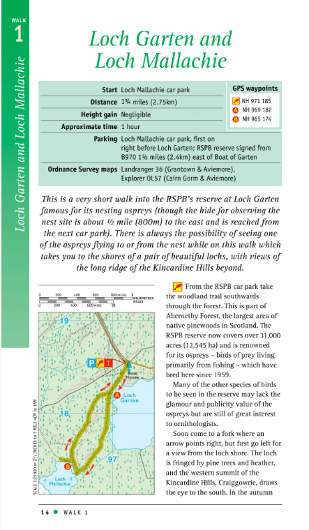
Key places to visit include Loch Garten, the RSPB osprey breeding site, an ascent to the summit of Carn Daimh, part of the Speyside Way, with its splendid panorama of the countryside surrounding Glenlivet and the Falls of the Glas Allt.
Overzichtskaarten

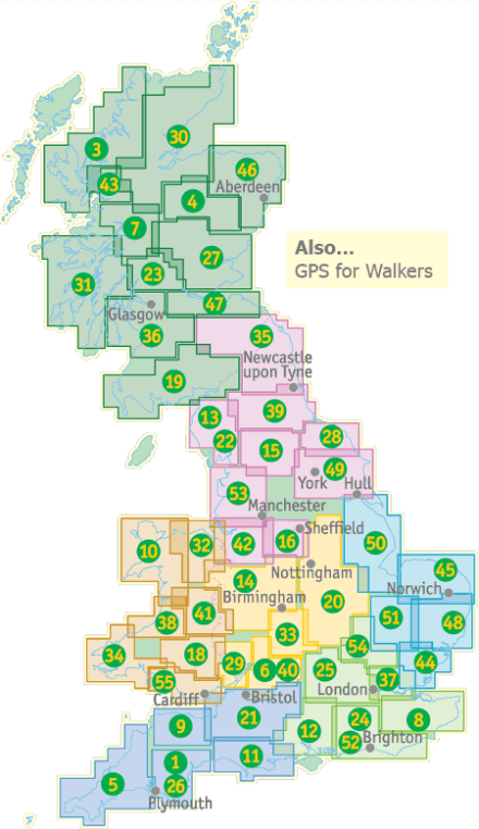
Overzicht Pathfinder guides - OS
Overzicht Pathfinder guides - OS

Producten op de overzichtskaart
Klik op een product om naar de detailpagina te gaan.
- Wandelgids 001 Pathfinder guides South Devon & Dartmoor NP - OS
- Wandelgids 003 Pathfinder guides Isle of Skye - OS
- Wandelgids 004 Pathfinder guides Cairngorms NP - OS
- Wandelgids 005 Pathfinder guides Cornwall England - OS
- Wandelgids 006 Pathfinder guides Cotswolds AONB - OS
- Wandelgids 007 Pathfinder guides Fort William & Glen Coe - OS
- Wandelgids 008 Pathfinder guides Kent - OS
- Wandelgids 009 Pathfinder guides Exmoor NP & the Quantocks - OS
- Wandelgids 010 Pathfinder guides Snowdonia NP Wales - OS
- Wandelgids 011 Pathfinder guides Dorset England - OS
- Wandelgids 012 Pathfinder New Forest & South Downs NP Hampshire
- Wandelgids 015 Pathfinder guides Yorkshire Dales NP - OS
- Wandelgids 018 Pathfinder guides Brecon Beacons Wales - OS
- Wandelgids 019 Pathfinder guides Dumfries & Galloway - OS
- Wandelgids 020 Pathfinder guides Sherwood Forest - OS
- Wandelgids 022 Pathfinder guides More Lake District - OS
- Wandelgids 023 Pathfinder guides Loch Lomond, Trossachs NP - OS
- Wandelgids 025 Pathfinder guides Thames Valley & Chilterns - OS
- Wandelgids 026 Pathfinder guides Dartmoor National Park - OS
- Wandelgids 027 Pathfinder Perthshire "big county" Angus & Five OS
- Wandelgids 028 Pathfinder guides North York Moors NP - OS
- Wandelgids 029 Pathfinder guides Wye Valley AONB & Forrest of Dean
- Wandelgids 030 Pathfinder guides Loch Ness & Iverness - OS
- Wandelgids 031 Pathfinder guides Oban, Mull & Kintyre - OS
- Wandelgids 034 Pathfinder guides Pembrokeshire Wales - OS
- Wandelgids 035 Pathfinder guides Northumberland- Scottish Borders
- Wandelgids 039 Pathfinder Durham, North Pennines & Tyne & Wear OS
- Wandelgids 041 Pathfinder guides Central Wales - OS
- Wandelgids 042 Pathfinder guides Cheshire England - OS
- Wandelgids 044 Pathfinder guides Essex England - OS
- Wandelgids 045 Pathfinder guides Norfolk - OS
- Wandelgids 046 Pathfinder guides Aberdeen & Royal Deeside - OS
- Wandelgids 047 Pathfinder Edinburgh, Pentlands & Lothians - OS
- Wandelgids 048 Pathfinder guides Suffolk East England - OS
- Wandelgids 049 Pathfinder guides Vale of York East England - OS
- Wandelgids 050 Pathfinder guides Lincolnshire & the Wolds - OS
- Wandelgids 051 Pathfinder guides Cambridgeshire & The Fens - OS
- Wandelgids 053 Pathfinder guides Lancashire NW En England - OS
- Wandelgids 054 Pathfinder guides Hertfordshire & Bedfordshire- OS
- Wandelgids 055 Pathfinder guides Gower, Swansea & Cardiff - OS
- Wandelgids 060 Pathfinder guides Lake District NP - OS
- Wandelgids 063 Pathfinder guides Peak District England - OS
- Wandelgids 064 Pathfinder guides South Pennines - OS
- Wandelgids 065 Pathfinder guides Surrey England - OS
- Wandelgids 066 Pathfinder guides West Sussex & South Downs - OS
- Wandelgids 067 Pathfinder guides South Downs NP & East Sussex- OS
- Wandelgids 068 Pathfinder guides Devon North & Mid - OS
- Wandelgids 069 Pathfinder guides South West England Coastal walks
- Wandelgids 071 Pathfinder guides High Fells of Lakeland - OS
- Wandelgids 073 Pathfinder guides More Peak District - OS
Artikelen uit dezelfde regio

Wandelkaart 445 Foinaven- Arkle & Kylesku- Schotland - OSI • 9780319246887
Wandelkaart Foinaven- Arkle & Kylesku - Highlands Schotland Productbeschrijving: 445 / Foinaven, Arkle & Kylesku, Highlands, Schotland - OS Explorer kaart 445 toont in het uiterste noord-westen, Foinaven, Arkle, Kylesku & Scourie. Het omvat ook de nationale landschappelijke gebieden van North-West Sutherland Assynt-Coigach, Loch, Loch Laxford maken en The Minch. De OS Explorer kaart vo…


Wandelkaart 36 Grantown & Aviemore - Cairngorms NP - OSI • 9780319473597
Wandelkaart Grantown & Aviemore - Cairngorms NP Schotland Productbeschrijving: Kaart nummer 36 in de OS Landranger kaarten reeks is de ideale kaart voor de planning excursies en vakanties in Cairngorms National Park, de Cairgorm mountains, de Grampian Mountains en het gebied rond Aviemore. Ook op de kaart staat de Speyside Way, Ben Macdui (Beinn MacDuibh), Meall, Bhuachaille, Strathavon, K…

Wandelkaart 21 Dornoch & Alness- Highland's - Schotland - OSI • 9780319261194
Wandelkaart 2Dornoch & Alness - Highland's Schotland Productbeschrijving: Kaart nummer 21 in de OS Landranger kaarten reeks, is de ideale kaart om te gebruiken bij het verkennen van de omgeving van Dornoch Firth, Cromarty Firth en de steden van Dornoch, Tain en Invergordon Alness. Deze kaart heeft ook betrekking op het gebied rond Skiboo Castle en Dornoch Castle. De OS Landranger kaart…

Wandelkaart 385 Rannoch Moor & Ben Alder- Highland's - OSI • 9780319246313
Wandelkaart Rannoch Moor & Ben Alder - Highland's Schotland Omvat ook: Loch Rannoch. Productbeschrijving: Kaart nummer 385 omvat Rannoch Moor en Ben Alder. Hoogtepunten van het gebied zijn: Loch Rannoch, Loch Laidon en het Cairngorms National Park & Tay Forest Park. Omvat ook Blackwater Reservoir, Loch Ossian en Loch Eigheach. De OS Explorer kaart voor Rannoch Moor & Ben Alder is besch…
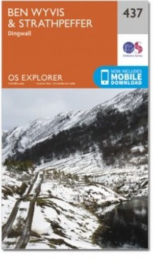
Wandelkaart 437 Ben Wyvis & Strathpeffer Schotland - OSI • 9780319472897
Wandelkaart Ben Wyvis & Strathpeffer - Highland Schotland Omvat ook: Dingwall. Productbeschrijving: OS Explorer kaart 437 toont de stad van Dingwall naar het noorden via Easter Ross, en omvat een paar Lochs en pieken. De valleien hebben de neiging om zwaar bebost te zijn, hoewel er sporen en paden (trails) lopen die het grootste deel van de regio omvatten. De OS Explorer kaart voor Ben…