

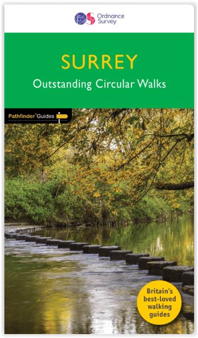
Wandelgids 065 Pathfinder guides Surrey England - OS
28 beautiful walks across Surrey

Korte omschrijving
Wandelgidsen Surrey South England van Ordnance Survey. Ideaal voor tochten in England.
Wandelgids Surrey England - OS Productomschrijving: Get lost in these 28 beautiful walks across Surrey with the OS Pathfinder Guidebooks, graded by length and ranging from 3 to 9.5 miles. T...

Specificaties
- Uitgever: Ordnance Survey
- ISBN-13: 9780319090206
- HOOFDCATEGORIEËN: Wandelgids
- Activiteiten: Wandelen, Hiking & Trekking
- Auteur: Deborah King
- Regio: Surrey South England
- Land: England
- Taal: Engels
- Reeks/Serie: Outstanding Circular Walks, Pathfinder Series, OS
- De Engelse Graafschappen: Surrey
Volledige omschrijving
Wandelgids Surrey England - OS
Productomschrijving: Get lost in these 28 beautiful walks across Surrey with the OS Pathfinder Guidebooks, graded by length and ranging from 3 to 9.5 miles. The routes range from extended strolls to longer hikes, something for all levels! The Surrey Pathfinder is tried and tested by seasoned walkers - it's ideal for both visitors and locals.
Each walk includes a detailed description, an OS map, GPS waypoints, and notes of key features and things to see. Routes include in the book include Farley Heath, the Churt Valley, Box Hill Aldbury Park, and Chobham Common. It's the perfect way to discover more of the surrey countryside.
This is one of a series of books with great walking routes covering the most popular and scenic areas of Britain.
Overzichtskaarten

Overzicht Pathfinder guides - OS
Overzicht Pathfinder guides - OS

Producten op de overzichtskaart
Klik op een product om naar de detailpagina te gaan.
- Wandelgids 001 Pathfinder guides South Devon & Dartmoor NP - OS
- Wandelgids 003 Pathfinder guides Isle of Skye - OS
- Wandelgids 004 Pathfinder guides Cairngorms NP - OS
- Wandelgids 005 Pathfinder guides Cornwall England - OS
- Wandelgids 006 Pathfinder guides Cotswolds AONB - OS
- Wandelgids 007 Pathfinder guides Fort William & Glen Coe - OS
- Wandelgids 008 Pathfinder guides Kent - OS
- Wandelgids 009 Pathfinder guides Exmoor NP & the Quantocks - OS
- Wandelgids 010 Pathfinder guides Snowdonia NP Wales - OS
- Wandelgids 011 Pathfinder guides Dorset England - OS
- Wandelgids 012 Pathfinder New Forest & South Downs NP Hampshire
- Wandelgids 015 Pathfinder guides Yorkshire Dales NP - OS
- Wandelgids 018 Pathfinder guides Brecon Beacons Wales - OS
- Wandelgids 019 Pathfinder guides Dumfries & Galloway - OS
- Wandelgids 020 Pathfinder guides Sherwood Forest - OS
- Wandelgids 022 Pathfinder guides More Lake District - OS
- Wandelgids 023 Pathfinder guides Loch Lomond, Trossachs NP - OS
- Wandelgids 025 Pathfinder guides Thames Valley & Chilterns - OS
- Wandelgids 026 Pathfinder guides Dartmoor National Park - OS
- Wandelgids 027 Pathfinder Perthshire "big county" Angus & Five OS
- Wandelgids 028 Pathfinder guides North York Moors NP - OS
- Wandelgids 029 Pathfinder guides Wye Valley AONB & Forrest of Dean
- Wandelgids 030 Pathfinder guides Loch Ness & Iverness - OS
- Wandelgids 031 Pathfinder guides Oban, Mull & Kintyre - OS
- Wandelgids 034 Pathfinder guides Pembrokeshire Wales - OS
- Wandelgids 035 Pathfinder guides Northumberland- Scottish Borders
- Wandelgids 039 Pathfinder Durham, North Pennines & Tyne & Wear OS
- Wandelgids 041 Pathfinder guides Central Wales - OS
- Wandelgids 042 Pathfinder guides Cheshire England - OS
- Wandelgids 044 Pathfinder guides Essex England - OS
- Wandelgids 045 Pathfinder guides Norfolk - OS
- Wandelgids 046 Pathfinder guides Aberdeen & Royal Deeside - OS
- Wandelgids 047 Pathfinder Edinburgh, Pentlands & Lothians - OS
- Wandelgids 048 Pathfinder guides Suffolk East England - OS
- Wandelgids 049 Pathfinder guides Vale of York East England - OS
- Wandelgids 050 Pathfinder guides Lincolnshire & the Wolds - OS
- Wandelgids 051 Pathfinder guides Cambridgeshire & The Fens - OS
- Wandelgids 053 Pathfinder guides Lancashire NW En England - OS
- Wandelgids 054 Pathfinder guides Hertfordshire & Bedfordshire- OS
- Wandelgids 055 Pathfinder guides Gower, Swansea & Cardiff - OS
- Wandelgids 060 Pathfinder guides Lake District NP - OS
- Wandelgids 063 Pathfinder guides Peak District England - OS
- Wandelgids 064 Pathfinder guides South Pennines - OS
- Wandelgids 065 Pathfinder guides Surrey England - OS
- Wandelgids 066 Pathfinder guides West Sussex & South Downs - OS
- Wandelgids 067 Pathfinder guides South Downs NP & East Sussex- OS
- Wandelgids 068 Pathfinder guides Devon North & Mid - OS
- Wandelgids 069 Pathfinder guides South West England Coastal walks
- Wandelgids 071 Pathfinder guides High Fells of Lakeland - OS
- Wandelgids 073 Pathfinder guides More Peak District - OS
Artikelen uit dezelfde regio
Wandelkaart 145 Guildford & Farnham- Surrey - OSI • 9780319243381
Wandelkaart Guildford & Farnham- Surrey England Productbeschrijving: Guildford & Farnham- Surrey zijn plaatsen in het bestuurlijke gebied Guildford, in het Engelse graafschap Surrey. 145 / Guildford & Farnham, Surrey, England - Kaart nummer 145 is een all purpose kaart vol gepakt met informatie om u het gebied te helpen leren kennen. De 204 Landranger-kaarten bestrijken het land. Elke …

Fietsgids Cycling Days Out - South East England - Vertebrate Publ • 9781906148249
Cycling Days Out - South East England - Vertebrate Productomschrijving: Traffic-free family and leisure cycling in Kent, Sussex, Surrey & Hampshire. Cycling Days Out – South East England is a guide to traffic-free family and leisure cycling in Kent, Sussex, Surrey and Hampshire. Written by local author Deirdre Huston, it explores tourist trails, country parks, forest riding and more. …

Wandelkaart 146 Dorking- Box Hill & Reigate- Surrey - OSI • 9780319243398
Wandelkaart Dorking- Box Hill & Reigate - Surrey England Productbeschrijving: Leatherhead & Caterham. 146 / Dorking, Box Hill & Reigate, Surrey, England - Kaart nummer 146 in de OS Explorer reeks omvat Reigate, Leatherhead, Caterham, Dorking, Gatwick Airport, Redhill, Horley, Box Hill, Warlingham en Couldson. Hoogtepunten van het gebied zijn onder andere: Surrey Hills AONB, het E2-pad …

Wandelgids - North Downs Way - Map Booklet - Cicerone • 9781852849559
Wandelgids - North Downs Way - Map Booklet - Cicerone Productomschrijving: Kaart van de 208km, over de North Downs Way National Trail, tussen Farnham en Dover, met inbegrip van een optioneel bezoek aan Canterbury. Dit boekje is opgenomen in de Cicerone gids en toont het volledige parcours op OS 1: 25.000 kaarten. Een van de eenvoudigere nationale routes, dat comfortabel kan worden gelopen …

Fietsgids Cycling in Surrey England - Bradt Travel guides • 9781804691359
Cycling in Surrey - Bradt Travel guides Productomschrijving: De nieuwe fietsgids voor Surrey - is onderdeel van een groeiende serie ontworpen voor in de zadeltas - biedt 21 routes, elk inclusief uitgebreide routebeschrijvingen plus contextuele verkenning van geschiedenis, natuur en cultuur, geschreven door fervent fietser en historicus Ross Hamilton. Elke route is gekoppeld aan OS Explorer…