

Wandelgids 030 Pathfinder guides Loch Ness & Iverness - OS
Moray Firth - Fort Augustus - Glen Affric - Caithness


Korte omschrijving
Wandelgidsen Northern Highland's, Schotland en Highlands, Schotland van Ordnance Survey. Ideaal voor tochten in Schotland.
Wandelgids Loch Ness & Iverness Schotland - OS Productomschrijving: The area covered by this guide centres on the Highland 'capital' of Inverness, and extends north and east along the shore...

Specificaties
- Uitgever: Ordnance Survey
- ISBN-13: 9780319090817
- HOOFDCATEGORIEËN: Wandelgids
- Activiteiten: Wandelen, Hiking & Trekking
- Regio: Highlands, Schotland, Northern Highland's, Schotland
- Land: Schotland
- Taal: Engels
- Reeks/Serie: Outstanding Circular Walks, Pathfinder Series, OS
- Iconische Bergketens van Europa: De Schotse Highlands
Volledige omschrijving
Wandelgids Loch Ness & Iverness Schotland - OS
Productomschrijving: The area covered by this guide centres on the Highland 'capital' of Inverness, and extends north and east along the shores of the Moray Firth, and south and west to Fort Augustus and Glen Affric, encompassing Caithness, eastern Sutherland, Easter Ross, the Black Isle, Moray and the banks of Loch Ness.
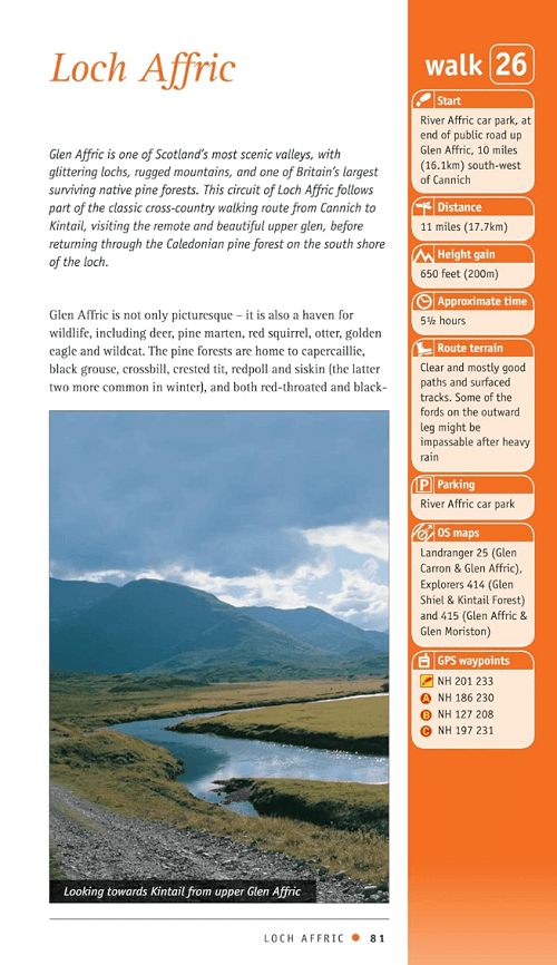
With coastal walks including a route through classic Caithness scenery at Noss Head. Inland, ascents to Ben Rinnes and Ben Wyvis provide panoramic views of the surrounding area and opportunities to see rare alpine flora, and a route via Loch Affric reveals some of Scotland's most magnificent scenery.
Overzichtskaarten

Overzicht Pathfinder guides - OS
Overzicht Pathfinder guides - OS

Producten op de overzichtskaart
Klik op een product om naar de detailpagina te gaan.
- Wandelgids 001 Pathfinder guides South Devon & Dartmoor NP - OS
- Wandelgids 003 Pathfinder guides Isle of Skye - OS
- Wandelgids 004 Pathfinder guides Cairngorms NP - OS
- Wandelgids 005 Pathfinder guides Cornwall England - OS
- Wandelgids 006 Pathfinder guides Cotswolds AONB - OS
- Wandelgids 007 Pathfinder guides Fort William & Glen Coe - OS
- Wandelgids 008 Pathfinder guides Kent - OS
- Wandelgids 009 Pathfinder guides Exmoor NP & the Quantocks - OS
- Wandelgids 010 Pathfinder guides Snowdonia NP Wales - OS
- Wandelgids 011 Pathfinder guides Dorset England - OS
- Wandelgids 012 Pathfinder New Forest & South Downs NP Hampshire
- Wandelgids 015 Pathfinder guides Yorkshire Dales NP - OS
- Wandelgids 018 Pathfinder guides Brecon Beacons Wales - OS
- Wandelgids 019 Pathfinder guides Dumfries & Galloway - OS
- Wandelgids 020 Pathfinder guides Sherwood Forest - OS
- Wandelgids 022 Pathfinder guides More Lake District - OS
- Wandelgids 023 Pathfinder guides Loch Lomond, Trossachs NP - OS
- Wandelgids 025 Pathfinder guides Thames Valley & Chilterns - OS
- Wandelgids 026 Pathfinder guides Dartmoor National Park - OS
- Wandelgids 027 Pathfinder Perthshire "big county" Angus & Five OS
- Wandelgids 028 Pathfinder guides North York Moors NP - OS
- Wandelgids 029 Pathfinder guides Wye Valley AONB & Forrest of Dean
- Wandelgids 030 Pathfinder guides Loch Ness & Iverness - OS
- Wandelgids 031 Pathfinder guides Oban, Mull & Kintyre - OS
- Wandelgids 034 Pathfinder guides Pembrokeshire Wales - OS
- Wandelgids 035 Pathfinder guides Northumberland- Scottish Borders
- Wandelgids 039 Pathfinder Durham, North Pennines & Tyne & Wear OS
- Wandelgids 041 Pathfinder guides Central Wales - OS
- Wandelgids 042 Pathfinder guides Cheshire England - OS
- Wandelgids 044 Pathfinder guides Essex England - OS
- Wandelgids 045 Pathfinder guides Norfolk - OS
- Wandelgids 046 Pathfinder guides Aberdeen & Royal Deeside - OS
- Wandelgids 047 Pathfinder Edinburgh, Pentlands & Lothians - OS
- Wandelgids 048 Pathfinder guides Suffolk East England - OS
- Wandelgids 049 Pathfinder guides Vale of York East England - OS
- Wandelgids 050 Pathfinder guides Lincolnshire & the Wolds - OS
- Wandelgids 051 Pathfinder guides Cambridgeshire & The Fens - OS
- Wandelgids 053 Pathfinder guides Lancashire NW En England - OS
- Wandelgids 054 Pathfinder guides Hertfordshire & Bedfordshire- OS
- Wandelgids 055 Pathfinder guides Gower, Swansea & Cardiff - OS
- Wandelgids 060 Pathfinder guides Lake District NP - OS
- Wandelgids 063 Pathfinder guides Peak District England - OS
- Wandelgids 064 Pathfinder guides South Pennines - OS
- Wandelgids 065 Pathfinder guides Surrey England - OS
- Wandelgids 066 Pathfinder guides West Sussex & South Downs - OS
- Wandelgids 067 Pathfinder guides South Downs NP & East Sussex- OS
- Wandelgids 068 Pathfinder guides Devon North & Mid - OS
- Wandelgids 069 Pathfinder guides South West England Coastal walks
- Wandelgids 071 Pathfinder guides High Fells of Lakeland - OS
- Wandelgids 073 Pathfinder guides More Peak District - OS
Artikelen uit dezelfde regio
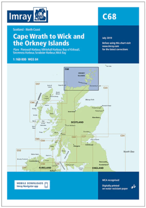
Passage kaart C068 Cape Wrath tot Wick en de Orkney-eilanden • 9781846239298
PassagekaartCape Wrath tot Wick en de Orkney-eilanden - Imray (F&B) Productomschrijving: De noordkust van Schotland van Cape Wrath tot Wick, inclusief de Pentland Firth en de Orkney-eilanden. Grotere schaalplannen van Pierowall, Kirkwall, Whitehall Harbour, Wick Bay, Stromness en Scrabster. Op schaal 1: 160.000 De Imray Charts C-serie bestrijken vaargebieden in Noordwest-Europa, en…

Wandelkaart 414 Glen Shiel & Kintail Forest- Highlands- OSI • 9780319246498
Wandelkaart Glen Shiel & Kintail Forest - Highlands Schotland Omvat ook: Shiel Bridge, Morvich, Killilan & Kinloch Hourn. 414 / Glen Shiel & Kintail Forest, Highlands, Schotland - Als u van plan bent om zoveel Munros op zak te steken, gaat u deze OS Explorer kaart 414 nodig hebben. Met 32 Munros op een dubbelzijdige kaart heeft dit gebied ook drie nationale natuurgebieden, Loch Cluanie…

Wandelkaart 391 Ardgour & Strontian- Highlands - OSI • 9780319246344
Wandelkaart Ardgour & Strontian - Highlands Schotland Productbeschrijving: Glenfinnan, Loch Eil & Loch Shiel 391 Ardgour / Strontian, Highlands Schotland - Kaart nummer 391 in de OS Explorer kaart reeks is ideaal voor ontdekken van het gebied in de buurt van Ben Nevis. Loch Linnhe, en ligt ten westen van Ben Nevis en Glen Coe met prachtige landschappen en uitdagende wandelingen, die er…
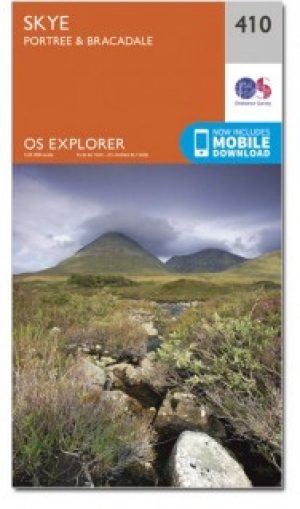
Wandelkaart 410 Isle of Skye- Portree & Bracadale - OSI • 9780319246450
Wandelkaart Isle of Skye - Portree & Bracadale Schotland Productbeschrijving: Kaart nummer 410 in de OS Explorer kaarten reeks is de perfecte kaart om te gebruiken bij een bezoek aan "The Isle of Skye". Het eiland is een geweldige locatie voor een ontspannen vakantie of voor een actieve vakantie voor fietsers, wandelaars en outdoor enthousiastelingen. Hoogtepunten van het gebied zijn onder…
Wandelkaart 19 Gairloch & Ullapool- Highland's Schotland - OSI • 9780319473429
Wandelkaart Gairloch Ullapool - Highland's Schotland Productomschrijving: Gairloch is een plaats aan de noordwestkust van Schotland. De locatie aan de oever van Loch Gairloch is een populaire zomer toeristische badplaats. Het biedt wandelen, een golfbaan en een klein museum. Talloze kleine meren in het gebied zijn populaire bestemmingen van forel -Fischern. Voordat Gairlochs kust van het e…