

Wandelgids 028 Pathfinder guides North York Moors NP - OS
Robin Hood's Bay- Rievaulx Abbey- River Esk valley
Korte omschrijving
Wandelgidsen North Yorkshire, Engeland van Ordnance Survey. Ideaal voor tochten in England.
Wandelgids North York Moors National Park - OS Productomschrijving: The Pathfinder guidebook for The North York Moors is designed to help you make the most of your time in the area. It cont...

Specificaties
- Uitgever: Ordnance Survey
- ISBN-13: 9780319090251
- HOOFDCATEGORIEËN: Wandelgids
- Activiteiten: Wandelen, Hiking & Trekking
- Regio: North Yorkshire, Engeland
- Land: England
- Nationale parken: North York Moors NP, England
- Taal: Engels
- Reeks/Serie: Outstanding Circular Walks, Pathfinder Series, OS
- De Nationale Parken: North Yorkshire Moors National Park, England
- De Engelse Graafschappen: North Yorkshire
Volledige omschrijving
Wandelgids North York Moors National Park - OS
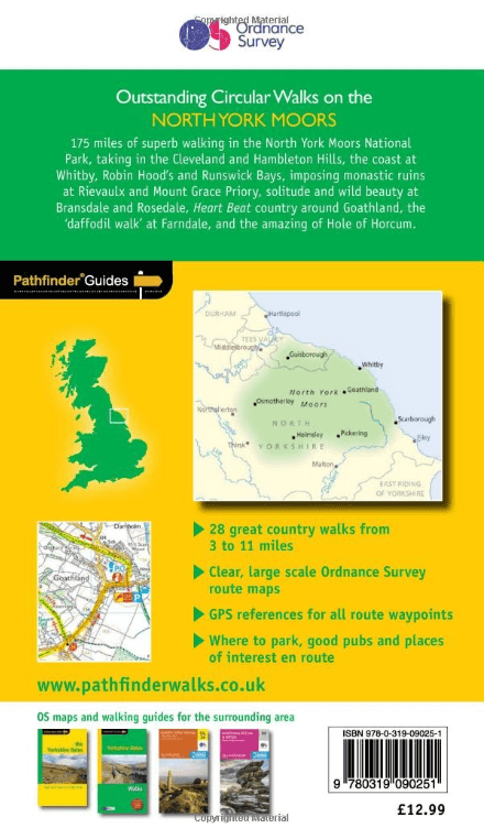
Productomschrijving: The Pathfinder guidebook for The North York Moors is designed to help you make the most of your time in the area. It contains 28 walks, each graded by difficulty and ranging from 3.5 miles up to 11 miles in length. All the routes are created by seasoned walkers, and designed to help you make the most of the area.
Highlights of The North York Moors available on these walks include Robin Hood's Bay, Rievaulx Abbey, the River Esk valley and the Cook Monument. Routes across wild and remote moorland, such has Ingleby Moor, Westerdale Moor and Ainthorpe Rigg are contrasted with coastal and clifftop walks around Runswick Bay and Staithes, Whitby and Saltwick Bay and Ravenscar.
Each walking route has a description, and extract of the OS map to keep you on course and notes with highlights of the area.
Overzichtskaarten

Overzicht Pathfinder guides - OS
Overzicht Pathfinder guides - OS

Producten op de overzichtskaart
Klik op een product om naar de detailpagina te gaan.
- Wandelgids 001 Pathfinder guides South Devon & Dartmoor NP - OS
- Wandelgids 003 Pathfinder guides Isle of Skye - OS
- Wandelgids 004 Pathfinder guides Cairngorms NP - OS
- Wandelgids 005 Pathfinder guides Cornwall England - OS
- Wandelgids 006 Pathfinder guides Cotswolds AONB - OS
- Wandelgids 007 Pathfinder guides Fort William & Glen Coe - OS
- Wandelgids 008 Pathfinder guides Kent - OS
- Wandelgids 009 Pathfinder guides Exmoor NP & the Quantocks - OS
- Wandelgids 010 Pathfinder guides Snowdonia NP Wales - OS
- Wandelgids 011 Pathfinder guides Dorset England - OS
- Wandelgids 012 Pathfinder New Forest & South Downs NP Hampshire
- Wandelgids 015 Pathfinder guides Yorkshire Dales NP - OS
- Wandelgids 018 Pathfinder guides Brecon Beacons Wales - OS
- Wandelgids 019 Pathfinder guides Dumfries & Galloway - OS
- Wandelgids 020 Pathfinder guides Sherwood Forest - OS
- Wandelgids 022 Pathfinder guides More Lake District - OS
- Wandelgids 023 Pathfinder guides Loch Lomond, Trossachs NP - OS
- Wandelgids 025 Pathfinder guides Thames Valley & Chilterns - OS
- Wandelgids 026 Pathfinder guides Dartmoor National Park - OS
- Wandelgids 027 Pathfinder Perthshire "big county" Angus & Five OS
- Wandelgids 028 Pathfinder guides North York Moors NP - OS
- Wandelgids 029 Pathfinder guides Wye Valley AONB & Forrest of Dean
- Wandelgids 030 Pathfinder guides Loch Ness & Iverness - OS
- Wandelgids 031 Pathfinder guides Oban, Mull & Kintyre - OS
- Wandelgids 034 Pathfinder guides Pembrokeshire Wales - OS
- Wandelgids 035 Pathfinder guides Northumberland- Scottish Borders
- Wandelgids 039 Pathfinder Durham, North Pennines & Tyne & Wear OS
- Wandelgids 041 Pathfinder guides Central Wales - OS
- Wandelgids 042 Pathfinder guides Cheshire England - OS
- Wandelgids 044 Pathfinder guides Essex England - OS
- Wandelgids 045 Pathfinder guides Norfolk - OS
- Wandelgids 046 Pathfinder guides Aberdeen & Royal Deeside - OS
- Wandelgids 047 Pathfinder Edinburgh, Pentlands & Lothians - OS
- Wandelgids 048 Pathfinder guides Suffolk East England - OS
- Wandelgids 049 Pathfinder guides Vale of York East England - OS
- Wandelgids 050 Pathfinder guides Lincolnshire & the Wolds - OS
- Wandelgids 051 Pathfinder guides Cambridgeshire & The Fens - OS
- Wandelgids 053 Pathfinder guides Lancashire NW En England - OS
- Wandelgids 054 Pathfinder guides Hertfordshire & Bedfordshire- OS
- Wandelgids 055 Pathfinder guides Gower, Swansea & Cardiff - OS
- Wandelgids 060 Pathfinder guides Lake District NP - OS
- Wandelgids 063 Pathfinder guides Peak District England - OS
- Wandelgids 064 Pathfinder guides South Pennines - OS
- Wandelgids 065 Pathfinder guides Surrey England - OS
- Wandelgids 066 Pathfinder guides West Sussex & South Downs - OS
- Wandelgids 067 Pathfinder guides South Downs NP & East Sussex- OS
- Wandelgids 068 Pathfinder guides Devon North & Mid - OS
- Wandelgids 069 Pathfinder guides South West England Coastal walks
- Wandelgids 071 Pathfinder guides High Fells of Lakeland - OS
- Wandelgids 073 Pathfinder guides More Peak District - OS
Artikelen uit dezelfde regio

Wandelkaart OL26 North York Moors Western area - OSI • 9780319469446
Wandelkaart North York Moors - North Yorkshire England Productbeschrijving: Kaart nummer OL26 in de OS Explorer reeks heeft betrekking op de Cleveland Hills, het westelijke deel van de North York Moors en een klein deel van de Howardian hills. Hoogtepunten van het gebied zijn onder andere: Saltburn-by-the-Sea, Guisborough, Helmsley en Hunt Topping. Productdiscription: Map sheet number …

Wandelkaart 94 Whitby & Esk Dale- North Yorkshire - OSI • 9780319474174
Wandelkaart Whitby & Esk Dale - North Yorkshire England Productbeschrijving: Kaart OS Landranger 94 toont het meeste van het North York Moors National Park, en omvat Robin Hoods Bay, Whitby en Saltburn-by-the-Sea. De Esk Dale is een schilderachtige vallei - Volg de Esk Valley Walk (56km aan het einde) om het beste van dit gebied te zien. De kust stad van Whitby is waarschijnlijk het meest …

Wandelkaart 297 Lower Wharfedale & Washburn Valley - OSI • 9780319245491
Wandelkaart Lower Wharfedale & Washburn Valley - North Yorkshire Omvat ook: Harrogate & Ilkley Moor Productomschrijving: Kaart nummer 297 in de OS Explorer kaarten reeks heeft betrekking op het Nidderdale AONB en het Yorkshire Dales National Park. De stad van Harrogate is omgeven door het Harrogate Ringway recreatief pad, terwijl de Dales Way loopt langs Ilkley, Otley en Guisely. Ander…
Wandelgids Trekking the Coast to Coast Path - Knife Edge • 9781912933143
Trekking the Coast to Coast Path - Knife Edge Productomschrijving: Deze beroemde wandelroute van om en bij de 290 km, loopt door 3 nationale parken, 3 wereldbekende nationale parken die elk appart hun eigen specifieke voordelen bieden. Route: St-Beest to Robin Hood's Bay Engelse omschrijving: The definitive two-way guide to the Coast to Coast Path: both eastbound and westbound rou…

Wandelkaart 101 Scarborough- Bridlington & Filey - OSI • 9780319474242
Wandelkaart Scarborough- Bridlington & Filey - North Yorkshire Productbeschrijving: Kaart OS Landranger 101 beslaat de kust stad van Scarborough, evenals de zuidoostelijke hoek van het North York Moors National Park. De Wolds Way en Cleveland way (onderdeel van het Europese lange pad E2) ontmoeten hier, en u vindt er ook de steden Bridlington en Filey. Hoogtepunten van het gebied zijn het …