

Wandelgids 042 Pathfinder guides Cheshire England - OS
hropshire Union Canal - Delamare Forest - Little Moreton Hall

Korte omschrijving
Wandelgidsen Cheshire, England van Ordnance Survey. Ideaal voor tochten in England.
Wandelgids Cheshire - OS Productomschrijving: This walking guidebook for Cheshire contains 28 outstanding walks all tried and tested by experienced walkers. The routes range from extended s...

Specificaties
- Uitgever: Ordnance Survey
- ISBN-13: 9780319090312
- HOOFDCATEGORIEËN: Wandelgids
- Activiteiten: Wandelen, Hiking & Trekking
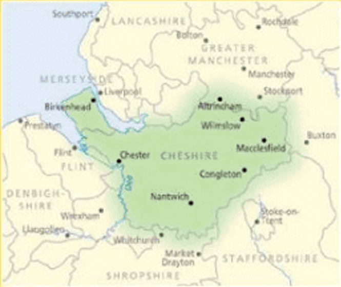
- Regio: Cheshire, England
- Land: England
- Taal: Engels
- Reeks/Serie: Outstanding Circular Walks, Pathfinder Series, OS
- De Engelse Graafschappen: Cheshire
Volledige omschrijving
Wandelgids Cheshire - OS
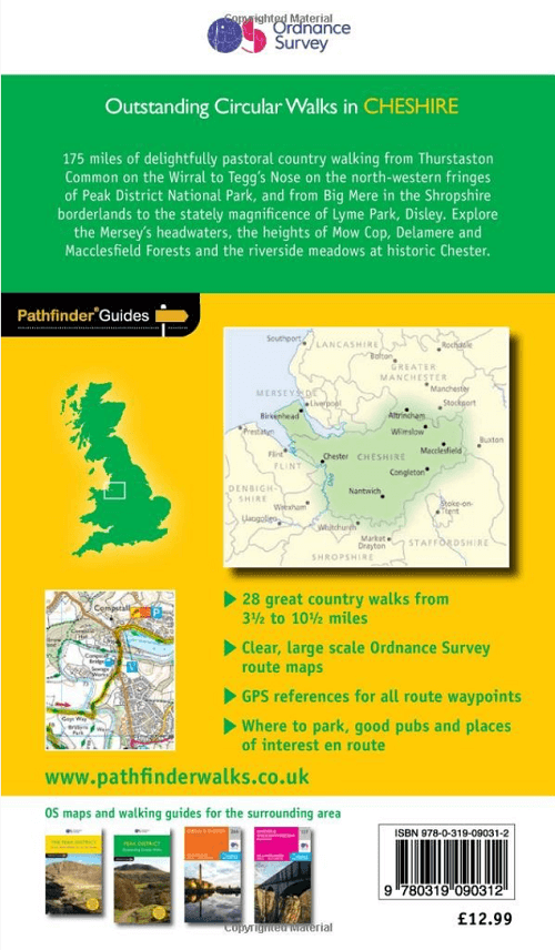
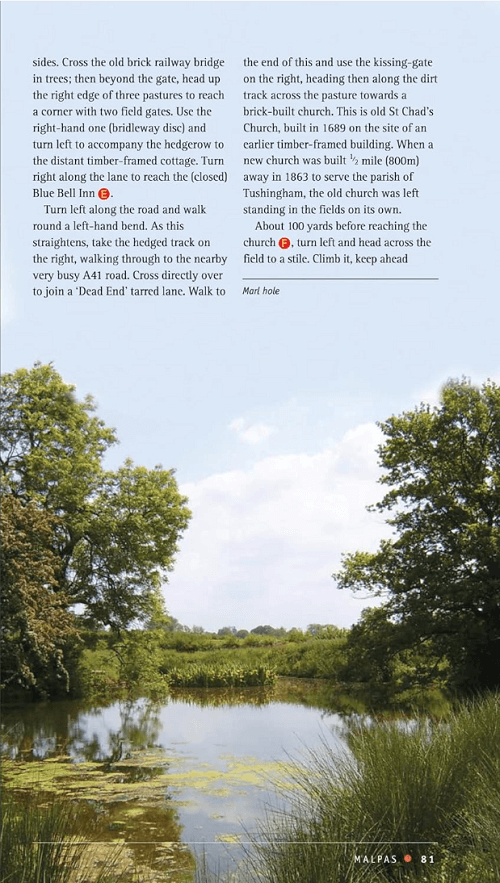
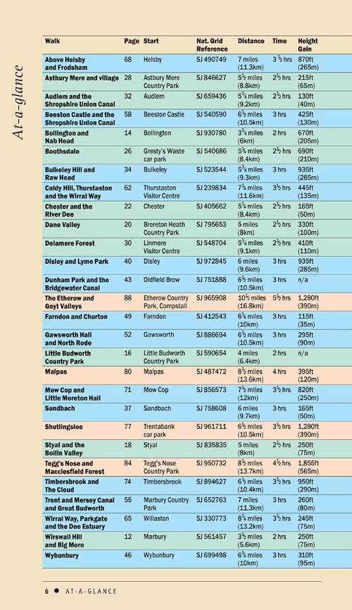
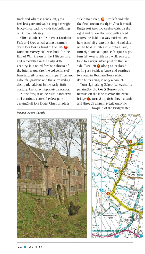
Productomschrijving: This walking guidebook for Cheshire contains 28 outstanding walks all tried and tested by experienced walkers. The routes range from extended strolls to exhilarating hikes - four to eleven miles in length. Each walk includes a detailed description of both the route and the areas you will pass through, as well as an extract of the OS map for the route. They include routes visiting the Shropshire Union Canal, the Delamare Forest, Little Moreton Hall and the hilltop village of Wybunbury.
This book is part of a series of Pathfinder walking guidebooks designed to help both visitors and locals discover the best routes each area has to offer.
Overzichtskaarten

Overzicht Pathfinder guides - OS
Overzicht Pathfinder guides - OS

Producten op de overzichtskaart
Klik op een product om naar de detailpagina te gaan.
- Wandelgids 001 Pathfinder guides South Devon & Dartmoor NP - OS
- Wandelgids 003 Pathfinder guides Isle of Skye - OS
- Wandelgids 004 Pathfinder guides Cairngorms NP - OS
- Wandelgids 005 Pathfinder guides Cornwall England - OS
- Wandelgids 006 Pathfinder guides Cotswolds AONB - OS
- Wandelgids 007 Pathfinder guides Fort William & Glen Coe - OS
- Wandelgids 008 Pathfinder guides Kent - OS
- Wandelgids 009 Pathfinder guides Exmoor NP & the Quantocks - OS
- Wandelgids 010 Pathfinder guides Snowdonia NP Wales - OS
- Wandelgids 011 Pathfinder guides Dorset England - OS
- Wandelgids 012 Pathfinder New Forest & South Downs NP Hampshire
- Wandelgids 015 Pathfinder guides Yorkshire Dales NP - OS
- Wandelgids 018 Pathfinder guides Brecon Beacons Wales - OS
- Wandelgids 019 Pathfinder guides Dumfries & Galloway - OS
- Wandelgids 020 Pathfinder guides Sherwood Forest - OS
- Wandelgids 022 Pathfinder guides More Lake District - OS
- Wandelgids 023 Pathfinder guides Loch Lomond, Trossachs NP - OS
- Wandelgids 025 Pathfinder guides Thames Valley & Chilterns - OS
- Wandelgids 026 Pathfinder guides Dartmoor National Park - OS
- Wandelgids 027 Pathfinder Perthshire "big county" Angus & Five OS
- Wandelgids 028 Pathfinder guides North York Moors NP - OS
- Wandelgids 029 Pathfinder guides Wye Valley AONB & Forrest of Dean
- Wandelgids 030 Pathfinder guides Loch Ness & Iverness - OS
- Wandelgids 031 Pathfinder guides Oban, Mull & Kintyre - OS
- Wandelgids 034 Pathfinder guides Pembrokeshire Wales - OS
- Wandelgids 035 Pathfinder guides Northumberland- Scottish Borders
- Wandelgids 039 Pathfinder Durham, North Pennines & Tyne & Wear OS
- Wandelgids 041 Pathfinder guides Central Wales - OS
- Wandelgids 042 Pathfinder guides Cheshire England - OS
- Wandelgids 044 Pathfinder guides Essex England - OS
- Wandelgids 045 Pathfinder guides Norfolk - OS
- Wandelgids 046 Pathfinder guides Aberdeen & Royal Deeside - OS
- Wandelgids 047 Pathfinder Edinburgh, Pentlands & Lothians - OS
- Wandelgids 048 Pathfinder guides Suffolk East England - OS
- Wandelgids 049 Pathfinder guides Vale of York East England - OS
- Wandelgids 050 Pathfinder guides Lincolnshire & the Wolds - OS
- Wandelgids 051 Pathfinder guides Cambridgeshire & The Fens - OS
- Wandelgids 053 Pathfinder guides Lancashire NW En England - OS
- Wandelgids 054 Pathfinder guides Hertfordshire & Bedfordshire- OS
- Wandelgids 055 Pathfinder guides Gower, Swansea & Cardiff - OS
- Wandelgids 060 Pathfinder guides Lake District NP - OS
- Wandelgids 063 Pathfinder guides Peak District England - OS
- Wandelgids 064 Pathfinder guides South Pennines - OS
- Wandelgids 065 Pathfinder guides Surrey England - OS
- Wandelgids 066 Pathfinder guides West Sussex & South Downs - OS
- Wandelgids 067 Pathfinder guides South Downs NP & East Sussex- OS
- Wandelgids 068 Pathfinder guides Devon North & Mid - OS
- Wandelgids 069 Pathfinder guides South West England Coastal walks
- Wandelgids 071 Pathfinder guides High Fells of Lakeland - OS
- Wandelgids 073 Pathfinder guides More Peak District - OS
Artikelen uit dezelfde regio
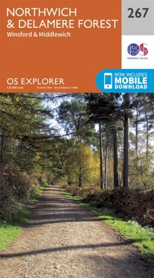
Wandelkaart 267 Northwich & Delamere Forest - OSI • 9780319244647
Wandelkaart Northwich & Delamere Forest - Cheshire England Omvat ook: Winsford & Middlewich Productomschrijving: De Mersey Forest omvat Northwich, Winsford en Delamere Forest. Met routes om te wandelen, fietsen en om te paardrijden, er zijn ook evenementen het hele jaar door. De OS Explorer kaart voor Northwich & Delamere Forest is beschikbaar in zowel de standaard papieren versie als …

Wandelkaart 117 Chester & Wrexham - West Cheshire - OSI • 9780319262153
Wandelkaart Chester & Wrexham - West Cheshire England - OSI Productbeschrijving: Kaart nummer 117 in de OS Landranger kaarten reeks beslaat een gebied van Llangollen in het zuiden aan Ellesmere Port in het noorden met Chester, die ligt aan de rivier de Dee. De belangrijkste bezienswaardigheden van de stad zijn Chester Zoo en de renbaan. Een korte reis naar het noorden brengt u naar de grot…

Wandelkaart 267 Northwich & Delamere Forest - OSI • 9780319471395
Wandelkaart Northwich & Delamere Forest - Cheshire England Omvat ook: Winsford & Middlewich. Productbeschrijving: De Mersey Forest covers Northwich, Winsford en Delamere Forest. Met vele routes om te wandelen, te fietsen en te paardrijden, er zijn ook vele evenementen gedurende het hele jaar. De OS Explorer kaart voor Northwich & Delamere Forest is beschikbaar in zowel de standaard pap…

Wandelkaart 268 Wilmslow- Macclesfield & Congleton - OSI • 9780319244654
Wandelkaart Wilmslow- Macclesfield & Congleton Omvat ook: Altrincham, Knutsford & Sandbach. Productbeschrijving: Kaart nummer 268 in de OS Explorer kaarten reeks omvat Wilmslow, Macclesfield & Congleton tussen Stoke-on-Trent en Manchester. Er zijn een heleboel recreatieve paden in dit gebied, met inbegrip van de Gritstone Trail, Dane Valley Way en de Trans Pennine Trail. Het gebied omv…

Wandelkaart 117 Chester & Wrexham - Ellesmere Port - OSI • 9780319474402
Wandelkaart Chester & Wrexham- Ellesmere Por - West Cheshire Productbeschrijving: De OS Landranger kaarten reeks heeft betrekking op Groot-Brittannië met 204 gedetailleerde kaarten, perfect voor dagtochten en korte pauzes. Elke kaart bevat alle informatie die u nodig heeft om dit lokaal gebied te leren kennen en omvat plaatsen van belang, toeristische informatie, picknickplaatsen en campin…