

Wandelkaart 221 Coventry & Warwickshire - OSI
Omvat Coventry- Warwick & Royal Leamington Spa


Korte omschrijving
Wandelkaarten Warwickshire, West Midlands van Ordnance Survey. Ideaal voor tochten in England.
Wandelkaart Coventry & Warwickshire - England Productbeschrijving: Royal Leamington Spa & Kenilworth. 221 / Coventry & Warwickshire, England - OS Explorer kaart 221 dekt Coventry, Warwi...

Specificaties
- Uitgever: Ordnance Survey
- ISBN-13: 9780319244142
- HOOFDCATEGORIEËN: Wandelkaart
- Activiteiten: Wandelen, Hiking & Trekking
- Regio: Warwickshire, West Midlands
- Land: England
- TOPO's & Stafkaarten: Topografisch wandelen
- Schaal: 1:25000
- Taal: Engels
- Reeks/Serie: Explorer Series OS
- De Engelse Graafschappen: Warwickshire
Volledige omschrijving
Wandelkaart Coventry & Warwickshire - England
Productbeschrijving: Royal Leamington Spa & Kenilworth.
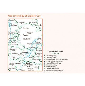
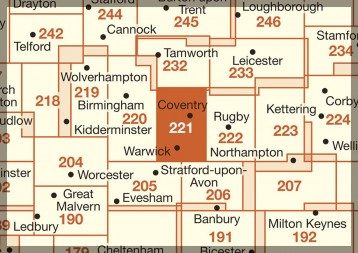
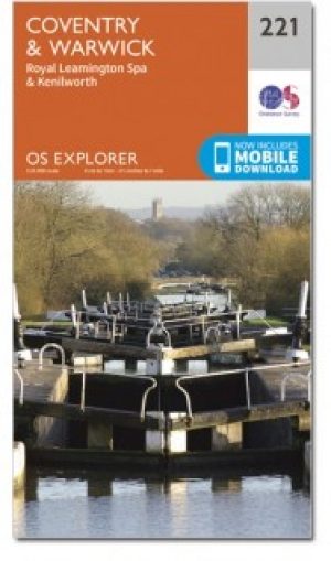
221 / Coventry & Warwickshire, England - OS Explorer kaart 221 dekt Coventry, Warwick, Royal Leamington Spa en de omliggende gebieden. Warwick Castle en vervolgens de rivier de Avon en Fort Lunt Roamn in de buurt van Coventry. De OS Explorer kaart voor Coventry & Warwick is beschikbaar in zowel de standaard papieren versie als de weerbestendige 'Actief' versie.
221 / Coventry & Warwickshire, England - OS Explorer Map sheet 221 covers Coventry, Warwick, Royal Leamington Spa and the surrounding areas. Explore Warwick Castle, and then continue your adventure up the River Avon, or visit the Roamn Lunt Fort near Coventry. The OS Explorer map for Coventry & Warwick is available in both the standard paper version and weatherproof 'Active' version.
Locatie op kaart
Gekoppelde artikelen
Wandelkaart 221 Coventry & Warwickshire - OSI • 9780319244142
standaard versieWandelkaart Coventry & Warwickshire - England Productbeschrijving: Royal Leamington Spa & Kenilworth. 221 / Coventry & Warwickshire, England - OS Explorer kaart 221 dekt Coventry, Warwick, Royal Leamington Spa en de omliggende gebieden. Warwick Castle en vervolgens de rivier de Avon en Fort Lunt Roamn in de buurt van Coventry. De OS Explorer kaart voor Coventry & Warwick is beschikbaa…

Wandelkaart 221 Coventry & Warwick- West Midlands - OSI • 9780319470930
weatherproof versieWandelkaart Coventry & Warwick - West Midlands England Productbeschrijving: OS Explorer kaart 221 omvat Coventry, Warwick, Royal Leamington Spa en de omliggende gebieden. Ontdek Warwick Castle, en zet vervolgens uw avontuur door langs de rivier de Avon, of bezoek het Fort Lunt Roamn in de buurt van Coventry. De OS Explorer kaart voor Coventry & Warwick is beschikbaar in zowel de standaard …
Overzichtskaarten

OSI Explorer & Explorer Active - Midden Engeland - Midlands
OSI Explorer & Explorer Active - Midden Engeland - Midlands

Producten op de overzichtskaart
Klik op een product om naar de detailpagina te gaan.
- Wandelkaart 180 Oxford- England - OSI
- Wandelkaart 181 Chiltern Hills North AONB- Wycombe - OSI
- Wandelkaart 182 St-Albans & Hatfield- Hertfordshire - OSI
- Wandelkaart 189 Hereford & Ross-on-Wye- England - OSI
- Wandelkaart 190 Malvern Hills AONB & Bredon Hill - OSI
- Wandelkaart 191 Banbury- Bicester & Chipping Norton- OSI
- Wandelkaart 192 Buckingham & Milton Keynes - OSI
- Wandelkaart 193 Luton & Stevenage- Bedfordshire - OSI
- Wandelkaart 194 Hertford & Bishop's Stortford - OSI
- Wandelkaart 202 Leominster & Bromyard Hererfordshire - OSI
- Wandelkaart 203 Ludlow & Shropshire Hills AONB - OSI
- Wandelkaart 204 Worcester & Droitwich Spa - OSI
- Wandelkaart 205 Stratford-upon-Avon & Evesham - OSI
- Wandelkaart 206 Edge Hill & Fenny Compton - OSI
- Wandelkaart 207 Newport Pagnell & Northampton - OSI
- Wandelkaart 208 Bedford & St Neots- Bedforeshire - OSI
- Wandelkaart 209 Cambridge - England - OSI
- Wandelkaart 217 Long Mynd & Wenlock Edge - OSI
- Wandelkaart 218 Kidderminster & Wyre Forest - OSI
- Wandelkaart 219 Wolverhampton & Dudley - OSI
- Wandelkaart 220 Birmingham- West Midlands - OSI
- Wandelkaart 221 Coventry & Warwickshire - OSI
- Wandelkaart 222 Rugby & Daventry- Warwickshire - OSI
- Wandelkaart 223 Northampton & Market Harborough - OSI
- Wandelkaart 224 Corby- Kettering & Wellingborough - OSI
- Wandelkaart 225 Huntingdon & St Ives - OSI
- Wandelkaart 227 Peterborough- Cambridgeshire England - OSI
- Wandelkaart 228 March- Ely- Chatteris & Littleport - OSI
- Wandelkaart 232 Nuneaton & Tamworth- Warwickshire - OSI
- Wandelkaart 233 Leicester & Hinckley England - OSI
- Wandelkaart 234 Rutland Water & Stamford- Oakham - OSI
- Wandelkaart 235 Wisbech & Peterborough North - OSI
- Wandelkaart 241 Shrewsbury- shropshire England - OSI
- Wandelkaart 242 Telford- Ironbridge & the Wrekin - OSI
- Wandelkaart 243 Market Drayton- Schropshire - OSI
- Wandelkaart 244 Cannock Chase & Chasewater- Severn - OSI
- Wandelkaart 245 National Forest- Burton-upon-Trent - OSI
- Wandelkaart 245 National Forest - OSI
- Wandelkaart 246 Loughborough- Leicestershire England - OSI
- Wandelkaart 247 Grantham- Lincolnshire - OSI
- Wandelkaart 248 Bourne & Heckington- lincolnshire - OSI
- Wandelkaart 249 Spalding & Holbeach- Lincolnshire - OSI
- Wandelkaart 257 Crewe & Nantwich & Cheshire East - OSI
- Wandelkaart 258 Stoke-on-Trent & Newcastle-under-Lyme- OSI
- Wandelkaart 259 Derby & Utoxeter- Derbyshire - OSI
- Wandelkaart 260 Nottingham & Vale of Belvoir - OSI
- Wandelkaart 261 Boston & Lincolnshire- England - OSI
- Wandelkaart 267 Northwich & Delamere Forest - OSI
- Wandelkaart 268 Wilmslow- Macclesfield & Congleton - OSI
- Wandelkaart 269 Chesterfield & Alfreton- Derbyshire- OSI
- Wandelkaart 270 Sherwood Forest- Nottinghamshire - OSI
- Wandelkaart 271 Newark-on-Trent- Nottinghampshire - OSI
- Wandelkaart 272 Lincoln- England - OSI
- Wandelkaart 273 Lincolnshire Wolds South- England - OSI
- Wandelkaart 274 Skegness- Alford & Spilsby - OSI
- Wandelkaart 275 Liverpool- South West England - OSI
- Wandelkaart 276 Bolton- Wigan & Warrington- Machester - OSI
- Wandelkaart 277 Manchester & Salford - OSI
- Wandelkaart 278 Sheffield & Barnsley- South Yorkshire - OSI
- Wandelkaart 279 Doncaster- South Yorkshire - OSI
- Wandelkaart 280 Isle of Axholme- Lincolnshire - OSI
- Wandelkaart 281 Ancholme Valley- Lincolnshire - OSI
- Wandelkaart 282 Lincolnshire Wolds North- England - OSI
- Wandelkaart 283 Louth & Mablethorpe- Lincolnshire - OSI
- Wandelkaart 284 Grimsby- Cleethorpes & Immingham - OSI
- Wandelkaart OL01 Peak District NP & Dark Peak area - OS
- Wandelkaart OL13 Brecon Beacons National Parc East - OS
- Wandelkaart OL24 Peak District & White Peak area - OS
- Wandelkaart OL40 The Broads National Park - OS
Artikelen uit dezelfde regio

Wandelgids Cotswolds AONB 50 walks guide - AA Publishing • 9780749583224
Cotswolds AONB - 50 walks guide - AA Publishing Productomschrijving: Wandelen is een van de favoriete vrijetijdsbestedingen van Groot-Brittannië. AA 50 Walks in the Cotswolds bevat een verscheidenheid aan uitgestippelde wandelingen van 3 tot 12 km, geschikt voor alle niveaus. Het boek bevat alle praktische details die u nodig hebt, vergezeld van boeiende achtergrondinformatie over de gesch…

Wandelkaart OL45 The Cotswolds AONB - OS • 9780319242841
Wandelkaart The Cotswolds AONB - OS Productomschrijving: Wychwood Community Forest, The Centenary Way, Cotswolds Way, D'Arcy Dalton Way, Diamond Way, E2 European Long Distance Path, Gloucestershire Way, Heart of England Way, Macmillan Way, Monarch's Way, Oxfordshire Way, Thames Path, Shakespeare Way, Warden's Way, Winchcombe Way, Windrush Way & Wychavon Way. Omvat: Burford, Chipping C…

Moutainbike Cotswold Gravel & Mountain AONB - Goldeneye • 9781859653135
Moutainbike map Cotswold - Goldeneye Productomschrijving: Cotswold Gravel & Mountain Bike Routes: The Ultimate Off-Road Experience - Gravel & Mountain Bike Routes 18 (Paperback) When mountainbiking in the Cotswolds, in an Area of Outstanding Natural Beauty of AONB area, a lot of sportsfanatics & MTB fanatics are very interested, and cannot go wrong with this new Goldeneye mountainbiki…

Fietskaart 02 Cotswold AONB cycling map - Goldeneye • 9781859653036
Fietskaart Cotswold cycling map - Goldeneye Productomschrijving: De Cotswolds zijn een AONB regio, een regio van uitmuntend natuurschoon. In Engeland geklasseerd als AONB, Area of Outstanding Natural Beauty. Zo heeft de UK er een pak verdeeld over het land. De Cotswold kun je een beetje vergelijken met Cornwall, maar dan zonder de kustlijnen. Hier vindt je prachtige landschappen en trails …
Wandelkaart 151 Stratford-upon-Avon & Warwick - England - OSI • 9780319474747
Wandelkaart Stratford-upon-Avon - Warwick & Banbury Productbeschrijving: Als de geboorteplaats van William Shakespeare, is de schilderachtige stad van Stratford-upon-Avon doordrenkt van een rijke geschiedenis en cultuur, en ligt in het hart van het landschap van Warwickshire. OS Landranger kaart 151 toont dit gebied, en omvat een deel van het E2 Europese lange afstand pad die door de regio…