Wandelkaart 213 Aberystwyth & Cwm Rheidol - Wales - OSI
Een gebied aan de westkust van Wales rond Aberystwyth
Korte omschrijving
Wandelkaart Aberystwyth & Cwm Rheidol - Wales 213 - Aberystwyth / Cwm Rheidol - Wales - Kaart blad nummer 213 in de OS Explorer reeks beslaat een gebied aan de westkust van Wales rond Aberys...

Specificaties
- Uitgever: Ordnance Survey
- ISBN-13: 9780319244067
- HOOFDCATEGORIEËN: Wandelkaart
- Activiteiten: Wandelen, Hiking & Trekking
- Regio: South Wales
- Land: Wales
- TOPO's & Stafkaarten: Topografisch wandelen
- Schaal: 1:25000
- Taal: Engels
- Reeks/Serie:: Explorer Series OS
Volledige omschrijving
Wandelkaart Aberystwyth & Cwm Rheidol - Wales
213 - Aberystwyth / Cwm Rheidol - Wales - Kaart blad nummer 213 in de OS Explorer reeks beslaat een gebied aan de westkust van Wales rond Aberystwyth op Cardigan Bay. Hoogtepunten van het gebied zijn onder andere: Plynlimon, het hoogste punt van het Cambrian Mountains and Devil's Bridge. De OS Explorer kaart voor Aberystwyth & Cwm Rheidol is beschikbaar in zowel de standaard papieren versie als de weerbestendige 'Actief' versie.
213 - Aberystwyth / Cwm Rheidol - Wales - Map sheet number 213 in the OS Explorer series covers an area on the west coast of Wales around Aberystwyth on Cardigan Bay. Highlights of the area include: Plynlimon, the highest point of the Cambrian Mountains and Devil's Bridge. The OS Explorer map for Aberystwyth & Cwm Rheidol is available in both the standard paper version and weatherproof 'Active' version.
Standard version: 9780319244067
Weatherproof Active version: 9780319470855
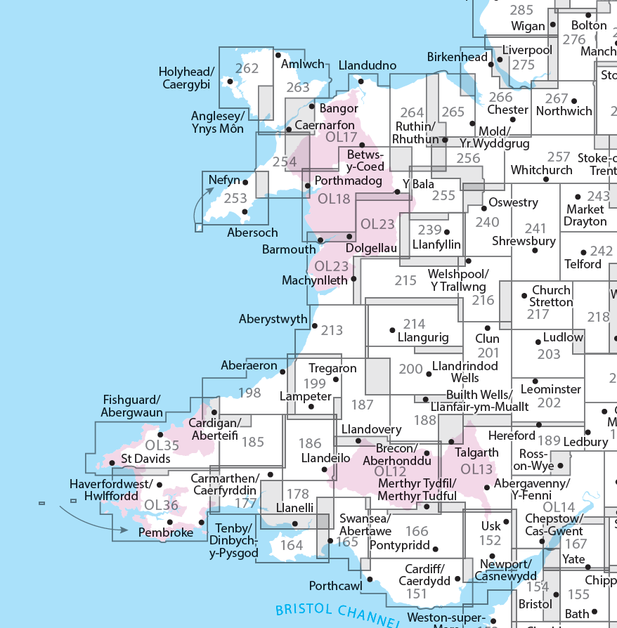
Locatie op kaart
Overzichtskaarten

OSI Explorer & Explorer Active - Wales
OSI Explorer & Explorer Active - Wales

Producten op de overzichtskaart
Klik op een product om naar de detailpagina te gaan.
- Wandelkaart 151 Cardiff & Bridgend- Wales - OSI
- Wandelkaart 152 Newport & Pontypool- South Wales - OSI
- Wandelkaart 164 Gower AONB & Gwyr- South Wales - OSI
- Wandelkaart 165 Swansea & Abertawe- South Wales - OSI
- Wandelkaart 166 Rhondda & Merthyr Tydfil - OSI
- Wandelkaart 177 Carmarthen & Kidwelly- Wales - OSI
- Wandelkaart 178 Llanelli- Ammanford & Rhydaman - OSI
- Wandelkaart 185 Newcastle & Emly- Northumberland - OSI
- Wandelkaart 186 Llandeilo- Brechfa Forest- Wales - OSI
- Wandelkaart 187 Llandovery- South Wales - OSI
- Wandelkaart 188 Builth Wells & Llanfair-ym-Muallt - OSI
- Wandelkaart 189 Hereford & Ross-on-Wye- England - OSI
- Wandelkaart 198 Cardigan & New Quay- Wales - OSI
- Wandelkaart 199 Lampeter- Wales - OSI
- Wandelkaart 200 Llandrindod Wells & Elan Valley - OSI
- Wandelkaart 201 Knighton & Presteigne- Wales - OSI
- Wandelkaart 202 Leominster & Bromyard Hererfordshire - OSI
- Wandelkaart 203 Ludlow & Shropshire Hills AONB - OSI
- Wandelkaart 213 Aberystwyth & Cwm Rheidol - Wales - OSI
- Wandelkaart 214 Llanidloes- Newtown & Y Drenewydd - OSI
- Wandelkaart 215 Newtown & Machynlleth- Powys Wales - OSI
- Wandelkaart 216 Welshpool & Montgomery- Powys - OSI
- Wandelkaart 217 Long Mynd & Wenlock Edge - OSI
- Wandelkaart 239 Lake Vyrnwy & Efyrnwy- North Wales - OSI
- Wandelkaart 240 Oswestry & Croesoswallt- Shropshir - OSI
- Wandelkaart 241 Shrewsbury- shropshire England - OSI
- Wandelkaart 253 Lleyn Peninsula West Wales - OSI
- Wandelkaart 254 Lleyn Peninsula East- Wales - OSI
- Wandelkaart 255 Llangollen & Berwyn- West Wales - OSI
- Wandelkaart 256 Wrexham- Wrecsam & Llangollen - OSI
- Wandelkaart 257 Crewe & Nantwich & Cheshire East - OSI
- Wandelkaart 262 Anglesey West- Wales AONB - OSI
- Wandelkaart 263 Anglesey East AONB- Wales - OSI
- Wandelkaart 264 Vale of Clwyd & Dyffryn Clwyd - OSI
- Wandelkaart 265 Clwydian Range & Bryniau Clwyd - OSI
- Wandelkaart 266 Wirral- Chester & Caer- Merseyside - OSI
- Wandelkaart 267 Northwich & Delamere Forest - OSI
- Wandelkaart 275 Liverpool- South West England - OSI
- Wandelkaart OL012 Brecon Beacons Nat. Parc West & Central areas
- Wandelkaart OL013 Brecon Beacons National Parc East - OS
- Wandelkaart OL035 Pembrokeshire National Park North - OS
- Wandelkaart OL036 Pembrokeshire National Park South - OS
- Wandelkaart OL017 Snowdon- Conwy Valley & Dyffryn Conwy - OS
- Wandelkaart OL018 Harlech- Porthmadog & Y Bala - OS
- Wandelkaart OL023 Cadair Idris & Llyn Tegid - OS
Artikelen uit dezelfde regio
Wandelkaart XT25 Brecon Beacons Oost - Harvey Maps • 9781851376711
Wandelkaart Brecon Beacons Oost - Harvey Maps Productomschrijving: Gedetailleerde kaart voor bergwandelaars van het oostelijke deel van het Brecon Beacons National Park. Inclusief de Pen y Fan en de Black Mountains. - De kaart is sterk, licht, duurzaam en 100% waterbestendig - Inclusief opengestelde wegen - Opent direct aan beide zijden van het blad - Eenvoudig opnieuw te vou…

Wandelkaart 145 Cardigan & Mynydd Preseli - OSI • 9780319262436
Wandelkaart Cardigan & Mynydd Preseli - OSI Pembrokeshire Coast National Park Productbeschrijving: Het gebied van Zuid-West Wales gedekt door OS Landranger kaart 145 heeft veel te bieden. Volg de schilderachtige Pembrokeshire Coast Path door het Pembrokeshire Coast National Park naar de stad van Cardigan, waar u een boottocht kunt maken om dolfijnen in de baai van Cardigan te zien. …

Landkaart Wegenkaart 7 Zuidwest Engeland & Zuid Wales - OSI • 9780319263792
Wegenkaart Zuidwest Engeland & Zuid Wales - OSI Productomschrijving: Plan your journey with this series of road maps from OS. Showing all major road, rail and ferry links as well as settlements and selected features in 1: 250 000 scale, this is the ideal map for planning trips and holidays by car or cycle. OS Road 7 covers: the south-west England plus south Wales, Devon & Cornwall. …
Wandelgids Day Walks in the Brecon Beacons - Vertebrate Publ. • 9781906148621
Day Walks in the Brecon Beacons - Vertebrate Productomschrijving: Day Walks in the Brecon Beacons features 20 circular routes between 6.8 and 16.5 miles (11km and 16.6km) in length. Author Harri Roberts shares his favourite walks in the region, including Llangors Lake, the Taf Fechan Skyline and the Llanbedr Horseshoe. Each route features Ordnance Survey maps, easy-to-follow directions an…
Wandelkaart OL13 Brecon Beacons NP - Eastern area - OSI • 9780319469316
Wandelkaart Brecon Beacons NP - Eastern area South Wales Omvat het oostelijke deel! Productbeschrijving: Van Blaina in het zuiden bij hay-on-Wye in het noorden, betreft dit gebied de Black Mountains en deel van een aantal bekende nationale routes en recreatieve paden zoals, de Beacons way, Herefordshire Trail, Offa's Dyke Path & Taff Trail. De Brecon Beacons biedt een breed scala aan b…


