

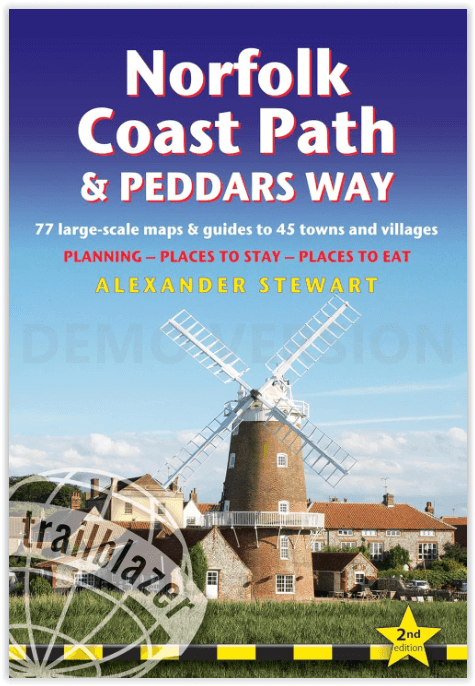
Wandelgids Norfolk Coast Path & Peddars Way - Trailblazer
Knettishall Heath - Holme-next-the-Sea - Holkham - Wells
Korte omschrijving
Wandelgidsen Norfolk East England en Suffolk East Anglia van Trailblazer Publications. Ideaal voor tochten in England.
Norfolk Coast Path & Peddars Way - Trailblazer Productomschrijving: De Peddars Way loopt door East Anglia vanaf Knettishall Heath op de grens van Norfolk en Suffolk en volgt een Romeinse weg...

Specificaties
- Uitgever: Trailblazer Publications
- ISBN-13: 9781912716395
- HOOFDCATEGORIEËN: Wandelgids
- Activiteiten: Wandelen, Hiking & Trekking
- Auteur: Alexander Stewart
- Regio: Norfolk East England, Suffolk East Anglia
- Land: England
- Lange afstand wandelroutes: Peddars Way & Norfolk Coast Path (135 km)
- AONB - Area of Outstanding Beauty/National Landscape: Norfolk Coast AONB
- Editie: 2
- Taal: Engels
- De Engelse Graafschappen: Norfolk
- National Trails UK, England & Wales: Norfolk Coast Path, England
Volledige omschrijving
Norfolk Coast Path & Peddars Way - Trailblazer
Productomschrijving: De Peddars Way loopt door East Anglia vanaf Knettishall Heath op de grens van Norfolk en Suffolk en volgt een Romeinse weg naar Holme-next-the-Sea. Van hieruit wordt het het Norfolk Coast Path, dat de prachtige kustlijn van Norfolk volgt via Holkham, Wells, Blakeney en Cley naar Cromer voordat het de schouder van het graafschap rondt en verder gaat langs de prachtige stranden en afbrokkelende kliffen naar Mundesley, Sea Palling en Great Yarmouth, om te eindigen net voor de grens met Suffolk. Deze gids omvat 130 mijl wandelen en de verlenging van het National Trail van Cromer naar Hopton-on-Sea van 40 mijl.
77 trail maps and 8 town plans
10 stage maps with profiles and 2 overview maps
60 colour photos; colour flower guide
The Peddars Way runs through East Anglia from Knettishall Heath on the Norfolk/Suffolk border and follows a Roman road to Holme-next-the-Sea. From here it becomes the Norfolk Coast Path, hugging the beautiful Norfolk coastline through Holkham, Wells, Blakeney and Cley to Cromer before it rounds the shoulder of the county and continues along the superb beaches and crumbling cliffs to Mundesley, Sea Palling and Great Yarmouth, finishing just before the Suffolk border. Covering 130 miles of walking, this guide includes the 40-mile extension of the National Trail from Cromer to Hopton-on-Sea.
- Text & maps in clear two-colour style
- GPS waypoints with what3words refs
- All-in-one guide
– Trailblazer guides include practical information not usually found in walking guides to the UK: reviews of places to stay, places to eat, attractions along the way and detailed public transport information showing all access points on the path and car parks near the trail, for weekend and day walkers.
- The largest scale walking maps available – At just under 1:20,000 (8cm or 31/8 inches to 1 mile) our maps (fully-edited and drawn by walkers for walkers) are bigger than even the most detailed walking maps currently available in the shops.
Locatie op kaart
Artikelen uit dezelfde regio

Wandelgids Day Walks in East Anglia - Vertebrate Publ. • 9781839810114
Day Walks in East Anglia - Vertebrate Productomschrijving: Day Walks in East Anglia by Anna Paxton features 20 routes in Norfolk and Suffolk suitable for hillwalkers of all abilities. Together with stunning photography, each route features Ordnance Survey 1:25,000 maps, easy-to-follow directions, distance and navigation information, refreshment stops and local information. Researched a…

Fietskaart 14 Suffolk cycling map - Goldeneye • 9781859653050
Fietskaart Suffolk cycling map - Goldeneye Productomschrijving: Kleine dorpen, prachtige landschappen, met grintwegen, en verkeersvrije wegen, dit is er ene voor de enthousisaste fietsers die van de natuur houden. Engelse omschrijving: Suffolk must surely be one of the most charming counties to explore by bicycle. When Al Churcher delivered his routes to us we couldn’t keep him quiet …

Wandelkaart 211 Bury St Edmunds & Stowmarket - OSI • 9780319470831
Wandelkaart Bury St Edmunds & Stowmarket - Suffolk Omvat ook: Debenham & Elmswell. Productbeschrijving: Deze twee-zijdige kaart toont Bury St Edmunds tot Debenham, met inbegrip van Stowmarket. Er zijn een aantal recreatieve paden met inbegrip van St Edmund's way die hier voorbijlopen, de Adelborst Railway trail en deel van de Mid Suffolk trail. Er zijn ook vele kleine steden en dorpen …
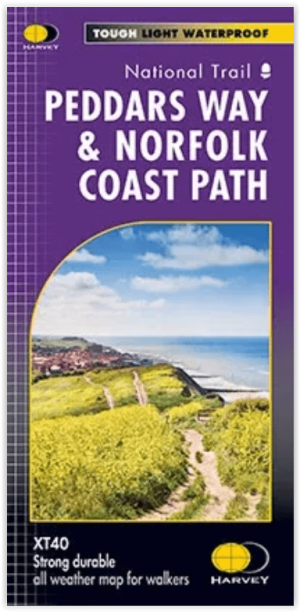
Wandelgids Peddars Way & Norfolk Coast Path XT40 - Harvey Maps • 9781851376292
Wandelgids Peddars Way & Norfolk Coast Path XT40 - Harvey Maps Productomschrijving: Peddars Way is een langeafstand wandelroute van 74 km langs de Norfolk kust. De Norfolk coastal path, sluit daar direct op aan verder, en samen zijn ze deen dikke 215 km lang. Een prachtige route die onstaan is al in de Romeinse tijd. Samen lopen de routes van Hunstanton tot Hopton-on-Sea. De gids omvat ac…

Wandelkaart 238 East Dereham & Aylsham- Norfolk - OSI • 9780319471104
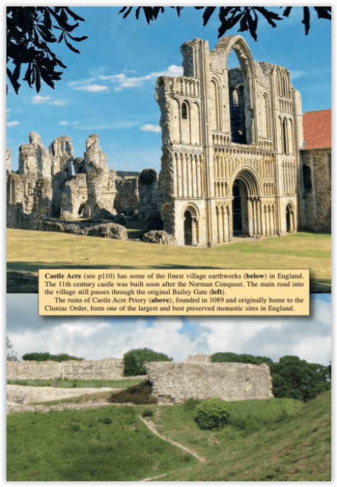
Wandelkaart East Dereham & Aylsham - Norfolk England Omvat ook: Castle Acre & Reepham. Productbeschrijving: Kaart nummer 238 omvat Dereham en Aylsham. Hoogtepunten zijn onder andere kasteel Acre en Durham. Omvat ook Beetley, Taverham, grote Ryburgh, Lenwade en rivier Wensum. De OS Explorer kaart voor Dereham & Aylsham is beschikbaar in zowel de standaard papieren versie als de weerbest…