
Activiteiten
Land
Regio
Editie
Taal
Schaal
Auteur:
Lange afstand wandelroutes
Historische wandelroutes
Waterafstotende kaart
Nationale parken
Regionale parken
VTT / MTB
Toepasselijke bergketen
UNESCO werelderfgoed
TOPO's & Stafkaarten
Uitgever


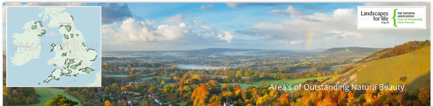
 Area's of Outstanding Natural Beauty
Areas of Outstanding Natural Beauty (AONB's) in het Verenigd Koninkrijk zijn regio's die bekend staan om hun uitzonderlijke landschappen, die een toevluchtsoord zijn voor de natuur en een toevluchtsoord voor bezoekers die op zoek zijn naar natuurschoon en rust. Deze gebieden worden beschermd om hun natuurlijke charme, culturele erfgoed en biodiversiteit te behouden.
Het Verenigd Koninkrijk telt 46 AONB's, elk met een uniek karakter. De Cotswolds, met zijn heuvels en pittoreske dorpjes, is een van de grootste en bekendste en biedt een typisch Engels landschap. Het Lake District NP, hoewel in de eerste plaats een nationaal park, overlapt met AONB's zoals Arnside en Silverdale, bekend om zijn kalkstenen trottoirs en rijke vogelleven. In het zuiden biedt de Surrey Hills AONB eeuwenoude bossen en krijtrotsen, terwijl de South Downs AONB, nu onderdeel van het South Downs National Park, bekend staat om zijn weidse uitzichten en historische locaties. De Wye Valley, op de grens tussen Engeland en Wales, staat bekend om zijn dramatische rivierlandschappen en dichte bossen.
Verder weg vindt u in het Northumberland Coast AONB ruige kliffen, zandstranden en historische kastelen, terwijl de Mourne Mountains in Noord-Ierland een verbluffende mix bieden van ruige bergtoppen en serene valleien. Elke AONB biedt een uniek stukje natuurschoon van het Verenigd Koninkrijk, voor elke natuurliefhebber wat wils. Een deel van de AONB regio's klaseren zelfs tegelijk als UNESCO Werelderfgoed.

Wandelkaart XT25 Forest of Bowland Lancashire England - Harvey • 9781851377206
Wandelkaart Forest of Bowland Lancashire - Harvey Maps Productomschrijving: Meer dan een kaart - een essentieel deel van je uitrusting. Deze nieuwe generatie HARVEY Superwalker kaarten is ontworpen om de meest praktische outdoor navigatietool te zijn. - De ideale kaart om het Forest of Bowland National Landscape te verkennen - Omvat Settle, Gisburn Forest en de Trough of Bowland - …

Cotswolds Mountain Biking - Vertebrate Publ. • 9781906148140
Cotswolds AONB Mountain Biking - Vertebrate Productomschrijving: 20 Classic Rides - Cotwolds Mountain Biking by Tom Fenton features 20 classic MTB routes in the Cotswold Hills across the counties of Gloucestershire and Oxfordshire, and extending into parts of Wiltshire, Somerset, Worcestershire and Warwickshire. With Ordnance Survey mapping and easy-to-follow directions. The Cotswold H…

Fietsgids Pennine Bridleway Cycling guide - Vertebrate Publ. • 9781839810428
Pennine Bridleway Cycling guide - Vertebrate Productomschrijving: From Derbyshire through the Yorkshire Dales to Cumbria Pennine Bridleway by Hannah Collingridge is a guidebook to this National Trail taking you from Derbyshire through the Yorkshire Dales to Cumbria, following the Pennine Hills AONB. Together with stunning photography, the route features Ordnance Survey 1:50,000 maps, e…
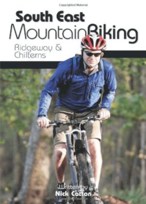
Fietsgids South East Mountain Biking - Vertebrate Publ. • 9781906148058
South East Mountain Biking - Vertebrate Productomschrijving: South East Mountain Biking Ridgeway & Chilterns (Hills AONB) is a compact guide to some of the best mountain bike riding in Southern England, west of London. This guide contains 24 routes from 18 to 38 kilometres long. Each is described with easy-to-follow directions and details of distance, grade of difficulty, refreshment stops…

Fietsgids South West Mountain Biking - Vertebrate Publ. • 9781906148263
South West Mountain Biking - Vertebrate Productomschrijving: A guide to the mountain biking in the south west of England. It features 26 of the best mountain bike rides in Dartmoor, Exmoor and the Quantock Hills, between 10km and 30km in length, suitable for different levels of mountain bikers. It also features industry-standard Ordnance Survey mapping. South West Mountain Biking – Qu…

Fietsgids Wales Mountain Biking - Vertebrate Publ. • 9781906148133
Wales Mountain Biking - Vertebrate Productomschrijving: Wales Mountain Biking – Beicio Mynydd Cymru by Tom Hutton showcases 20 of the best mountain bike rides in Wales, between 12km and 50km in length, suitable for all levels of mountain bikers. It features three sections: South Wales, Mid Wales and North Wales. Each route is described with easy-to-follow directions and includes OS 1:50,00…

Wandelgids Sussex Walks - Vertebrate Publ. • 9781906148683
Wandelgids Sussex Walks - Vertebrate Productomschrijving: 20 walks exploring the Weald and the South Downs Natioal Park. Sussex Walks is a collection of 20 circular walks, between 3.5 and 12 miles (5km and 19km) in length that explore the length and breadth of the county of Sussex. Written by local author Deirdre Huston, the walks feature Ordnance Survey 1:25,000 maps, easy-to-follow …
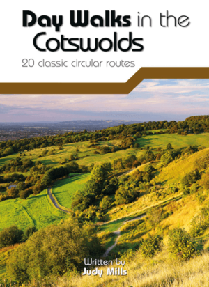
Wandelgids Day Walks in the Cotswolds AONB - Vertebrate Publ. • 9781910240991
Day Walks in the Cotswolds AONB - Vertebrate Productomschrijving: Day Walks in the Cotswolds by Judy Mills features 20 circular routes suitable for hillwalkers of all abilities. Together with stunning photography, each route features Ordnance Survey 1:25,000 maps, easy-to-follow directions, distance and navigation information, refreshment stops and local information. Split across thre…

Wandelgids Day Walks in East Anglia - Vertebrate Publ. • 9781839810114
Day Walks in East Anglia - Vertebrate Productomschrijving: Day Walks in East Anglia by Anna Paxton features 20 routes in Norfolk and Suffolk suitable for hillwalkers of all abilities. Together with stunning photography, each route features Ordnance Survey 1:25,000 maps, easy-to-follow directions, distance and navigation information, refreshment stops and local information. Researched a…
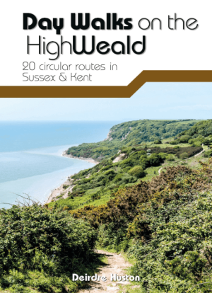
Wandelgids Day Walks on the High Weald AONB - Vertebrate Publ. • 9781911342854
Day Walks on the High Weald AONB - Vertebrate Productomschrijving: 20 circular routes in Sussex & Kent Day Walks on the High Weald features 20 circular routes between 6.5 and 13.9 miles (10.5km and 22.4km) in length, spread across this AONB- Area of Outstanding Natural Beauty in the south-east of England. Local author Deirdre Huston has compiled her favourite walks in the region, whic…

Wandelgids Cotswolds - Heart of the Cotswolds - Rucksack Readers • 9781913817268
Wandelgids Cotswolds - Heart of the Cotswolds - Rucksack Productomschrijving: The Cotswolds AONB is quintessentially English, with its rich cultural history, medieval ‘wool’ churches and charming domestic architecture of stone, slate and thatch. The book offers three options for walking in the heart of this wonderful area: a 94-mile (151-km) grand tour starting from Cheltenham, and two sh…

Landkaart Wegenkaart Planning map Oxford & The Cotswolds • 9781788688499
Wegenkaart Planning map Oxford & The Cotswolds Productomschrijving: From Lonely Planet, the world's leading travel guide publisher Durable and waterproof, with a handy slipcase and an easy-fold format, Lonely Planet's Oxford & the Cotswolds Planning Map helps you get around with ease. Get more from your map and your trip with images and information about top attractions. - Durable and …

Wandelgids Gower walking South Wales - Cicerone • 9781786312846
Wandelgids Gower walking - Cicerone Productomschrijving: The 30 circular routes in this guide to walking on the Gower peninsula, an Area of Outstanding Natural Beauty in South Wales, cover the rugged coastline, beaches and inland valleys and ridges. The walks visit a variety of landscapes and range from 2½ to 14 miles long. Packed with historical and geological information. Seasons: …
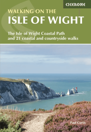
Wandelgids Isle of Wight walking guide - Cicerone • 9781786312563
Wandelgids Isle of Wight - Cicerone Productomschrijving: Guidebook to 33 walking routes on the beautiful Isle of Wight, from 4 to 18 miles long. The routes are suitable for all abilities and are accessible all year round. Includes a complete circuit of the island's spectacular coast as well as walks exploring forest trails and downland, and visiting the towns of Yarmouth, Cowes and Ventnor…

Wandelkaart XT25 Cannock Chase AONB - Harvey Maps • 9781851377244
Wandelkaart Cannock Chase AONB - Harvey Maps Productomschrijving: Toont het hele gebied van Cannock Chase National Landscape AONB Uitgegeven in samenwerking met de National Navigation Award Scheme en Cannock Chase National Landscape. - De kaart is sterk, licht, duurzaam en 100% waterbestendig - Inclusief opengestelde wegen - Ontdaan van irrelevante informatie voor de wandelaar…

Wandelkaart OL08 Chichester- South Harting & Selsey - OS • 9780319242476
Wandelkaart Chichester- South Harting & Selsey - OS Productomschrijving: The South Downs National Park, West Sussex England, Chichester- South Harting & Selsey. Omvat: Emsworth, Havant, Horndean, Midhurst and Wittering. Highlights of the area include: Hayling Island, Selsey Bill, Chichester Harbour, Sussex Downs, East Hampshire, and South Downs Way National trail! Ontdek de OL-seri…
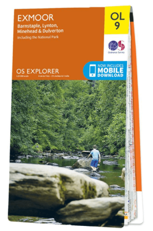
Wandelkaart OL09 Exmoor NP Devon England - OS • 9780319242483
Wandelkaart Exmoor NP Devon England - OS Productomschrijving: Exmoor National Park, Devon England Omvat: Exmoor National Park, Devon England, Barnstaple, Lynton, Minehead & Dulverton. Ontdek de OL-serie van Ordnance Survey: De OL-serie (Outdoor Leisure) van Ordnance Survey is dé referentie voor wie gaat wandelen op de Britse eilanden. Deze topografische kaarten maken deel uit va…

Wandelkaart OL15 Purbeck & South Dorset - OS • 9780319242544
Wandelkaart Purbeck & South Dorset - OS Productomschrijving: Parts of the South West Coast Path SWCP, Dorset Area of Outstanding Natural Beauty. Omvat: Purbeck, South Dorset, Poole, Dorchester, Weymouth & Swanage, Castleman Trailway, E9 European Coastal parth, England Coast Path, Hardy Way, Jubilee Trail, Macmillan Way, Monarch's Way, Poole Harbour Trail, Portland Coast Path, Purbeck …
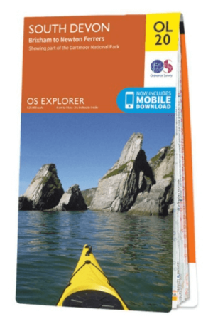
Wandelkaart OL20 South Devon & Dartmoor NP - OS • 9780319242599
Wandelkaart South Devon - OS Productomschrijving: South Devon, Dartmoor National Park and parts of the South West Coast Path SWCP, South Devon AONB and Tamar Valley AONB. Omvat: Brixham to Newton Ferrers, Avon Estuary Walk, Co-operative Way, Dart Valley Trail, E9 European Long Distanse Path, Erme-Plym Trail, Greenway Walk, John Musgrave Heritage Trail, Plymouth Cross-City Link, South …
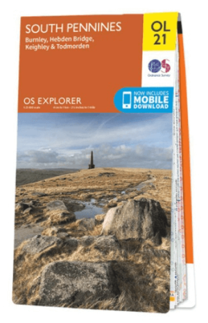
Wandelkaart OL21 South Pennines - OS • 9780319242605
Wandelkaart South Pennines - Ordnance Survey Productomschrijving: Parts of the Peak District National Park, South Pennines, Brontë Way, Burnley Way, Calder / Aire Link, Calderdale Way, Colne Valley Circular Walk, Dales High Way, E2 European long distance Path, Irwell Sculpture trail, Kirklees Way, Meltham Way, Millenium Way, Oldhan Way & Crompton Circuit, Pendle Way, Pennine Bridleway, Pen…
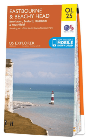
Wandelkaart OL25 Eastbourne & Beachy Head - OS • 9780319242643
Wandelkaart Eastbourne & Beachy Head - OS Productomschrijving: Eastbourne & Beachy Head Omvat: Newhaven, Seaford, Hailsham & Heathfield, Uckfield, the High Weald AONB, South Downs National Park, South Downs Way, Cuckmere Haven, River Cucksmereand the 1066 Country Walk. Ontdek de OL-serie van Ordnance Survey: De OL-serie (Outdoor Leisure) van Ordnance Survey is dé referentie voor …
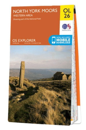
Wandelkaart OL26 North York Moors Western area - OS • 9780319242650
Wandelkaart North York Moors, Western area - OS Productomschrijving: Een topografische wandelkaart van het westerse deel van het North York Moors National Park. Omvat: Het Howardian Hills AONB gebied, deel van het nationale park van de North York Moors, Tees Forest Community Forest, The Cleveland Street Walk, Cleveland Way, E2 European long distance Path, Ebor Way, England Coast PAth, …

Wandelkaart OL31 Northern Pennines AONB, Teesdale & Weardale - OS • 9780319242704
Wandelkaart Northern Pennines, Teesdale & Weardale - OS Productomschrijving: Northern Pennines AONB, Teesdale & Weardale, part of the Pennine Way, Omvat: A pennine Journey, E2 European Long Distance Path, Isaac's Tea Trail, Pennine Way, South Tyne Trail, Tees Railway Path, Teesdale Way & Weardale Way. Ontdek de OL-serie van Ordnance Survey: De OL-serie (Outdoor Leisure) van Ordn…

Wandelkaart OL33 Haslemere & Petersfield - OS • 9780319242728
Wandelkaart Haslemere & Petersfield - OS Productomschrijving: Haslemere, Petersfield, Midhurt & Selborne. Omvat: Haslemere, Petersfield, Midhurst and Selborne, South Downs National Park, Surrey Hills and the Sussex Border Path, Greensand Way, Hangers Way, the River Rother and New Lipchis Way Ontdek de OL-serie van Ordnance Survey: De OL-serie (Outdoor Leisure) van Ordnance Surve…

Wandelkaart OL33 Haslemere & Petersfield - OS • 9780319242735
Wandelkaart Crawley & Horsham - Ordnance Survey Productomschrijving: Crawley, Horsham, Cranleigh, Billinghurst & part of the South Downs National Park. Omvat: Crawley, Horsham, Cranleigh, Billinghurst, The AONB regions of the Surrey Hills and High Weald, part of the South Downs National Park, Downs Link, Greensand Way, High Weald Landscape Trail, Serpent Trail, Sussex Border Path, Sus…
Gebieden van uitmuntend natuurschoon
Gebieden van uitmuntend natuurschoon, of AONB of Area’s of Outstanding Natural Beauty, is een sublieme collectie aan natuur schoon, die alles samen bracht in een speciale verdrag beschreven in de “National Parks and Access tot he Countryside Act 1949”. In Schotland daarentegen noemen ze dezelfde regio’s “National Scenic Area’s”. Ongeveer 18% van het land is gedekt met deze AONB regio’s, onlangs kwamen er nog enkele bij zoals Erne Lakeland, Fermanagh en Caveland. Het grootste gebied zijn de Cotswolds met zo’n 2038 km² Km. Dat zich uitstrekt in ondermeer West Oxfordshire & Gloucestershire. De kleinste, The isles of Scilly , is maar 16 km².
De AONB organisatie, en bijgevolg ook zijn eerste AONB regio vieren algauw hun 50e verjaardag. Gowers Golden anniversary, word aanschouwd als een goede reden om de aanvang van de organisatie te vieren, die nu zo’n 46 regio’s dekt over 4 delen van Groot Brittannië. AONB’s als de Cannock Chase, de Chilterns, Cornwall & de Cotswolds, zijn tot ver buiten hun grenzen gekend voor zijn prachtige natuurgebieden, en zijn dan ook een jaarlijkse trekpleister voor natuurfanaten, en fans van wandelingen door speciale gebieden. In het westen van Engeland bevinden zich de meeste van de AONB’s, de kans bestaat dat u bij uw aanwezigheid in Engeland, reeds door zo’n gebied bent gereden zonder te weten.
Wandelen in een AONB gebied
Wandelen in de Britse AONB gebied, is een reis door enkele van de meest adembenemende landschappen van de UK. Deze beschermde gebieden bieden diverse paden die geschikt zijn voor wandelaars van elk niveau, van rustige wandelingen tot uitdagende tochten, allemaal tegen een adembenemend decor. De Chiltern Hills AONB, op korte afstand van Londen, biedt een mix van glooiende heuvels, beukenbossen en historische dorpjes. Paden zoals het Ridgeway National Trail bieden panoramische uitzichten en een gevoel alsof je terug in de tijd stapt, met oude paden en prehistorische vindplaatsen langs de route. Sommige van deze trails ijzn zelfs geklasseerd als Hystorische fiets- en wandelpaden.
In de Cotswolds, een van de grootste AONB's, kunnen wandelaars een typisch Engels landschap verkennen met heuvels, honingkleurige stenen dorpjes en meanderende rivieren. De Cotswold Way, een langeafstandspad, biedt een reis door dit schilderachtige gebied, met mogelijkheden om historische monumenten en charmante stadjes te ontdekken. De North Pennines AONB, bekend als de laatste wildernis van Engeland, biedt ruiger terrein met heidevelden, watervallen en zeldzame wilde dieren. De High Force waterval en het weidse uitzicht vanaf Cross Fell zijn hoogtepunten voor avontuurlijke wandelaars.
Of het nu de dramatische kliffen van de Cornwall AONB zijn, de serene schoonheid van de Wye Valley of de weidse landschappen van de Yorkshire Dales NP, wandelen in een AONB dompelt je onder in de meest waardevolle natuurlijke omgevingen van het Verenigd Koninkrijk.
Waar vindt men de AONB gedieden
Waar vindt men de AONB gedieden? Uiteraard zijn AONB's verspeidt over gans Groot Brittannië, we sommen die op per regio:
Engeland: Arnside and Silverdale, Blackdown Hills, Cannock Chase, Chichester Harbour, Chilterns, Cornwall, Cotswolds, Cranborne Chase and West Wiltshire Downs, Dedham Vale, Dorset, East Devon, East Hampshire, Forest of Bowland, High Weald, Howardian Hills, Isle of Wight, Isles of Scilly, Kent Downs, Lincolnshire Wolds, Malvern Hills, Mendip Hills, Nidderdale, Norfolk Coast, North Devon Coast, North Pennines, Northumberland Coast, North Wessex Downs, Quantock Hills, Shropshire Hills, Solway Coast, South Devon, South Hampshire Coast, Suffolk Coast and Heaths, Surrey Hills, Sussex Downs, Tamar Valley.
Wales: Anglesey, Clwydian Range, Gower, Lleyn, Wye Valley.
Noord Ierland: Antrim Coast en Glens, Causeway Coast, Lagan Valley, Lecale Coast, Mourne Mountains, North Derry, Ring of Gullion, Sperrins & Strangford Lough.
Dit zijn de 50 Area's of Outstanding Natural beauty.