

Wandelkaart 245 Black Canyon of the Gunnison NP - Natgeo
Een nationaal park in het westen van het Amerikaanse Colorado

Korte omschrijving
Wandelkaarten Colorado, USA van National Geographic. Ideaal voor tochten in Verenigde Staten van Amerika (USA).
TOPO Wandelkaart 245 - Black Canyon of the Gunnison NP - Nat Geo Productomschrijving: Het Black Canyon of the Gunnison National Park is een nationaal park in het westen van de Amerikaanse s...

Specificaties
- Uitgever: National Geographic
- ISBN-13: 9781566953689
- HOOFDCATEGORIEËN: Wandelkaart
- Activiteiten: Wandelen, Hiking & Trekking
- Auteur: National Geographic
- Regio: Colorado, USA
- Land: Verenigde Staten van Amerika (USA)
- Nationale parken: Black Canyon of the Gunnison NP, Colorado USA
- TOPO's & Stafkaarten: Topografisch wandelen
- Schaal: 1:63360
- Taal: Engels
Volledige omschrijving
TOPO Wandelkaart 245 - Black Canyon of the Gunnison NP - Nat Geo
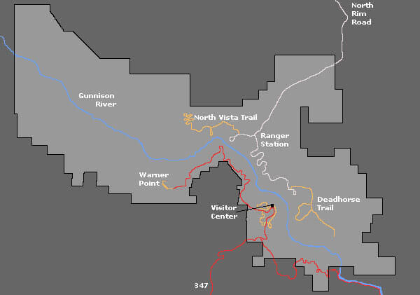
Productomschrijving: Het Black Canyon of the Gunnison National Park is een nationaal park in het westen van de Amerikaanse staat Colorado. Het beschermt 19 km van de 77 km lange kloof van de Gunnison River, een zijrivier van de Colorado River.
Engelse omschrijving: The Black Canyon, 48 miles of awe-inspiring, steep-walled canyon carved by the Gunnison River, has been an obstacle and attraction to residents and visitors alike for centuries. National Geographic's Trails Illustrated map of Black Canyon of the Gunnison National Park and Curecanti National Recreation Area delivers unmatched detail and valuable information to assist you in your exploration of this breathtaking wilderness. Expertly researched and created in partnership with local land management agencies, this map includes Gunnison Gorge National Conservation Area; Blue Mesa Reservoir; portions of Gunnison National Forest and West Elk Wilderness; and the towns of Montrose, Paonia, and Hotchkiss.
Designed with a wide range of visitors in mind, this map features detailed and easy-to-read trails, accurate road network, and a variety of information about the region and recreational activities available, including hiking trail summaries for the north and south rims of the canyon. Trail use is easy to identify, whether you're traveling on foot, horse, OHV, or snowmobile. Road types are differentiated as well, so you know if the route you choose is a four-wheel-drive or high-clearance road. The West Elk Loop and Silver Thread scenic byways are noted for those wishing to take in the scenery by car. Campgrounds, fishing areas, boat ramps, river access, and primitive campsites for hikers and boaters throughout the park are shown, as well as rapids and ratings along the Gunnison River. The map base includes contour lines and elevations for summits, passes and many lakes.
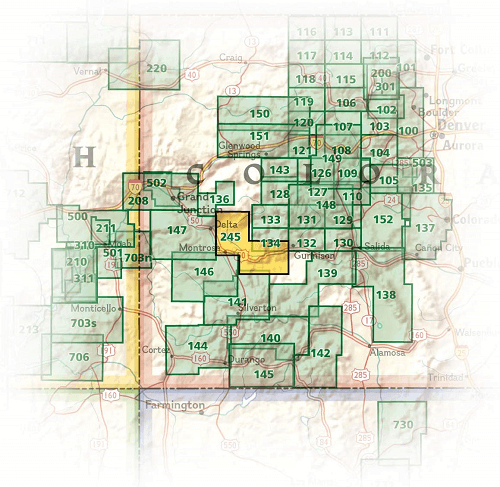
Locatie op kaart
Overzichtskaarten
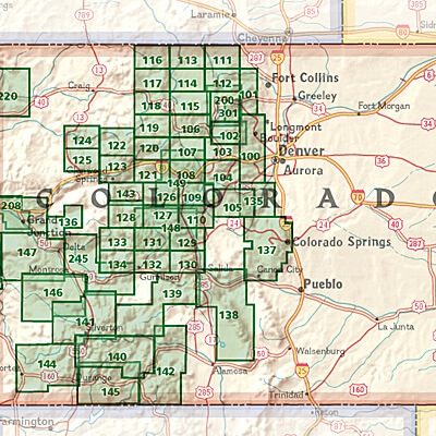
NAT GEO Colorado trail maps
NAT GEO Colorado trail maps
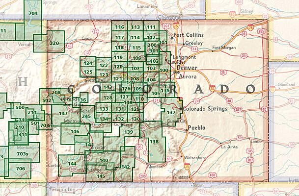
Producten op de overzichtskaart
Klik op een product om naar de detailpagina te gaan.
- Wandelkaart 110 Leadville & Fairplay - Colorado - Nat Geo
- Wandelkaart 127 Aspen - Independence Pass - Colorado USA
- Wandelkaart 137 Pikes Peak & Cañon City - Nat Geo
- Wandelkaart 138 Sangre de Cristo Mountains - Nat Geo
- Wandelkaart 139 La Garita Caldera - Cochetopa - Nat Geo
- Wandelkaart 140 Weminuche Wilderness Colorado USA - Nat Geo
- Wandelkaart 141 Telluride- Silverton- Ouray & Lake City - Nat Geo
- Wandelkaart 144 Durango & Cortez- Colorado - Natgeo
- Wandelkaart 208 Colorado National Monument - Natgeo
- Wandelkaart 245 Black Canyon of the Gunnison NP - Natgeo
Artikelen uit dezelfde regio

Wandelkaart 220 Dinosaur National Monument - Natgeo • 9781566954037
TOPO Wandelkaart 220 - Dinosaur National Monument - Nat Geo Productomschrijving: Dinosaur National Monument in de United States, gelegen op de zuidoostelijke kant van de Uinta Mountains op de grens tussen Colorado en Utah met invloeden van de Green & Yampa Rivieren. Ondanks dat het grootste deel ervan gelegen is in Moffat County, Colorado, is Dinosaur gelegen in Utah net ten noorden van de…

Landkaart Wegenkaart Colorado State guide map - Nat Geo • 9781566957779
Wegenkaart Colorado State guide map - Nat Geo Productomschrijving: National Geographic's Colorado Guide Map is designed to meet the needs of travelers with detailed and accurate cartography and loads of helpful information about the state's many attractions. Cities and towns are easy to find with the map's helpful index. Highways, roadways, toll roads, scenic routes, and other roads are cl…

Wandelkaart 119 Yampa & Gore Pass Colorado USA - Nat Geo • 9781566953931
Yampa & Gore Pass Colorado USA - Nat Geo Productomschrijving: Outdoor enthousiastelingen die het hele jaar door willen genieten van de recreatieve mogelijkheden in en rond het zuiden van Routt National Forest zullen zich verbazen over National Geographic's Trails Illustrated kaart van Yampa en Gore Pass. Gemaakt in samenwerking met de U.S. Forest Service, Bureau of Land Management en ander…

Wandelkaart 1202 Colorado Trail Noord - Nat geo • 9781566956956
TOPO Wandelkaart 1202 - Colorado Trail Noord - Natgeo Productomschrijving: The Colorado Trail is een lange-afstands wandelroute van om en bij de 782 km. Deze loopt van de mond van Waterton Canyon ten zuidwesten van Denver tot Durango in Colorado. Zijn hoogste punt is 4,045 meter boven zeeniveau, en de overgrote meerderheid van de route loopt boven de 3,000 meter. Ondanks zijn hoog gelegen …

Wandelkaart 1303 Colorado 14ers- Zuid - Nat geo • 9781566957007
TOPO Wandelkaart 1303 - Colorado 14ers- Zuid - Natgeo Productomschrijving: De colorad 14'ers Zuid, zijn de 14 meest indrukwekkende bergmassieven in het zuiden van Colorado. De locatie is onderverdeeld in drie regio's zoals: De Elk Range, San Juan Range & Sangre De Cristo Range. Elk Range: Capitol Peak, Castle Peak, Conundrum Peak, Maroon Peak, North Maroon Peak, Pyramid Peak, Snowmass …