

Wandelkaart 127 Aspen - Independence Pass - Colorado USA
Hunter Pass- is a high mountain pass in central Colorado

Korte omschrijving
Wandelkaarten Colorado, USA van National Geographic. Ideaal voor tochten in Verenigde Staten van Amerika (USA).
TOPO Wandelkaart 127 - Aspen - Independence Pass - Colorado USA Productomschrijving: Independence Pass in Aspen Colorado is een uitmuntende wandellocatie. Deze omvat een topografische wandel...

Specificaties
- Uitgever: National Geographic
- ISBN-13: 9781566953580
- HOOFDCATEGORIEËN: Wandelkaart
- Activiteiten: Wandelen, Hiking & Trekking
- Auteur: National Geographic
- Regio: Colorado, USA
- Land: Verenigde Staten van Amerika (USA)
- TOPO's & Stafkaarten: Topografisch wandelen
- Schaal: 1:40000
- Taal: Engels
Volledige omschrijving
TOPO Wandelkaart 127 - Aspen - Independence Pass - Colorado USA
Productomschrijving: Independence Pass in Aspen Colorado is een uitmuntende wandellocatie. Deze omvat een topografische wandelkaart die echt tot de verbeelding spreekt. Een subliem exemplaar als het over wandelen gaat.
Engelse omschrijving: Independence Pass, originally known as Hunter Pass, is a high mountain pass in central Colorado, United States. It is at elevation 3,687 m on the Continental Divide in the Sawatch Range of the Rocky Mountains. The pass is midway between Aspen and Twin Lakes, on the border between Pitkin and Lake counties.
National Geographic's Trails Illustrated map of Aspen and Independence Pass delivers unmatched detail and valuable information to assist you in your exploration of this breathtaking region of Colorado. Created in partnership with local land management agencies, this expertly researched map features key areas of interest including Roaring Fork River; Twin Lakes; Independence, Taylor, and Midway passes; and Aspen and Buttermilk ski areas. Portions of Maroon Bells - Snowmass, Hunter - Fryingpan, Mount Massive, Collegiate Peaks, and Spruce Creek wilderness areas and White River, Gunnison, and San Isabel national forests are included as well.
The Aspen and Independence Pass map can guide you off the beaten path and back again with miles of mapped trails including segments of the Continental Divide and Colorado trails. Hiking, cross country ski, snowmobile, and bike trails are clearly marked, and trail mileage between intersections will help you choose the path that's right for you. The Top of the Rockies scenic byway is noted for those wishing to take in the scenery by car. The map base includes contour lines and elevations for summits and passes. Some of the recreation features shown are campgrounds, picnic areas, interpretive sites, fishing areas, trailheads, and points of interest.
Every Trails Illustrated map is printed on "Backcountry Tough" waterproof, tear-resistant paper. A full UTM grid is printed on the map to aid with GPS navigation. Other features found on this map include: Castle Peak, Collegiate Peaks Wilderness, Continental Divide, Gunnison National Forest, Hunter-Fryingpan Wilderness, Independence Pass, La Plata Peak, Maroon Bells-Snowmass Wilderness, Mount Elbert, Mount Massive, Mount Massive Wilderness, San Isabel National Forest, White River National Forest, Williams Mountains.
Locatie op kaart
Overzichtskaarten
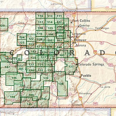
NAT GEO Colorado trail maps
NAT GEO Colorado trail maps
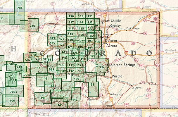
Producten op de overzichtskaart
Klik op een product om naar de detailpagina te gaan.
- Wandelkaart 110 Leadville & Fairplay - Colorado - Nat Geo
- Wandelkaart 127 Aspen - Independence Pass - Colorado USA
- Wandelkaart 137 Pikes Peak & Cañon City - Nat Geo
- Wandelkaart 138 Sangre de Cristo Mountains - Nat Geo
- Wandelkaart 139 La Garita Caldera - Cochetopa - Nat Geo
- Wandelkaart 140 Weminuche Wilderness Colorado USA - Nat Geo
- Wandelkaart 141 Telluride- Silverton- Ouray & Lake City - Nat Geo
- Wandelkaart 144 Durango & Cortez- Colorado - Natgeo
- Wandelkaart 208 Colorado National Monument - Natgeo
- Wandelkaart 245 Black Canyon of the Gunnison NP - Natgeo
Artikelen uit dezelfde regio

Wandelkaart 110 Leadville & Fairplay - Colorado - Nat Geo • 9781566953641
TOPO Wandelkaart 110 - Leadville & Fairplay - Colorado - National Geographic Productomschrijving: Leadville & Fairplay zijn locaties in de Amerikaanse staat Colorado. De dorpen liggen op een hoogte van 3000 meter, en zijn daarmee een van de hoogstgelegen steden van Colorado. In het begin van de tijd van de goudkoorts ontstond de nederzetting, in het jaar 1859. Het is een meestal rustige st…

Wandelkaart 113 Cowdrey- North Sand Hills Colorado - Nat Geo • 9781566952880
Cowdrey- North Sand Hills Colorado - Nat Geo Productomschrijving: Geniet van de overvloedige recreatieve mogelijkheden in het noorden van Colorado met de hulp van National Geographic's Trails Illustrated kaart van Cowdrey en North Sand Hills. Deskundig onderzocht en gemaakt in samenwerking met de U.S. Forest Service, Bureau of Land Management, Colorado State Parks en anderen, zal de kaart …

Wandelkaart 1302 Colorado 14'ers- Noord - Nat geo • 9781566956994
TOPO Wandelkaart 1302 - Colorado 14'ers- Noord - Natgeo Productomschrijving: De Colorado 14'ers bestaat uit 14 van de meest indrukwekkende bergmassieven in Colorado, verdeeld over drie verschillende regio's als Front Range, Momsquito Tenmile Ranges en de Sawatch Range. een indrukwekkende locatie om te gaan trekken uiteraard. Front Range: Mount Bierstadt, Mount Evans, Grays Peak, Longs …

Wandelkaart 200 Rocky Mountain NP- Colorado - Nat Geo • 9781566953429
TOPO Wandelkaart 200 - Rocky Mountain NP- Colorado - National Geographic Productomschrijving: Rocky Mountain National Park is een Amerikaans nationaal park in de Southern Rocky Mountains in het noorden van de staat Colorado. Rocky Mountain National Park bezit majestueuze berggezichten, gevarieerde klimaten en omgevingen – van bossen tot bergtoendra – en makkelijk te bereiken wandelroutes e…
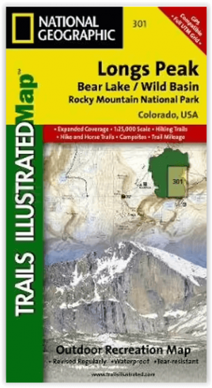
Wandelkaart 301 Longs Peak -Trails Illustrated N. Trails - Nat Geo • 9781566954310
Wandelkaart 301 Longs Peak - Nat Geo Productomschrijving: Engelse omschrijving: Towering over the Rocky Mountains stands the 14,259 foot high Longs Peak. National Geographic's Trails Illustrated map of Longs Peak and the surrounding south-east areas of Rocky Mountain National Park is designed to meet the needs of those who are looking for a phenomenal climbing experience as well as fo…