

Wandelkaart 140 Weminuche Wilderness Colorado USA - Nat Geo
Big Meadows - Williams Creek - Rio Grande reservoirs

Korte omschrijving
Wandelkaarten Colorado, USA van National Geographic. Ideaal voor tochten in Verenigde Staten van Amerika (USA).
Wandelkaart Weminuche Wilderness Colorado USA - Nat Geo Productomschrijving: De Weminuche Wilderness overspant de Continental Divide en is met bijna een half miljoen hectare het grootste wil...

Specificaties
- Uitgever: National Geographic
- ISBN-13: 9781566952910
- HOOFDCATEGORIEËN: Wandelkaart
- Activiteiten: Wandelen, Hiking & Trekking
- Auteur: National Geographic
- Regio: Colorado, USA
- Land: Verenigde Staten van Amerika (USA)
- Waterafstotende kaart: Nat Geo waterproof series
- TOPO's & Stafkaarten: Topografisch wandelen
- Schaal: 1:63360
- Taal: Engels
Volledige omschrijving
Wandelkaart Weminuche Wilderness Colorado USA - Nat Geo
Productomschrijving: De Weminuche Wilderness overspant de Continental Divide en is met bijna een half miljoen hectare het grootste wildernisgebied in Colorado. Deskundig onderzocht en gemaakt in samenwerking met lokale landbeheerders, biedt National Geographic's Trails Illustrated kaart van de Weminuche Wilderness een ongeëvenaard hulpmiddel voor het verkennen van dit ruige land en zijn fragiele ecosystemen. Deze kaart biedt ongeëvenaarde details van het hele park, met inbegrip van belangrijke gebieden zoals Big Meadows, Williams Creek, en Rio Grande reservoirs, de Rio Grande en Animas rivieren, Wolf Creek, en drie veertieners, Mount Eolus, Sunlight Peak, en Windom Peak, gelegen in de San Juan Mountains. De kaart omvat ook de nationale bossen van San Juan en Rio Grande.
Andere kenmerken op deze kaart zijn: Mount Eolus, Needle Mountains, Rio Grande National Forest, San Juan Mountains, San Juan National Forest, Sunlight Peak, Weminuche Wilderness, Windom Peak, Wolf Creek Pass.
Engelse omschrijving: The Weminuche Wilderness spans the Continental Divide and at nearly a half million acres is the largest wilderness area in Colorado. Expertly researched and created in partnership with local land management agencies, National Geographic's Trails Illustrated map of Weminuche Wilderness provides an unparalleled tool for exploring this rugged country and its fragile ecosystems. This map offers unmatched detail of the entire park including such key areas of interest as Big Meadows, Williams Creek, and Rio Grande reservoirs, the Rio Grande and Animas rivers, Wolf Creek, and three fourteeners, Mount Eolus, Sunlight Peak, and Windom Peak, located in the San Juan Mountains. The map also includes the San Juan and Rio Grande national forests.
Other features found on this map include: Mount Eolus, Needle Mountains, Rio Grande National Forest, San Juan Mountains, San Juan National Forest, Sunlight Peak, Weminuche Wilderness, Windom Peak, Wolf Creek Pass.
With miles of clearly marked trails including portions of the Colorado and Continental Divide trails, and the scenic roadways Silver Thread and San Juan Skyway, this map will prove invaluable whether you're taking in the scenery on foot or by car. Whatever the season, you'll find this map a useful tool in pursuing a host of recreational activities. Alpine ski areas, hard surface and mountain bike routes, campgrounds, trailheads, boat ramps, fishing access, and ATV trails are all noted, as are historic townsites and mining camps. The map base includes contour lines and elevations for summits, passes and many lakes.
Every Trails Illustrated map is printed on "Backcountry Tough" waterproof, tear-resistant paper. A full UTM grid is printed on the map to aid with GPS navigation.
Locatie op kaart
Overzichtskaarten
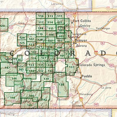
NAT GEO Colorado trail maps
NAT GEO Colorado trail maps
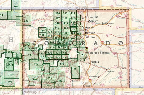
Producten op de overzichtskaart
Klik op een product om naar de detailpagina te gaan.
- Wandelkaart 110 Leadville & Fairplay - Colorado - Nat Geo
- Wandelkaart 127 Aspen - Independence Pass - Colorado USA
- Wandelkaart 137 Pikes Peak & Cañon City - Nat Geo
- Wandelkaart 138 Sangre de Cristo Mountains - Nat Geo
- Wandelkaart 139 La Garita Caldera - Cochetopa - Nat Geo
- Wandelkaart 140 Weminuche Wilderness Colorado USA - Nat Geo
- Wandelkaart 141 Telluride- Silverton- Ouray & Lake City - Nat Geo
- Wandelkaart 144 Durango & Cortez- Colorado - Natgeo
- Wandelkaart 208 Colorado National Monument - Natgeo
- Wandelkaart 245 Black Canyon of the Gunnison NP - Natgeo
Artikelen uit dezelfde regio

Wandelkaart 110 Leadville & Fairplay - Colorado - Nat Geo • 9781566953641
TOPO Wandelkaart 110 - Leadville & Fairplay - Colorado - National Geographic Productomschrijving: Leadville & Fairplay zijn locaties in de Amerikaanse staat Colorado. De dorpen liggen op een hoogte van 3000 meter, en zijn daarmee een van de hoogstgelegen steden van Colorado. In het begin van de tijd van de goudkoorts ontstond de nederzetting, in het jaar 1859. Het is een meestal rustige st…

Reisgids Colorado USA - Lonely Planet • 9781837583751
Reisgids Colorado - Lonely Planet Productomschrijving: Spectacular vistas, endless powder runs and mountain towns with echoes of the Old West – Colorado is a place that has long beckoned people to adventure. Lonely Planet will get you to the heart of Colorado, with amazing travel experiences and the best planning advice. Hit the slopes in Aspen, discover the Old West in Durango or marv…
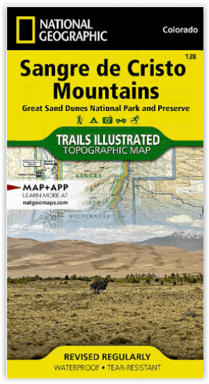
Wandelkaart 138 Sangre de Cristo Mountains - Nat Geo • 9781566953511
Sangre de Cristo Mountains - Great Sand Dunes NP & Preserve Productomschrijving: Verken de kroon van de zuidelijke Rockies en het wonder van de Great Sand Dunes met National Geographic's Trails Illustrated kaart van Sangre de Cristo Mountains. Gemaakt in samenwerking met lokale land management agentschappen, deze deskundig onderzochte kaart levert ongeëvenaarde details en nuttige informati…

Wandelkaart 1202 Colorado Trail Noord - Nat geo • 9781566956956
TOPO Wandelkaart 1202 - Colorado Trail Noord - Natgeo Productomschrijving: The Colorado Trail is een lange-afstands wandelroute van om en bij de 782 km. Deze loopt van de mond van Waterton Canyon ten zuidwesten van Denver tot Durango in Colorado. Zijn hoogste punt is 4,045 meter boven zeeniveau, en de overgrote meerderheid van de route loopt boven de 3,000 meter. Ondanks zijn hoog gelegen …

Wandelkaart 200 Rocky Mountain NP- Colorado - Nat Geo • 9781566953429
TOPO Wandelkaart 200 - Rocky Mountain NP- Colorado - National Geographic Productomschrijving: Rocky Mountain National Park is een Amerikaans nationaal park in de Southern Rocky Mountains in het noorden van de staat Colorado. Rocky Mountain National Park bezit majestueuze berggezichten, gevarieerde klimaten en omgevingen – van bossen tot bergtoendra – en makkelijk te bereiken wandelroutes e…