

Wandelkaart 138 Sangre de Cristo Mountains - Nat Geo
Great Sand Dunes NP & Preserve
Korte omschrijving
Wandelkaarten Colorado, USA van National Geographic. Ideaal voor tochten in Verenigde Staten van Amerika (USA).
Sangre de Cristo Mountains - Great Sand Dunes NP & Preserve Productomschrijving: Verken de kroon van de zuidelijke Rockies en het wonder van de Great Sand Dunes met National Geographic's Tra...

Specificaties
- Uitgever: National Geographic
- ISBN-13: 9781566953511
- HOOFDCATEGORIEËN: Wandelkaart
- Activiteiten: Wandelen, Hiking & Trekking
- Auteur: National Geographic
- Regio: Colorado, USA
- Land: Verenigde Staten van Amerika (USA)
- Waterafstotende kaart: Nat Geo waterproof series
- Nationale parken: Great Sand Dunes NP & Preserve, Colorado USA
- TOPO's & Stafkaarten: Topografisch wandelen
- Schaal: 1:75000
- Taal: Engels
Volledige omschrijving
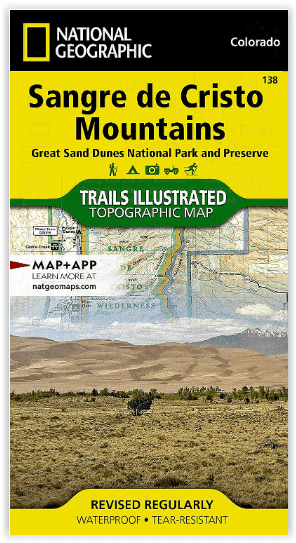
Sangre de Cristo Mountains - Great Sand Dunes NP & Preserve
Productomschrijving: Verken de kroon van de zuidelijke Rockies en het wonder van de Great Sand Dunes met National Geographic's Trails Illustrated kaart van Sangre de Cristo Mountains. Gemaakt in samenwerking met lokale land management agentschappen, deze deskundig onderzochte kaart levert ongeëvenaarde details en nuttige informatie voor ervaren outdoor liefhebbers en casual bezoekers.
Enkele van de belangrijkste gebieden zijn: Great Sand Dunes National Park and Preserve, Arkansas Headwaters Recreation Area, DeWeese Reservoir, Blanca Wetlands, San Luis State Park, en delen van de Rio Grande en San Isabel national forest.
Omvat: Blanca Peak, Challenger Point, Crestone Needle, Crestone Peak, Electric Peak, Great Sand Dunes National Park, Great Sand Dunes National Preserve, Humboldt Peak, Kit Carson Mountain, Little Bear Peak, Mount Lindsey, Promontory Divide, Rio Grande National Forest, San Isabel National Forest, Sangre de Cristo Wilderness.
Engelse omschrijving: Explore the majesty of the southern Rockies and the wonder of the Great Sand Dunes with National Geographic's Trails Illustrated map of Sangre de Cristo Mountains. Created in partnership with local land management agencies, this expertly researched map delivers unmatched detail and helpful information for experienced outdoor enthusiasts and casual visitors alike. Some of the key areas of interest included are: Great Sand Dunes National Park and Preserve, Arkansas Headwaters Recreation Area, DeWeese Reservoir, Blanca Wetlands, San Luis State Park, and portions of Rio Grande and San Isabel national forests.
This map can guide you off the beaten path and back again with miles of mapped trails and clearly marked trailheads. Cyclists will appreciate the detail paid to the many hard surface and mountain bike trails in the region. Road types are differentiated as well, so you know if the route you choose is a paved, dirt, four-wheel-drive, or high-clearance road. Some of the many recreation features noted include campgrounds, cross country ski areas, snowmobile trails, fishing areas, boat launches, rafting put-ins, and scenic viewpoints. The map base includes contour lines and elevations for summits, passes and major lakes.
Every Trails Illustrated map is printed on "Backcountry Tough" waterproof, tear-resistant paper. A full UTM grid is printed on the map to aid with GPS navigation.
Locatie op kaart
Overzichtskaarten
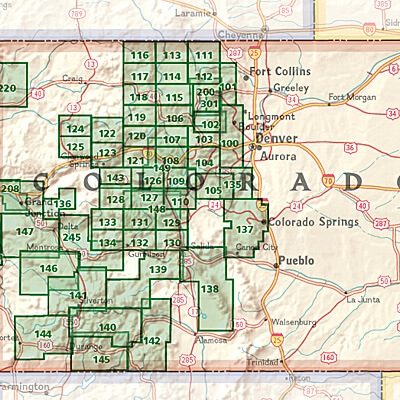
NAT GEO Colorado trail maps
NAT GEO Colorado trail maps
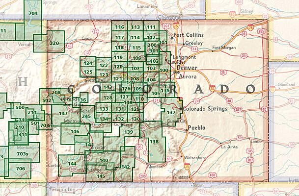
Producten op de overzichtskaart
Klik op een product om naar de detailpagina te gaan.
- Wandelkaart 110 Leadville & Fairplay - Colorado - Nat Geo
- Wandelkaart 127 Aspen - Independence Pass - Colorado USA
- Wandelkaart 137 Pikes Peak & Cañon City - Nat Geo
- Wandelkaart 138 Sangre de Cristo Mountains - Nat Geo
- Wandelkaart 139 La Garita Caldera - Cochetopa - Nat Geo
- Wandelkaart 140 Weminuche Wilderness Colorado USA - Nat Geo
- Wandelkaart 141 Telluride- Silverton- Ouray & Lake City - Nat Geo
- Wandelkaart 144 Durango & Cortez- Colorado - Natgeo
- Wandelkaart 208 Colorado National Monument - Natgeo
- Wandelkaart 245 Black Canyon of the Gunnison NP - Natgeo
Artikelen uit dezelfde regio

Wandelkaart 113 Cowdrey- North Sand Hills Colorado - Nat Geo • 9781566952880
Cowdrey- North Sand Hills Colorado - Nat Geo Productomschrijving: Geniet van de overvloedige recreatieve mogelijkheden in het noorden van Colorado met de hulp van National Geographic's Trails Illustrated kaart van Cowdrey en North Sand Hills. Deskundig onderzocht en gemaakt in samenwerking met de U.S. Forest Service, Bureau of Land Management, Colorado State Parks en anderen, zal de kaart …

Landkaart Wegenkaart Colorado State guide map - Nat Geo • 9781566957779
Wegenkaart Colorado State guide map - Nat Geo Productomschrijving: National Geographic's Colorado Guide Map is designed to meet the needs of travelers with detailed and accurate cartography and loads of helpful information about the state's many attractions. Cities and towns are easy to find with the map's helpful index. Highways, roadways, toll roads, scenic routes, and other roads are cl…
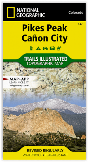
Wandelkaart 137 Pikes Peak & Cañon City - Nat Geo • 9781566953986
Pikes Peak & Cañon City Colorado - National Geographic Productomschrijving: De hoogste top in de zuidelijke Front Range van de Rocky Mountains, Pikes Peak torent boven Colorado Springs uit als een granieten schildwacht. Verken deze en andere geologische attracties zoals Garden of the Gods, Florrisant Fossil Beds en de Royal Gorge met National Geographic's Trails Illustrated kaart van Pikes…

Wandelkaart 1304 Colorado Backpack Loops- Noord - Natgeo • 9781566957557
TOPO Wandelkaart 1304 - Colorado Backpack Loops- Noord - Natgeo Productomschrijving: Colorado is gelend voor zijn outdoor recreatrieve opportuniteiten. Eén van deze bezigheden is uiteraard backcountry & hiking. De Colorado Backpack Loops North Topographic Map Guide omavt de dozijn aan cirkelvormige wandelroutes geselecteerd door het personeel van National Geographic voor hun diversiteit, h…
Reisgids American Rockies - Lonely Planet • 9781837588169
The American Rockies - Lonely Planet Productomschrijving: Lonely Planet's local travel experts reveal all you need to know to plan the trip of a lifetime in this latest edition of our guide to the American Rockies. Discover the American Rockies' most popular experiences and best kept secrets from scrambling up to the saddle of Cathedral Rock to watch the sunset turn Sedona red, to getting …