

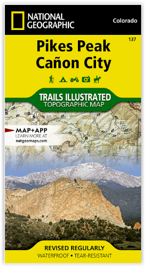
Wandelkaart 137 Pikes Peak & Cañon City - Nat Geo
Colorado Springs- Pike National Forest & Pikes Peak
Korte omschrijving
Wandelkaarten Colorado, USA van National Geographic. Ideaal voor tochten in Verenigde Staten van Amerika (USA).
Pikes Peak & Cañon City Colorado - National Geographic Productomschrijving: De hoogste top in de zuidelijke Front Range van de Rocky Mountains, Pikes Peak torent boven Colorado Springs uit a...

Specificaties
- Uitgever: National Geographic
- ISBN-13: 9781566953986
- HOOFDCATEGORIEËN: Wandelkaart
- Activiteiten: Wandelen, Hiking & Trekking
- Auteur: National Geographic
- Regio: Colorado, USA
- Land: Verenigde Staten van Amerika (USA)
- Waterafstotende kaart: Nat Geo waterproof series
- Schaal: 1:63360
- Taal: Engels
Volledige omschrijving
Pikes Peak & Cañon City Colorado - National Geographic
Productomschrijving: De hoogste top in de zuidelijke Front Range van de Rocky Mountains, Pikes Peak torent boven Colorado Springs uit als een granieten schildwacht. Verken deze en andere geologische attracties zoals Garden of the Gods, Florrisant Fossil Beds en de Royal Gorge met National Geographic's Trails Illustrated kaart van Pikes Peak, Canon City. Deze kaart, die deskundig is onderzocht en gemaakt in samenwerking met lokale beheerders, toont de belangrijkste bezienswaardigheden zoals Pike National Forest, Arkansas River, Mueller State Park, Dome Rock State Wildlife Area, Rampart Reservoir en Shelf Road. De gedrukte versie van de kaart bevat gedetailleerde inzetstukken van Garden of the Gods en Palmer Park.
Omvat: Colorado Springs, Pike National Forest, Pikes Peak, Royal Gorge, Seven Falls.
Engelse omschrijving: The highest summit in the southern Front Range of the Rocky Mountains, Pikes Peak towers over Colorado Springs like a granite sentinel. Explore this and other geological attractions such as Garden of the Gods, Florrisant Fossil Beds, and the Royal Gorge with National Geographic's Trails Illustrated map of Pikes Peak, Canon City. Expertly researched and created in partnership with local land management agencies, this map features key points of interest including Pike National Forest; Arkansas River; Mueller State Park; Dome Rock State Wildlife Area; and Rampart Reservoir and Shelf Road recreation areas. The print version of the map includes detailed insets of Garden of the Gods and Palmer Park.
This map can guide you off the beaten path and back again with miles of mapped trails including mountain bike routes, and snowmobile, ATV, and interpretive trails. Scenic byways are clearly noted for those taking in the scenery by car. Recreation features are clearly marked, including campgrounds, trailheads, fishing and boat access, and cross country ski and climbing areas. The map base includes contour lines and elevations for summits, passes and many lakes.
Every Trails Illustrated map is printed on "Backcountry Tough" waterproof, tear-resistant paper. A full UTM grid is printed on the map to aid with GPS navigation.
Locatie op kaart
Overzichtskaarten
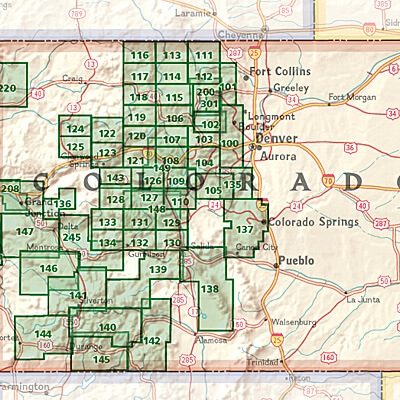
NAT GEO Colorado trail maps
NAT GEO Colorado trail maps
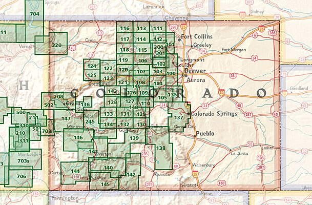
Producten op de overzichtskaart
Klik op een product om naar de detailpagina te gaan.
- Wandelkaart 110 Leadville & Fairplay - Colorado - Nat Geo
- Wandelkaart 127 Aspen - Independence Pass - Colorado USA
- Wandelkaart 137 Pikes Peak & Cañon City - Nat Geo
- Wandelkaart 138 Sangre de Cristo Mountains - Nat Geo
- Wandelkaart 139 La Garita Caldera - Cochetopa - Nat Geo
- Wandelkaart 140 Weminuche Wilderness Colorado USA - Nat Geo
- Wandelkaart 141 Telluride- Silverton- Ouray & Lake City - Nat Geo
- Wandelkaart 144 Durango & Cortez- Colorado - Natgeo
- Wandelkaart 208 Colorado National Monument - Natgeo
- Wandelkaart 245 Black Canyon of the Gunnison NP - Natgeo
Artikelen uit dezelfde regio

Wandelkaart 220 Dinosaur National Monument - Natgeo • 9781566954037
TOPO Wandelkaart 220 - Dinosaur National Monument - Nat Geo Productomschrijving: Dinosaur National Monument in de United States, gelegen op de zuidoostelijke kant van de Uinta Mountains op de grens tussen Colorado en Utah met invloeden van de Green & Yampa Rivieren. Ondanks dat het grootste deel ervan gelegen is in Moffat County, Colorado, is Dinosaur gelegen in Utah net ten noorden van de…

Reisgids Colorado USA - Lonely Planet • 9781837583751
Reisgids Colorado - Lonely Planet Productomschrijving: Spectacular vistas, endless powder runs and mountain towns with echoes of the Old West – Colorado is a place that has long beckoned people to adventure. Lonely Planet will get you to the heart of Colorado, with amazing travel experiences and the best planning advice. Hit the slopes in Aspen, discover the Old West in Durango or marv…

Wandelkaart 140 Weminuche Wilderness Colorado USA - Nat Geo • 9781566952910
Wandelkaart Weminuche Wilderness Colorado USA - Nat Geo Productomschrijving: De Weminuche Wilderness overspant de Continental Divide en is met bijna een half miljoen hectare het grootste wildernisgebied in Colorado. Deskundig onderzocht en gemaakt in samenwerking met lokale landbeheerders, biedt National Geographic's Trails Illustrated kaart van de Weminuche Wilderness een ongeëvenaard hul…

Wandelkaart 134 Black Mesa - Curecanti Pass Colorado - Nat Geo • 9781566954303
Wandelkaart Black Mesa - Curecanti Pass Colorado - Nat Geo Productomschrijving: Outdoor enthousiastelingen die de afgelegen en ongetemde bergen van westelijk Colorado willen verkennen zullen zich verbazen over National Geographic's Trails Illustrated kaart van Black Mesa en Curecanti Pass. Gemaakt in samenwerking met de U.S. Forest Service, dekt deze deskundig onderzochte kaart, het recrea…

Wandelkaart 110 Leadville & Fairplay - Colorado - Nat Geo • 9781566953641
TOPO Wandelkaart 110 - Leadville & Fairplay - Colorado - National Geographic Productomschrijving: Leadville & Fairplay zijn locaties in de Amerikaanse staat Colorado. De dorpen liggen op een hoogte van 3000 meter, en zijn daarmee een van de hoogstgelegen steden van Colorado. In het begin van de tijd van de goudkoorts ontstond de nederzetting, in het jaar 1859. Het is een meestal rustige st…