

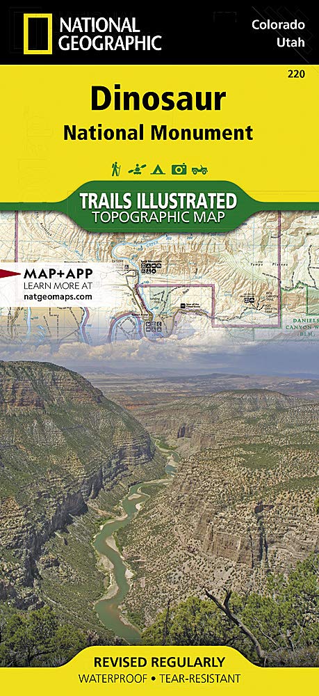
Wandelkaart 220 Dinosaur National Monument - Natgeo
Gelegen op de zuidoostelijke kant van de Uinta Mountains.
Korte omschrijving
Wandelkaarten Colorado, USA van National Geographic. Ideaal voor tochten in Verenigde Staten van Amerika (USA).
TOPO Wandelkaart 220 - Dinosaur National Monument - Nat Geo Productomschrijving: Dinosaur National Monument in de United States, gelegen op de zuidoostelijke kant van de Uinta Mountains op d...

Specificaties
- Uitgever: National Geographic
- ISBN-13: 9781566954037
- HOOFDCATEGORIEËN: Wandelkaart
- Activiteiten: Wandelen, Hiking & Trekking
- Auteur: National Geographic
- Regio: Colorado, USA
- Land: Verenigde Staten van Amerika (USA)
- TOPO's & Stafkaarten: Topografisch wandelen
- Schaal: 1:75000
- Taal: Engels
Volledige omschrijving
TOPO Wandelkaart 220 - Dinosaur National Monument - Nat Geo
Productomschrijving: Dinosaur National Monument in de United States, gelegen op de zuidoostelijke kant van de Uinta Mountains op de grens tussen Colorado en Utah met invloeden van de Green & Yampa Rivieren. Ondanks dat het grootste deel ervan gelegen is in Moffat County, Colorado, is Dinosaur gelegen in Utah net ten noorden van de stad Jensen, Utah.
Engelse omschrijving: National Geographic's Trails Illustrated map of Dinosaur National Monument, which straddles the state lines of northwest Colorado and northeast Utah, is the perfect recreational map for this stunning monument. Within its craggy hills, you can discover pieces of a long ago world where the largest land creatures of all time once roamed and died. Expertly researched and created in partnership with local land management agencies, this map features key points of interest including Dinosaur Quarry, Red Fleet State Park, Canyon of Lodore, Harpers Corner, and the town of Dinosaur. The map also highlights many popular routes for scenic driving including Dinosaur Diamond, Harpers Corner, Tour of the Tilted Rocks, Browns Park, and Jones Hole.
This map features detailed topography with shaded relief, elevations, easy-to-read trails, and clearly defined, color-coded boundaries for parks, wildlife study areas, public lands, and areas of critical environmental concern. Information about the region, its history and culture, geology, and natural history are provided as well. Those exploring by boat will appreciate the inclusion of river campsites, river mileage and access points along the Yampa and Green rivers. Other recreation features noted include campgrounds, boat launches, interpretive trails, fishing access, scenic viewpoints, and visitor centers. Every Trails Illustrated map is printed on "Backcountry Tough" waterproof, tear-resistant paper. A full UTM grid is printed on the map to aid with GPS navigation.
Other features found on this map include: Canyon of Lodore, Diamond Gulch, Dinosaur, Douglas Mountain, Split Mountain, Yampa River.
.jpg)
Locatie op kaart
Artikelen uit dezelfde regio

Wandelkaart 139 La Garita Caldera - Cochetopa - Nat Geo • 9781566953399
TOPO Wandelkaart 139 - La Garita Caldera - Cochetopa - National Gepgraphic Productomschrijving: La Garita Caldera is de krater van een grote dode vulkaan in het zuidwesten van Colorado in de Verenigde Staten. De caldera, een ringvormige bergketen die centraal binnen een cluster van kleinere caldera's ligt, maakt deel uit van het San Juan Gebergte in de Rocky Mountains. Engelse omschrij…

Wandelkaart 127 Aspen - Independence Pass - Colorado USA • 9781566953580
TOPO Wandelkaart 127 - Aspen - Independence Pass - Colorado USA Productomschrijving: Independence Pass in Aspen Colorado is een uitmuntende wandellocatie. Deze omvat een topografische wandelkaart die echt tot de verbeelding spreekt. Een subliem exemplaar als het over wandelen gaat. Engelse omschrijving: Independence Pass, originally known as Hunter Pass, is a high mountain pass in cen…
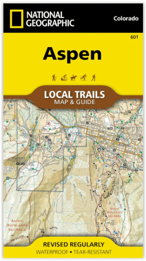
Wandelkaart 601 Aspen Local Trails - Nat Geo • 9781566957526
Wandelkaart Aspen Local Trails - Nat Geo Productomschrijving: Met meer dan 320 km aan wandelpaden op korte afstand van de stad hebben bezoekers van Aspen een benijdenswaardig probleem: met al deze paden om uit te kiezen, waar moeten ze beginnen? De Aspen Local Trails-kaart helpt bij het beantwoorden van deze vraag - waar gaan de plaatselijke bewoners heen als ze een korte wandeling met het…

Wandelkaart 110 Leadville & Fairplay - Colorado - Nat Geo • 9781566953641
TOPO Wandelkaart 110 - Leadville & Fairplay - Colorado - National Geographic Productomschrijving: Leadville & Fairplay zijn locaties in de Amerikaanse staat Colorado. De dorpen liggen op een hoogte van 3000 meter, en zijn daarmee een van de hoogstgelegen steden van Colorado. In het begin van de tijd van de goudkoorts ontstond de nederzetting, in het jaar 1859. Het is een meestal rustige st…

Wandelkaart 134 Black Mesa - Curecanti Pass Colorado - Nat Geo • 9781566954303
Wandelkaart Black Mesa - Curecanti Pass Colorado - Nat Geo Productomschrijving: Outdoor enthousiastelingen die de afgelegen en ongetemde bergen van westelijk Colorado willen verkennen zullen zich verbazen over National Geographic's Trails Illustrated kaart van Black Mesa en Curecanti Pass. Gemaakt in samenwerking met de U.S. Forest Service, dekt deze deskundig onderzochte kaart, het recrea…