

Wandelkaart 110 Leadville & Fairplay - Colorado - Nat Geo
Hier ontstond de goudkoorts en ontstonden nederzettingen

Korte omschrijving
Wandelkaarten Colorado, USA van National Geographic. Ideaal voor tochten in Verenigde Staten van Amerika (USA).
TOPO Wandelkaart 110 - Leadville & Fairplay - Colorado - National Geographic Productomschrijving: Leadville & Fairplay zijn locaties in de Amerikaanse staat Colorado. De dorpen liggen op een...

Specificaties
- Uitgever: National Geographic
- ISBN-13: 9781566953641
- HOOFDCATEGORIEËN: Wandelkaart
- Activiteiten: Wandelen, Hiking & Trekking
- Auteur: National Geographic
- Regio: Colorado, USA
- Land: Verenigde Staten van Amerika (USA)
- TOPO's & Stafkaarten: Topografisch wandelen
- Schaal: 1:40000
- Taal: Engels
Volledige omschrijving
TOPO Wandelkaart 110 - Leadville & Fairplay - Colorado - National Geographic
Productomschrijving: Leadville & Fairplay zijn locaties in de Amerikaanse staat Colorado. De dorpen liggen op een hoogte van 3000 meter, en zijn daarmee een van de hoogstgelegen steden van Colorado. In het begin van de tijd van de goudkoorts ontstond de nederzetting, in het jaar 1859. Het is een meestal rustige stad, en de straten rondom het dorp worden weinig bereden. Hoewel het dorp tijdens de goudkoortstijd werd gesticht, bleef er nog lange tijd activiteit in de mijnen, er werd lange tijd goud- en zilvererts gewonnen, tot in medio 20e eeuw.
Engelse omschrijving: Nestled in a high mountain valley surrounded by snowcapped peaks, former mining town Leadville, Colorado is the highest incorporated city in the United States. National Geographic's Trails Illustrated map of Leadville and Fairplay is designed to meet the needs of outdoor enthusiasts by combining valuable information with unmatched detail of this popular destination for year-round recreation. Created in partnership with local land management agencies, this expertly researched map features key areas of interest including Twin Lakes and Clear Creek reservoirs; Arkansas River; Mount Massive Lakes; and portions of the Top of the Rockies and Collegiate Peaks scenic byways.
With miles of clearly marked trails including portions of the Colorado and Continental Divide trails, this map will prove invaluable in your exploration of the region. Trail mileage between intersections will help you choose the path that's right for you. Cyclists will appreciate the detail paid to the many paved and mountain bike trails in the region. Cross country ski, snowmobile, and motorized trails are included as well. Road types are differentiated, so you know if the route you choose is a four-wheel-drive or high-clearance road. The map base includes contour lines and elevations for summits and passes. Recreation features are clearly marked, including campgrounds, trailheads, river access, fishing areas, boat launches, and more. Every Trails Illustrated map is printed on "Backcountry Tough" waterproof, tear-resistant paper. A full UTM grid is printed on the map to aid with GPS navigation.
Other features found on this map include: Buffalo Peaks Wilderness, Mosquito Range, Mount Sherman, Pike National Forest, San Isabel National Forest.
Locatie op kaart
Overzichtskaarten
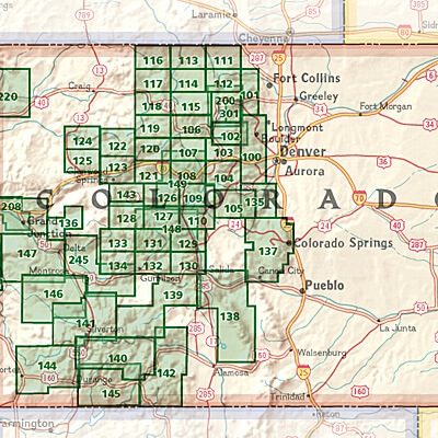
NAT GEO Colorado trail maps
NAT GEO Colorado trail maps
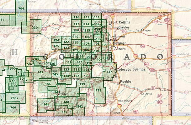
Producten op de overzichtskaart
Klik op een product om naar de detailpagina te gaan.
- Wandelkaart 110 Leadville & Fairplay - Colorado - Nat Geo
- Wandelkaart 127 Aspen - Independence Pass - Colorado USA
- Wandelkaart 137 Pikes Peak & Cañon City - Nat Geo
- Wandelkaart 138 Sangre de Cristo Mountains - Nat Geo
- Wandelkaart 139 La Garita Caldera - Cochetopa - Nat Geo
- Wandelkaart 140 Weminuche Wilderness Colorado USA - Nat Geo
- Wandelkaart 141 Telluride- Silverton- Ouray & Lake City - Nat Geo
- Wandelkaart 144 Durango & Cortez- Colorado - Natgeo
- Wandelkaart 208 Colorado National Monument - Natgeo
- Wandelkaart 245 Black Canyon of the Gunnison NP - Natgeo
Artikelen uit dezelfde regio

Wandelkaart 134 Black Mesa - Curecanti Pass Colorado - Nat Geo • 9781566954303
Wandelkaart Black Mesa - Curecanti Pass Colorado - Nat Geo Productomschrijving: Outdoor enthousiastelingen die de afgelegen en ongetemde bergen van westelijk Colorado willen verkennen zullen zich verbazen over National Geographic's Trails Illustrated kaart van Black Mesa en Curecanti Pass. Gemaakt in samenwerking met de U.S. Forest Service, dekt deze deskundig onderzochte kaart, het recrea…

Landkaart Wegenkaart Colorado State guide map - Nat Geo • 9781566957779
Wegenkaart Colorado State guide map - Nat Geo Productomschrijving: National Geographic's Colorado Guide Map is designed to meet the needs of travelers with detailed and accurate cartography and loads of helpful information about the state's many attractions. Cities and towns are easy to find with the map's helpful index. Highways, roadways, toll roads, scenic routes, and other roads are cl…

Wandelkaart 1303 Colorado 14ers- Zuid - Nat geo • 9781566957007
TOPO Wandelkaart 1303 - Colorado 14ers- Zuid - Natgeo Productomschrijving: De colorad 14'ers Zuid, zijn de 14 meest indrukwekkende bergmassieven in het zuiden van Colorado. De locatie is onderverdeeld in drie regio's zoals: De Elk Range, San Juan Range & Sangre De Cristo Range. Elk Range: Capitol Peak, Castle Peak, Conundrum Peak, Maroon Peak, North Maroon Peak, Pyramid Peak, Snowmass …

Wandelkaart 100 Boulder & Golden Colorado USA - Nat Geo • 9781566953351
Wandelkaart Boulder & Golden Colorado USA - Nat Geo Productomschrijving: National Geographic's Trails Illustrated kaart van Boulder en Golden combineert ongeëvenaarde details met nuttige informatie om een onschatbaar hulpmiddel te bieden om het meeste uit uw verkenning van de centrale Colorado Front Range te halen. Deskundig onderzocht en gemaakt in samenwerking met lokale landbeheerders. …

Reisgids Colorado USA - Insight Guides (ENG) • 9781839053795
Reisgids Colorado - Insight Guides (ENG) Productomschrijving: From deciding when to go, to choosing what to see when you arrive, this guide to Colorado is all you need to plan your perfect trip, with insider information on must-see, top attractions like Denver Art Museum, Pikes Peak and the Old Fort National Historic Site, and cultural gems like the serrated alpine peaks of the Rocky Mount…