

Wandelkaart 208 Colorado National Monument - Natgeo
Recreatie regio's doorheen Colorado's 'Grand Valley'

Korte omschrijving
Wandelkaarten Colorado, USA van National Geographic. Ideaal voor tochten in Verenigde Staten van Amerika (USA).
TOPO Wandelkaart 208 - Colorado National Monument - Natgeo Productomschrijving: recreatie regio's doorheen Colorado's 'Grand Valley' omvatten de steden: Grand Junction, Fruita, Palisade & Lo...

Specificaties
- Uitgever: National Geographic
- ISBN-13: 9781566954013
- HOOFDCATEGORIEËN: Wandelkaart
- Activiteiten: Wandelen, Hiking & Trekking
- Auteur: National Geographic
- Regio: Colorado, USA
- Land: Verenigde Staten van Amerika (USA)
- Regionale parken: McInnis Canyons National Conservation Area, Colorado USA
- TOPO's & Stafkaarten: Topografisch wandelen
- Schaal: 1:70000
- Taal: Engels
Volledige omschrijving
TOPO Wandelkaart 208 - Colorado National Monument - Natgeo
Productomschrijving: recreatie regio's doorheen Colorado's 'Grand Valley' omvatten de steden: Grand Junction, Fruita, Palisade & Loma. Dit veel gebruikte gebied is gekend onder de de mensen die in Colorado wonen. Dit gebied is nationaal bekend voor zijn speciale mountainbiketrails en evengoed gekend voor de start van het Kokepelli Trail, die loopt tot aan het stadje Moab.
Engelse omschrijving: National Geographic's Trails Illustrated map of Colorado National Monument details the high use recreation areas throughout Colorado's Grand Valley surrounding the towns of Grand Junction, Fruita, Palisade, and Loma. This popular region features some of the State's most acclaimed mountain biking, hiking and ATV trails including the start of the renowned Kokepelli Trail, which extends down to Moab, UT.
Created in partnership with local land management agencies, this expertly researched map features key areas of interest including McInnis Canyon National Conservation Area; James M. Robb-Colorado River and Highline Lake state parks; Grand Valley Open OHV Area; Little Book Cliffs Wild Horse Range; Westwater Canyon; and Black Ridge Canyons Wilderness. An inset of Colorado National Monument provides greater detail of this remarkable area.
.png)
Locatie op kaart
Overzichtskaarten
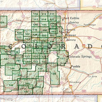
NAT GEO Colorado trail maps
NAT GEO Colorado trail maps
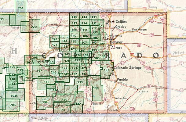
Producten op de overzichtskaart
Klik op een product om naar de detailpagina te gaan.
- Wandelkaart 110 Leadville & Fairplay - Colorado - Nat Geo
- Wandelkaart 127 Aspen - Independence Pass - Colorado USA
- Wandelkaart 137 Pikes Peak & Cañon City - Nat Geo
- Wandelkaart 138 Sangre de Cristo Mountains - Nat Geo
- Wandelkaart 139 La Garita Caldera - Cochetopa - Nat Geo
- Wandelkaart 140 Weminuche Wilderness Colorado USA - Nat Geo
- Wandelkaart 141 Telluride- Silverton- Ouray & Lake City - Nat Geo
- Wandelkaart 144 Durango & Cortez- Colorado - Natgeo
- Wandelkaart 208 Colorado National Monument - Natgeo
- Wandelkaart 245 Black Canyon of the Gunnison NP - Natgeo
Artikelen uit dezelfde regio

Wandelkaart 1304 Colorado Backpack Loops- Noord - Natgeo • 9781566957557
TOPO Wandelkaart 1304 - Colorado Backpack Loops- Noord - Natgeo Productomschrijving: Colorado is gelend voor zijn outdoor recreatrieve opportuniteiten. Eén van deze bezigheden is uiteraard backcountry & hiking. De Colorado Backpack Loops North Topographic Map Guide omavt de dozijn aan cirkelvormige wandelroutes geselecteerd door het personeel van National Geographic voor hun diversiteit, h…

Wandelkaart 103 Winter Park, Central City & Rollins Pass • 9781566952767
Wandelkaart Winter Park, Central City & Rollins Pass Productomschrijving: National Geographic's Trails Illustrated kaart van Winter Park, Central City en Rollins Pass biedt ongeëvenaarde details voor outdoor enthousiastelingen die het hele jaar door willen genieten van de recreatieve mogelijkheden in de zuidelijke delen van Roosevelt en Arapaho National Forest. Deskundig onderzocht en gema…
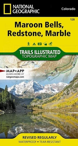
Wandelkaart 128 Maroon Bells- Redstond & Marble - Nat Geo • 9781566952484
TOPO Wandelkaart 128 - Maroon Bells- Redstond & Marble - National Geographic Productomschrijving: De Maroon Bells zijn 2 bergtoppen in de Elk Mountains, Maroon Peak & North Maroon Peak, met een dikke half kilometer gescheiden. De liggen liggen op de grens tussen Pitkin County & Gunnison County, Colorado, United States Engelse omschrijving: Colorado's Maroon Bells are the most photograp…

Reisgids Colorado - Insight Guides ENG • 9781786715319
Colorado - Insight Guides ENG Productomschrijving: The Rocky Mountain State of Colorado offers soaring peaks, world-class skiing and vibrant cities that lure travellers from all over the world to America's alpine heartland. Be inspired to visit by the new edition of Insight Guide Colorado, a comprehensive full-colour guide to the state. Inside Insight Guide Colorado: A fully-overh…

Wandelkaart 127 Aspen - Independence Pass - Colorado USA • 9781566953580
TOPO Wandelkaart 127 - Aspen - Independence Pass - Colorado USA Productomschrijving: Independence Pass in Aspen Colorado is een uitmuntende wandellocatie. Deze omvat een topografische wandelkaart die echt tot de verbeelding spreekt. Een subliem exemplaar als het over wandelen gaat. Engelse omschrijving: Independence Pass, originally known as Hunter Pass, is a high mountain pass in cen…