

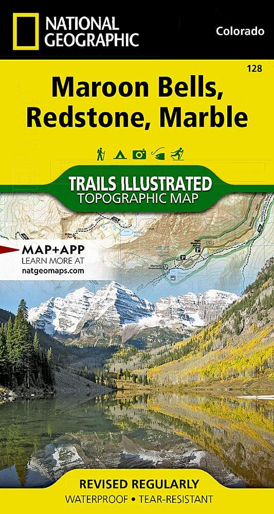
Wandelkaart 128 Maroon Bells- Redstond & Marble - Nat Geo
De Maroon Bells zijn 2 bergtoppen in de Elk Mountains
Korte omschrijving
Wandelkaarten Colorado, USA van National Geographic. Ideaal voor tochten in Verenigde Staten van Amerika (USA).
TOPO Wandelkaart 128 - Maroon Bells- Redstond & Marble - National Geographic Productomschrijving: De Maroon Bells zijn 2 bergtoppen in de Elk Mountains, Maroon Peak & North Maroon Peak, met ...

Specificaties
- Uitgever: National Geographic
- ISBN-13: 9781566952484
- HOOFDCATEGORIEËN: Wandelkaart
- Auteur: National Geographic
- Regio: Colorado, USA
- Land: Verenigde Staten van Amerika (USA)
- TOPO's & Stafkaarten: Topografisch wandelen
- Schaal: 1:40000
- Taal: Engels
Volledige omschrijving
TOPO Wandelkaart 128 - Maroon Bells- Redstond & Marble - National Geographic
Productomschrijving: De Maroon Bells zijn 2 bergtoppen in de Elk Mountains, Maroon Peak & North Maroon Peak, met een dikke half kilometer gescheiden. De liggen liggen op de grens tussen Pitkin County & Gunnison County, Colorado, United States
Engelse omschrijving: Colorado's Maroon Bells are the most photographed peaks in North America. National Geographic's Trails Illustrated map of Maroon Bells, Redstone, Marble offers unparalleled detail for outdoor enthusiasts exploring the aspen forests, clear creeks, high alpine lakes, and towering granite peaks of this magnificent region. Created in partnership with local land management agencies, this expertly researched map features key areas of interest including White River and Gunnison national forests; Raggeds and Maroon Bells - Snowmass wilderness areas; Crystal and Roaring Fork rivers; Conundrum Hot Springs; and Snowmass Ski Area.
With miles of mapped trails, this map can guide you off the beaten path and back again. Cyclists will appreciate the detail paid to the many hard surface and mountain bike trails in the region. The West Elk Loop Scenic Byway is noted for those wishing to take in the scenery by car. The map base includes contour lines and elevations for summits, passes and many lakes. Many recreation features are noted, including campgrounds, fishing areas, trailheads, alpine and cross country ski areas, and snowmobile trails. Survival tips and information about wilderness conduct are included as well. Every Trails Illustrated map is printed on "Backcountry Tough" waterproof, tear-resistant paper. A full UTM grid is printed on the map to aid with GPS navigation.
Other features found on this map include: Capitol Peak, Elk Mountains, Gunnison National Forest, Maroon Bells-Snowmass Wilderness, Maroon Peak, North Maroon Peak, Pyramid Peak, Raggeds Wilderness, Snowmass Mountain, White River National Forest.

Locatie op kaart
Artikelen uit dezelfde regio

Landkaart Wegenkaart Colorado State guide map - Nat Geo • 9781566957779
Wegenkaart Colorado State guide map - Nat Geo Productomschrijving: National Geographic's Colorado Guide Map is designed to meet the needs of travelers with detailed and accurate cartography and loads of helpful information about the state's many attractions. Cities and towns are easy to find with the map's helpful index. Highways, roadways, toll roads, scenic routes, and other roads are cl…

Wandelkaart 1303 Colorado 14ers- Zuid - Nat geo • 9781566957007
TOPO Wandelkaart 1303 - Colorado 14ers- Zuid - Natgeo Productomschrijving: De colorad 14'ers Zuid, zijn de 14 meest indrukwekkende bergmassieven in het zuiden van Colorado. De locatie is onderverdeeld in drie regio's zoals: De Elk Range, San Juan Range & Sangre De Cristo Range. Elk Range: Capitol Peak, Castle Peak, Conundrum Peak, Maroon Peak, North Maroon Peak, Pyramid Peak, Snowmass …

Wandelkaart 1304 Colorado Backpack Loops- Noord - Natgeo • 9781566957557
TOPO Wandelkaart 1304 - Colorado Backpack Loops- Noord - Natgeo Productomschrijving: Colorado is gelend voor zijn outdoor recreatrieve opportuniteiten. Eén van deze bezigheden is uiteraard backcountry & hiking. De Colorado Backpack Loops North Topographic Map Guide omavt de dozijn aan cirkelvormige wandelroutes geselecteerd door het personeel van National Geographic voor hun diversiteit, h…

Wandelkaart 139 La Garita Caldera - Cochetopa - Nat Geo • 9781566953399
TOPO Wandelkaart 139 - La Garita Caldera - Cochetopa - National Gepgraphic Productomschrijving: La Garita Caldera is de krater van een grote dode vulkaan in het zuidwesten van Colorado in de Verenigde Staten. De caldera, een ringvormige bergketen die centraal binnen een cluster van kleinere caldera's ligt, maakt deel uit van het San Juan Gebergte in de Rocky Mountains. Engelse omschrij…
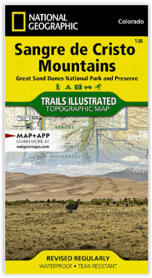
Wandelkaart 138 Sangre de Cristo Mountains - Nat Geo • 9781566953511
Sangre de Cristo Mountains - Great Sand Dunes NP & Preserve Productomschrijving: Verken de kroon van de zuidelijke Rockies en het wonder van de Great Sand Dunes met National Geographic's Trails Illustrated kaart van Sangre de Cristo Mountains. Gemaakt in samenwerking met lokale land management agentschappen, deze deskundig onderzochte kaart levert ongeëvenaarde details en nuttige informati…