

Wandelkaart 144 Durango & Cortez- Colorado - Natgeo
Alle outes in de regio Durango & Cortez in Colorado

Korte omschrijving
Wandelkaarten Colorado, USA van National Geographic. Ideaal voor tochten in Verenigde Staten van Amerika (USA).
TOPO Wandelkaart 144 - Durango & Cortez- Colorado - Natgeo Productomschrijving: Deze kaart biedt u alle soorten routes aan in de regio tussen Durango & Cortez in Colrado. UIteraard hebben wi...

Specificaties
- Uitgever: National Geographic
- ISBN-13: 9781566954631
- HOOFDCATEGORIEËN: Wandelkaart
- Activiteiten: Wandelen, Hiking & Trekking
- Auteur: National Geographic
- Regio: Colorado, USA
- Land: Verenigde Staten van Amerika (USA)
- TOPO's & Stafkaarten: Topografisch wandelen
- Schaal: 1:63360
- Taal: Engels
Volledige omschrijving
TOPO Wandelkaart 144 - Durango & Cortez- Colorado - Natgeo
Productomschrijving: Deze kaart biedt u alle soorten routes aan in de regio tussen Durango & Cortez in Colrado. UIteraard hebben wij het hier over de wandelroutes, maar eveneens kan er hier aan moutainbiken worden gedaan, of paardrijden op dezelfde routes.
Engelse omschrijving: National Geographic's Trails Illustrated map of Durango and Cortez provides unparalleled detail of this culturally significant area of southwestern Colorado. Expertly researched and created in partnership with the U.S. Forest Service, the Bureau of Land Management and others, the map will guide you throughout your recreation or adventure in the area, regardless of the season. The map's coverage includes San Juan National Forest, Mesa Verde National Park, McPhee Reservoir and Recreation Area, Animas River and Valley, Canyon of the Ancients National Monument and Durango Mountain Ski Area.
This map can guide you off the beaten path and back again with a wide variety of trails, including trails for hiking, biking and motorized vehicles, plus city and primitive trails, the Animas River Trail and Colorado Trail. The map base includes contour lines and elevations for summits and passes. Recreation and adventure points of interest for all seasons are marked as well, including campgrounds and campsites, alpine and cross-country ski areas, trailheads and interpretive trails, rock climbing and fishing areas, boat launch and whitewater access points, scenic viewpoints and wildlife viewing areas. In addition, the map lists regional attractions along with their descriptions along with useful contact information of both public and private organizations involved in maintaining the region. Every Trails Illustrated map is printed on "Backcountry Tough" waterproof, tear-resistant paper. A full UTM grid is printed on the map to aid with GPS navigation.
Other features found on this map include: Durango, Hesperus Mountain, La Plata Mountains, Mesa Verde National Park, San Juan National Forest, Sharkstooth Peak.
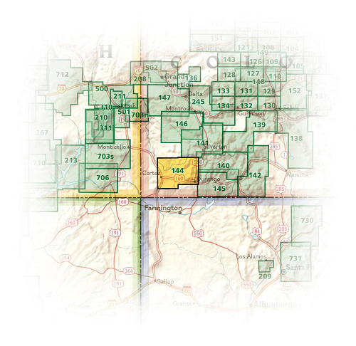
Locatie op kaart
Overzichtskaarten
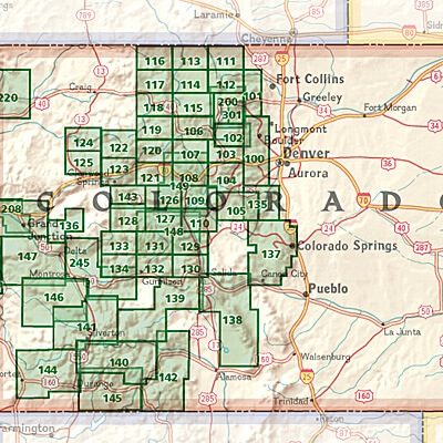
NAT GEO Colorado trail maps
NAT GEO Colorado trail maps
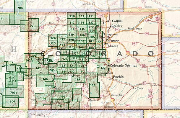
Producten op de overzichtskaart
Klik op een product om naar de detailpagina te gaan.
- Wandelkaart 110 Leadville & Fairplay - Colorado - Nat Geo
- Wandelkaart 127 Aspen - Independence Pass - Colorado USA
- Wandelkaart 137 Pikes Peak & Cañon City - Nat Geo
- Wandelkaart 138 Sangre de Cristo Mountains - Nat Geo
- Wandelkaart 139 La Garita Caldera - Cochetopa - Nat Geo
- Wandelkaart 140 Weminuche Wilderness Colorado USA - Nat Geo
- Wandelkaart 141 Telluride- Silverton- Ouray & Lake City - Nat Geo
- Wandelkaart 144 Durango & Cortez- Colorado - Natgeo
- Wandelkaart 208 Colorado National Monument - Natgeo
- Wandelkaart 245 Black Canyon of the Gunnison NP - Natgeo
Artikelen uit dezelfde regio

Wandelkaart 113 Cowdrey- North Sand Hills Colorado - Nat Geo • 9781566952880
Cowdrey- North Sand Hills Colorado - Nat Geo Productomschrijving: Geniet van de overvloedige recreatieve mogelijkheden in het noorden van Colorado met de hulp van National Geographic's Trails Illustrated kaart van Cowdrey en North Sand Hills. Deskundig onderzocht en gemaakt in samenwerking met de U.S. Forest Service, Bureau of Land Management, Colorado State Parks en anderen, zal de kaart …

Wandelkaart 100 Boulder & Golden Colorado USA - Nat Geo • 9781566953351
Wandelkaart Boulder & Golden Colorado USA - Nat Geo Productomschrijving: National Geographic's Trails Illustrated kaart van Boulder en Golden combineert ongeëvenaarde details met nuttige informatie om een onschatbaar hulpmiddel te bieden om het meeste uit uw verkenning van de centrale Colorado Front Range te halen. Deskundig onderzocht en gemaakt in samenwerking met lokale landbeheerders. …
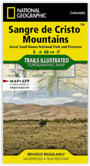
Wandelkaart 138 Sangre de Cristo Mountains - Nat Geo • 9781566953511
Sangre de Cristo Mountains - Great Sand Dunes NP & Preserve Productomschrijving: Verken de kroon van de zuidelijke Rockies en het wonder van de Great Sand Dunes met National Geographic's Trails Illustrated kaart van Sangre de Cristo Mountains. Gemaakt in samenwerking met lokale land management agentschappen, deze deskundig onderzochte kaart levert ongeëvenaarde details en nuttige informati…

Wandelkaart 1303 Colorado 14ers- Zuid - Nat geo • 9781566957007
TOPO Wandelkaart 1303 - Colorado 14ers- Zuid - Natgeo Productomschrijving: De colorad 14'ers Zuid, zijn de 14 meest indrukwekkende bergmassieven in het zuiden van Colorado. De locatie is onderverdeeld in drie regio's zoals: De Elk Range, San Juan Range & Sangre De Cristo Range. Elk Range: Capitol Peak, Castle Peak, Conundrum Peak, Maroon Peak, North Maroon Peak, Pyramid Peak, Snowmass …

Reisgids Colorado USA - Lonely Planet • 9781837583751
Reisgids Colorado - Lonely Planet Productomschrijving: Spectacular vistas, endless powder runs and mountain towns with echoes of the Old West – Colorado is a place that has long beckoned people to adventure. Lonely Planet will get you to the heart of Colorado, with amazing travel experiences and the best planning advice. Hit the slopes in Aspen, discover the Old West in Durango or marv…