

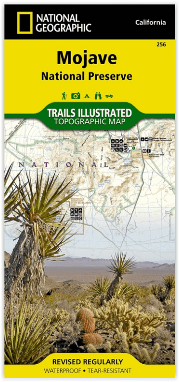
Wandelkaart 256 Mojave National park California - Nat Geo
De samenloop van de Mojave- Sonoran en Great Basin woestijn
Korte omschrijving
Wandelkaarten Californië, USA van National Geographic. Ideaal voor tochten in Verenigde Staten van Amerika (USA).
Wandelkaart - Mojave National park California - Nat Geo Productomschrijving: Gelegen op de samenloop van de Mojave, Sonoran, en Great Basin woestijn regio's, Mojave National Preserve is een ...

Specificaties
- Uitgever: National Geographic
- ISBN-13: 9781566953832
- HOOFDCATEGORIEËN: Wandelkaart
- Activiteiten: Wandelen, Hiking & Trekking
- Auteur: National Geographic
- Regio: Californië, USA
- Land: Verenigde Staten van Amerika (USA)
- Nationale parken: Mojave NP, California USA
- TOPO's & Stafkaarten: Topografisch wandelen
- Schaal: 1:125000
- Taal: Engels
Volledige omschrijving
Wandelkaart - Mojave National park California - Nat Geo
Productomschrijving: Gelegen op de samenloop van de Mojave, Sonoran, en Great Basin woestijn regio's, Mojave National Preserve is een van de meest diverse woestijn omgevingen in de wereld. Verken de Joshua Tree bossen, zandduinen, vulkanische sintelkegels, kilometershoge bergen en uitgestrekte vergezichten van deze unieke regio met National Geographic's Trails Illustrated kaart van Mojave National Preserve. Deze kaart is gemaakt in samenwerking met lokale landbeheerders en bevat belangrijke bezienswaardigheden zoals Kelso Depot, Hole-in-the-Wall, Mitchell Caverns, Rock Springs, Clark Mountain, Cinder Cone Lava Beds, en de historische Mojave Road.
Engelse omschrijving: Located at the confluence of the Mojave, Sonoran, and Great Basin desert regions, Mojave National Preserve is one of the most diverse desert environments in the world. Explore the Joshua Tree forests, sand dunes, volcanic cinder cones, mile-high mountains, and vast vistas of this unique region with National Geographic's Trails Illustrated map of Mojave National Preserve. Created in partnership with local land management agencies, this expertly researched map features key areas of interest including Kelso Depot, Hole-in-the-Wall, Mitchell Caverns, Rock Springs, Clark Mountain, Cinder Cone Lava Beds, and the historic Mojave Road.
Designed with a wide range of visitors in mind, this map features detailed and easy-to-read trails, accurate road network, safety tips, and contact information for local agencies. A handy summary of over twenty points of interest will help you plan your visit. Park regulations and base temperature charts for Soda Springs and Granite Mountains are also included. Recreation features and amenities are clearly marked, including campgrounds, trailheads, interpretive trails, ranger stations, gas stations, lodging, and food services. The map base includes contour lines and elevations for summits.
Every Trails Illustrated map is printed on "Backcountry Tough" waterproof, tear-resistant paper. A full UTM grid is printed on the map to aid with GPS navigation.
Other features found on this map include: Bristol Mountains, Clark Mountain, Devils Playground, Granite Mountains, Ivanpah Lake, Mojave Desert, Mojave National Preserve, Mojave River, Providence Mountains, Shadow Valley, Silver Lake, Soda Lake.
Locatie op kaart
Overzichtskaarten

NAT GEO California trail maps
NAT GEO California trail maps

Producten op de overzichtskaart
Klik op een product om naar de detailpagina te gaan.
- Wandelkaart 205 Sequoia & Kings Canyon NP - California
- Wandelkaart 218 Redwood National & State Parks - Nat Geo
- Wandelkaart 221 Death Valley NP - Nevada - Natgeo
- Wandelkaart 226 Joshua Tree NP - California - Nat Geo
- Wandelkaart 256 Mojave National park California - Nat Geo
- Wandelkaart 306 Yosemite SW- Yosemite Valley - Nat Geo
- Wandelkaart 307 Yosemite NP North West - Nat Geo
- Wandelkaart 308 Yosemite NE- Tuolumne Meadows - Nat Geo
Artikelen uit dezelfde regio
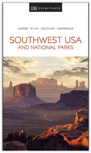
Reisgids USA Southwest & National Parks - DK Eyewitness • 9780241365519
USA Southwest & National Parks Omvat: Arizona, Las Vegas, Southern Utah, the Four Corners & New Mexico. Productomschrijving: Staar naar de diepten van de Grand Canyon, ervaar de glitter en glamour van de Las Vegas strip, beklim de rotsachtige overspanningen van Arches National Park of wandel door het historische Santa Fe: alles wat u moet weten is overzichtelijk weergegeven in kleurgec…

Wandelkaart 226 Joshua Tree NP - California - Nat Geo • 9781566953009
TOPO Wandelkaart 226 - Joshua Tree NP- California - Nat Geo Productomschrijving: Het Joshua Tree National Park is een nationaal park in het zuiden van de staat Californië in de Verenigde Staten, ten oosten van het gebied tussen Los Angeles en San Diego en ten noorden van Palm Springs. De afmetingen zijn ongeveer 100 km van oost naar west, en 50 km van noord naar zuid. Engelse omschrij…

Reisgids The Rough Guide to California - Rough Guides • 9781839058592
The Rough Guide to California - Rough Guides Productomschrijving: De volledig bijgewerkte The Rough Guide to California is de definitieve gids voor de meest bezochte staat in de VS. Ontdek de hoogtepunten van Californië met prachtige fotografie, gemakkelijk te gebruiken kaarten en meer lijsten en informatie dan ooit tevoren. De Rough Guide to California bevat leuke en avontuurlijke reisrou…

Reisgids Los Angeles California - Top 10 - DK Eyewitness • 9780241367957
DK Eyewitness TOP 10 Los Angeles California Omvat: West Hollywood and Midtown, Santa Monica Bay, Downtown & Coastal Orange County Productomschrijving: Ga wandelen in de Hollywood Hills, breng tijd door op Venice Beach, verken Beverly Hills of bezoek het Los Angeles County Museum of Art. Van de Top 10 stranden tot de Top 10 bioscopen - ontdek het beste van Los Angeles met deze gebruiksv…

Wandelkaart 812 Los Padres Nat. Forest East - Natgeo • 9781566955805
TOPO Wandelkaart 812 - Los Padres Nat. Forest East - Natgeo Productomschrijving: Los Padres National Forest is een bosgebied in Amerika, meerbepaald in oost- en centraal California. Het bos is uitermate gekend voor mountainbikers en hikers. Engelse omschrijving: One of the most diverse National Forests in the United States, Los Padres National Forest provides recreation opportunities f…