

Wandelkaart 1001 - John Muir Trail - Nat Geo
Doorkruist Yosemite- Kings Canyon en Sequoia National Park

Korte omschrijving
Wandelkaarten Californië, USA van National Geographic. Ideaal voor tochten in Verenigde Staten van Amerika (USA).
TOPO Wandelkaart 1001 - John Muir Trail - National Geographic Productomschrijving: De John Muir Trail - is een langeafstandswandelpad in het Sierra Nevada-gebergte in de Amerikaanse staat Ca...

Specificaties
- Uitgever: National Geographic
- ISBN-13: 9781566956895
- HOOFDCATEGORIEËN: Wandelkaart
- Activiteiten: Wandelen, Hiking & Trekking
- Auteur: National Geographic
- Regio: Californië, USA
- Land: Verenigde Staten van Amerika (USA)
- Lange afstand wandelroutes: John Muir Way (215 km)
- TOPO's & Stafkaarten: Topografisch wandelen
- Schaal: 1:63360
- Taal: Engels
- Iconische Wandelroutes: John Miur Trail, California USA
- Scotlands Great Trails: John Mir Way
Volledige omschrijving
TOPO Wandelkaart 1001 - John Muir Trail - National Geographic
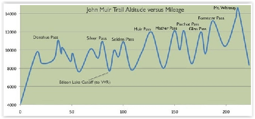
Productomschrijving: De John Muir Trail - is een langeafstandswandelpad in het Sierra Nevada-gebergte in de Amerikaanse staat Californië. Het is vernoemd naar de Schots-Amerikaanse natuurvorser en schrijver John Muir, die een cruciale rol speelde in de bescherming van de nationale parken van Californië. Het 338,6 kilometer lange pad doorkruist Yosemite, Kings Canyon en Sequoia National Park. Het merendeel van het pad (zo'n 260 km) valt samen met de Pacific Crest Trail, dat van de Mexicaanse grens naar de Canadese loopt.
Engelse omschrijving: National Geographic's Map Guide of the John Muir Trail is an indispensable tool for navigating one of the most famous trails in the United States. Expertly researched and created in partnership with local land management agencies, this product provides detailed topographic maps, interesting history, a waypoint table, information about wilderness safety, and key points of interest you will encounter along the trail. A resupply location chart shows shipping address/contact information, distances, and services available at each resupply point. Each map page has a detailed trail profile that shows the elevation changes you will encounter. Also, the John Muir Trail is highlighted and centered on each page so you can easily track your progress.
The maps start at the northern terminus in Yosemite Valley and progress along the ridge of the Sierra Nevada, past Devils Postpile, and end at the highest point in the lower 48 on the top of Mount Whitney. Along the way you will pass through; Yosemite National Park, Ansel Adams Wilderness, Devils Postpile National Monument, John Muir Wilderness, Kings Canyon National Park, and finally, Sequoia National Park and Mount Whitney. A 21-day sample itinerary is included as well. Every Topographic Map Guide is printed on "Backcountry Tough" waterproof, tear-resistant paper. A full UTM grid is printed on the map to aid with GPS navigation.
Other features found on this map include: Ansel Adams Wilderness, Bridalveil Fall, El Capitan, Illilouette Falls, Inyo National Forest, John Muir Wilderness, Kings Canyon National Park, Lake Thomas A Edison, Lower Yosemite Fall, Middle Palisade, Mount Agassiz, Mount Darwin, Mount Muir, Mount Pinchot, Mount Powell, Mount Ritter, Mount Russell, Mount Tyndall, Mount Whitney, Mount Williamson, Nevada Fall, North Palisade, Ribbon Fall, Ritter Range, Sequoia National Park, Sierra National Forest, Sierra Nevada, Split Mountain, Upper Yosemite Falls, Vernal Fall, Yosemite National Park, Yosemite Valley.
.png)
Locatie op kaart
Artikelen uit dezelfde regio

Wandelkaart 811 Angeles National Forest - Natgeo • 9781566955775
Wandelkaart Angeles National Forest, California USA (9781566955775) National Geographic Productomschrijving: Een bosgebied in de onmiskenbare San Gabriel Mountains in het zuiden van de Amerikaanse staat Californië. Het bestaat uit twee delen die van elkaar gescheiden worden door de Soledad Canyon. Het Angeles National Forest reikt tot net over de grens met San Bernardino County in het oost…

Reisgids Californie et parcs nationaux Coups de Coeur - Gallimard • 9782742467693
Reisgids Californie et parcs nationaux - Gallimard Productomschrijving: Het Amerikaanse California, is groot als mede hun Nationale parken. • 180 photos, des cartes, des plans et des infographies • Les sites et visites incontournables • Toutes nos adresses coups de cœur • Un reportage inédit qui vous emmène hors des sentiers battus • Deux itinéraires de 4 jours, l'un à San Fra…

Reisgids Anwb Extra Los Angeles- San Francisco & Las Vegas - Anwb • 9789018049782
Reisgids Los Angeles- San Francisco & Las Vegas - Anwv Productomschrijving: ANWB Extra reisgids Los Angeles, San Francisco en Las Vegas - Amerika Ontdek Los Angeles, San Francisco en Las Vegas met de compleet vernieuwde reisgids ANWB Extra Los Angeles, San Francisco en Las Vegas! In deze Amerikaanse driehoek komt elke vakantieganger aan zijn trekken. De natuurliefhebber in Big Sur en d…
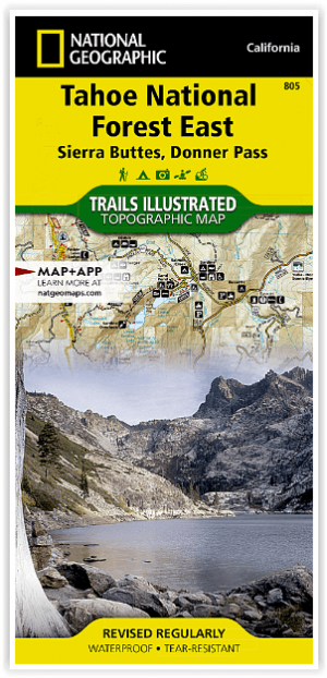
Wandelkaart 805 Tahoe Nat. Forest East - Sierra Buttes - Nat Geo • 9781566953818
Tahoe National Forest East - Sierra Buttes - Nat Geo Omvat: Donner Pass, Eldorado National Forest, Granite Chief Wilderness, Mosquito Ridge, Plumas National Forest, Sawtooth Ridge, Tahoe National Forest, Truckee. Engelse omschrijving: Expertly researched and created in partnership with the U.S. Forest Service and others, National Geographic's Trails Illustrated map of Yuba and American…

Reisgids California - DK Eyewitness • 9780241309292
Reisgids California - DK Eyewitness Productomschrijving: Tour a winery in Napa, hike to the waterfalls in Yosemite National Park or ride a classic cable car in San Francisco: everything you need to know is clearly laid out within colour-coded chapters. Discover the best of California with this indispensable travel guide. Detailed chapters with area maps cover: Los Angeles; South Centra…