

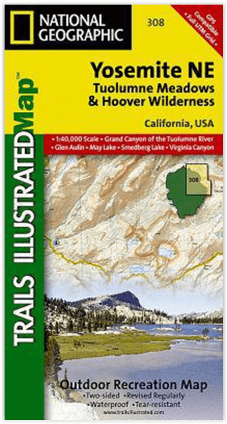
Wandelkaart 308 Yosemite NE- Tuolumne Meadows - Nat Geo
Om te voldoen aan de behoeften van outdoor enthousiastelingen
Korte omschrijving
Wandelkaarten Californië, USA van National Geographic. Ideaal voor tochten in Verenigde Staten van Amerika (USA).
Yosemite North East - Tuolumne Meadows - Nat Geo Productomschrijving: National Geographic's Trails Illustrated kaart van Yosemite NE: Tuolumne Meadows and Hoover Wilderness is ontworpen om t...

Specificaties
- Uitgever: National Geographic
- ISBN-13: 9781566953696
- HOOFDCATEGORIEËN: Wandelkaart
- Activiteiten: Wandelen, Hiking & Trekking
- Auteur: National Geographic
- Regio: Californië, USA
- Land: Verenigde Staten van Amerika (USA)
- Nationale parken: Yosemeti NP, California USA
- TOPO's & Stafkaarten: Topografisch wandelen
- Schaal: 1:40000
- Taal: Engels
Volledige omschrijving
Yosemite North East - Tuolumne Meadows - Nat Geo
Productomschrijving: National Geographic's Trails Illustrated kaart van Yosemite NE: Tuolumne Meadows and Hoover Wilderness is ontworpen om te voldoen aan de behoeften van outdoor enthousiastelingen door het combineren van waardevolle informatie met ongeëvenaarde details van deze prachtige regio van het park. Deskundig onderzocht en gemaakt in samenwerking met lokale landbeheerders, bevat deze kaart belangrijke punten van belang, waaronder Twin Lakes, Tuolumne River, Grand Canyon of the Tuolumne, en delen van Ansel Adams Wilderness, Mono Basin National Forest Scenic Area, en Yosemite Wilderness.
Met kilometers aan gemarkeerde paden, inclusief delen van de Pacific Crest en John Muir paden, kan deze kaart u van de gebaande paden af leiden en weer terug in enkele van de meest adembenemende landschappen in de Sierras. Trail kilometers tussen de kruispunten zal u helpen kiezen het pad dat voor u geschikt is. Camping, wandelen, wildernis vergunning, en de veiligheid informatie is opgenomen om u te helpen bij het genieten van alles wat het park te bieden heeft. De kaartbasis bevat hoogtelijnen en hoogtes voor toppen, passen en vele meren. Recreatievoorzieningen zijn duidelijk aangegeven, waaronder campings, picknickplaatsen, trailheads, paardenstallen, skigebieden en meer.
Engelse omschrijving: National Geographic's Trails Illustrated map of Yosemite NE: Tuolumne Meadows and Hoover Wilderness is designed to meet the needs of outdoor enthusiasts by combining valuable information with unmatched detail of this magnificent region of the park. Expertly researched and created in partnership with local land management agencies, this map features key points of interest including Twin Lakes, Tuolumne River, Grand Canyon of the Tuolumne, and portions of Ansel Adams Wilderness, Mono Basin National Forest Scenic Area, and Yosemite Wilderness.
With miles of mapped trails including portions of the Pacific Crest and John Muir trails, this map can guide you off the beaten path and back again in some of the most breathtaking scenery in the Sierras. Trail mileage between intersections will help you choose the path that's right for you. Camping, hiking, wilderness permit, and safety information is included to help guide you in enjoying all the park has to offer. The map base includes contour lines and elevations for summits, passes, and many lakes. Recreation features are clearly marked, including campgrounds, picnic areas, trailheads, horse stables, ski areas, and more.
Every Trails Illustrated map is printed on "Backcountry Tough" waterproof, tear-resistant paper. A full UTM grid is printed on the map to aid with GPS navigation.
Other features found on this map include: Ansel Adams Wilderness, Excelsior Mountain, Hoover Wilderness, Inyo National Forest, Matterhorn Peak, Mount Dana, Tioga Pass, Toiyabe National Forest, Yosemite National Park.
Locatie op kaart
Overzichtskaarten

NAT GEO California trail maps
NAT GEO California trail maps

Producten op de overzichtskaart
Klik op een product om naar de detailpagina te gaan.
- Wandelkaart 205 Sequoia & Kings Canyon NP - California
- Wandelkaart 218 Redwood National & State Parks - Nat Geo
- Wandelkaart 221 Death Valley NP - Nevada - Natgeo
- Wandelkaart 226 Joshua Tree NP - California - Nat Geo
- Wandelkaart 256 Mojave National park California - Nat Geo
- Wandelkaart 306 Yosemite SW- Yosemite Valley - Nat Geo
- Wandelkaart 307 Yosemite NP North West - Nat Geo
- Wandelkaart 308 Yosemite NE- Tuolumne Meadows - Nat Geo
Artikelen uit dezelfde regio

Reisgids California Coastal - Lonely Planet • 9781787016781
Reisgids California Coastal - Lonely Planet Productomschrijving: From towering redwoods in foggy Northern California to the perfect sun-kissed surf beaches of Southern California, this slice of Pacific Coast is a knockout beauty. Lonely Planet will get you to the heart of Coastal California, with amazing travel experiences and the best planning advice: Colour maps and images throug…

Reisgids West Coast USA - Insight Guides ENG • 9781786718310
West Coast USA - Insight Guides Productomschrijving: Deze reisgids is een rijk geïllustreerde inspirerende versie over de westkust van de VS en een prachtig souvenir van uw reis. Perfect voor reizigers die op zoek zijn naar een diepere duik in de geschiedenis en cultuur van de bestemming en ideaal om u te inspireren en te helpen bij het plannen van uw reis. Met zijn grote selectie van…
Reisgids Northern California & San Francisco - Lonely Planet • 9781787016071
Northern California & San Francisco - Lonely Planet Productomschrijving: With soaring peaks, vast coastline and the tallest of the world’s trees, Northern California in-spires all who visit to dream that much bigger. Covers: San Francisco, the Bay Area, Napa Valley, Sonoma Valley, Coastal Highway 1, Redding, Gold Country, Lake Tahoe, Yosemite, the Sierra Nevada, Sacramento and more …
Landkaart Wegenkaart Southern California State Guide map- Nat Geo • 9781597750158
Wegenkaart California Southern State Guide map - Nat Geo Productomschrijving: National Geographic's Southern California Guide Map provides travelers with the perfect combination of detail and perspective in a highly functional travel tool. Both comprehensive map and mini-guidebook, this map provides information on many points of interest, the cities of Los Angeles and San Diego, and Sequoi…

Reisgids L'essentiel de Californie - Lonely Planet • 9782816171204
L'essentiel de Californie du Lonely Planet Description de produits: Le guide Lonely Planet qui va à l'essentiel, pour découvrir le meilleur de la Californie. Un guide tout en couleurs, illustré par des centaines de photos. Sonoma Valley, la Pacific Coast Highway, Yosemite, les parcs à thème, San Francisco, Lake Tahoe, Death Valley… tous les incontournables de la région réunis dans ce volum…