

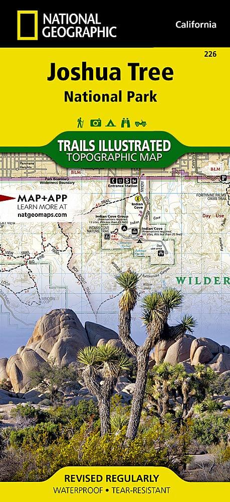
Wandelkaart 226 Joshua Tree NP - California - Nat Geo
Een prachtig gebied tussen Los Angeles en San Diego
Korte omschrijving
Wandelkaarten Californië, USA van National Geographic. Ideaal voor tochten in Verenigde Staten van Amerika (USA).
TOPO Wandelkaart 226 - Joshua Tree NP- California - Nat Geo Productomschrijving: Het Joshua Tree National Park is een nationaal park in het zuiden van de staat Californië in de Verenigde Sta...

Specificaties
- Uitgever: National Geographic
- ISBN-13: 9781566953009
- HOOFDCATEGORIEËN: Wandelkaart
- Activiteiten: Wandelen, Hiking & Trekking
- Auteur: National Geographic
- Regio: Californië, USA
- Land: Verenigde Staten van Amerika (USA)
- Nationale parken: Joshua Tree NP, California USA
- TOPO's & Stafkaarten: Topografisch wandelen
- Schaal: 1:80000
- Taal: Engels
Volledige omschrijving
TOPO Wandelkaart 226 - Joshua Tree NP- California - Nat Geo
Productomschrijving: Het Joshua Tree National Park is een nationaal park in het zuiden van de staat Californië in de Verenigde Staten, ten oosten van het gebied tussen Los Angeles en San Diego en ten noorden van Palm Springs. De afmetingen zijn ongeveer 100 km van oost naar west, en 50 km van noord naar zuid.
Engelse omschrijving: The two distinct ecosystems of the Colorado Desert and the Mojave Desert meet in southeastern California in the Joshua Tree National Park. National Geographic's Trails Illustrated map of the park delivers unmatched detail and valuable information to assist you in your exploration of this fascinating land of surreal geologic features shaped by strong winds, unpredictable torrents of rain, and climatic extremes. Created in partnership with local land management agencies, this expertly researched map features key areas of interest including Black Rock Canyon, Lost Horse Valley, Indian Cove, Cottonwood, Chuckwalla Valley, and the Pinto Mountains.
With miles of clearly marked trails that include mileages between intersections, this map will prove invaluable in your exploration of the park. The map base includes contour lines and elevations for summits and passes. Interesting information about the park, regulations, and safety tips are included as well. Recreation features are clearly marked, including interpretive trails, campgrounds, picnic areas, points of interest, horse camps, and more. Every Trails Illustrated map is printed on "Backcountry Tough" waterproof, tear-resistant paper. A full UTM grid is printed on the map to aid with GPS navigation.
Other features found on this map include: Cadiz Valley, Cathedral City, Coachella Valley, Coxcomb Mountains, Eagle Mountains, Hayfield Lake, Indio, Joshua Tree National Park, Little San Bernardino Mountains, Palm Desert, Rancho Mirage, Twentynine Palms, Yucca Valley.

Locatie op kaart
Overzichtskaarten

NAT GEO California trail maps
NAT GEO California trail maps

Producten op de overzichtskaart
Klik op een product om naar de detailpagina te gaan.
- Wandelkaart 205 Sequoia & Kings Canyon NP - California
- Wandelkaart 218 Redwood National & State Parks - Nat Geo
- Wandelkaart 221 Death Valley NP - Nevada - Natgeo
- Wandelkaart 226 Joshua Tree NP - California - Nat Geo
- Wandelkaart 256 Mojave National park California - Nat Geo
- Wandelkaart 306 Yosemite SW- Yosemite Valley - Nat Geo
- Wandelkaart 307 Yosemite NP North West - Nat Geo
- Wandelkaart 308 Yosemite NE- Tuolumne Meadows - Nat Geo
Artikelen uit dezelfde regio

Wandelkaart 809 Mammoth Lakes - Mono Divide - Nat Geo • 9781566952668
TOPO Wandelkaart 809 - Mammoth Lakes - Mono Divide - National Geographic Productomschrijving: Mammoth Lakes is een stadje in Mono County, California, de enige geintegreerde community in de regio. Gelegen direct ten oosten van Mammoth Mountain. Engelse omschrijving: Explore the magnificent alpine landscape of Mammoth Lakes, Mono Divide with National Geographic's Trails Illustrated map. …
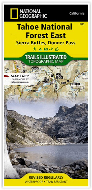
Wandelkaart 805 Tahoe Nat. Forest East - Sierra Buttes - Nat Geo • 9781566953818
Tahoe National Forest East - Sierra Buttes - Nat Geo Omvat: Donner Pass, Eldorado National Forest, Granite Chief Wilderness, Mosquito Ridge, Plumas National Forest, Sawtooth Ridge, Tahoe National Forest, Truckee. Engelse omschrijving: Expertly researched and created in partnership with the U.S. Forest Service and others, National Geographic's Trails Illustrated map of Yuba and American…
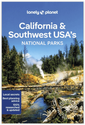
Wandelgids California & Southwest USA's NP's - Lonely Planet • 9781838696061
Wandelgids California & Southwest USA's National Parks Productomschrijving: Lonely Planet's California and Southwest USA's National Parks is uw paspoort voor het meest actuele advies over wat je moet zien en overslaan. Wandel door de Grand Canyon, bewonder Sequoia en jaag op watervallen in Yosemite; allemaal met je vertrouwde reisgenoot. Duik in het hart van de nationale parken van Califor…

Reisgids California - Insight Guides ENG • 9781839053306
Reisgids California - Insight Guides Productomschrijving: Van het beslissen wanneer je gaat tot kiezen wat je gaat zien als je aankomt, dit is alles wat je nodig hebt om je reis te plannen en het beste van Californië te ervaren, met diepgaande insiderinformatie over must-see topattracties zoals Hollywood en verborgen culturele juweeltjes zoals de Pacific Coast Highway. Engelse om…

Wandelkaart 252 Channel Islands National Park - Nat Geo • 9781566954105
Channel Islands National Park - Nat Geo Productomschrijving: De Channel Islands Nationaal Park, gelegen voor de kust van Californië, zijn de thuisbasis van vele unieke soorten flora en fauna. National Geographic's Trails Illustrated kaart van Channel Islands National Park bestrijkt met ongeëvenaard detail de vijf eilanden die het park omvat, inclusief The Nature Conservancy gebied van Sant…