

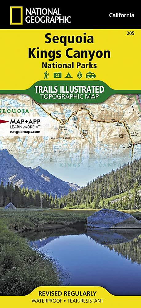
Wandelkaart 205 Sequoia & Kings Canyon NP - California
Gelegen in het zuidelijke deel van de Sierra Nevada
Korte omschrijving
Wandelkaarten Californië, USA van National Geographic. Ideaal voor tochten in Verenigde Staten van Amerika (USA).
TOPO Wandelkaart 205 - Sequoia & Kings Canyon NP Productomschrijving: Sequoia National Park is een nationaal park in het zuidelijke deel van de Sierra Nevada in Californië. Het park grenst a...

Specificaties
- Uitgever: National Geographic
- ISBN-13: 9781566952989
- HOOFDCATEGORIEËN: Wandelkaart
- Activiteiten: Wandelen, Hiking & Trekking
- Auteur: National Geographic
- Regio: Californië, USA
- Land: Verenigde Staten van Amerika (USA)
- Nationale parken: Sequoia & Kings Canyon NP, California USA
- TOPO's & Stafkaarten: Topografisch wandelen
- Schaal: 1:80000
- Taal: Engels
Volledige omschrijving
TOPO Wandelkaart 205 - Sequoia & Kings Canyon NP
Productomschrijving: Sequoia National Park is een nationaal park in het zuidelijke deel van de Sierra Nevada in Californië. Het park grenst aan de noordzijde aan Kings Canyon National Park, en wordt door de National Park Service als geheel beheerd.
Engelse omschrijving: In Sequioa and Kings Canyon National Parks you can walk among the world's largest trees, hike the alpine landscape of the Sierra Crest, and marvel at the towering granite cliffs of one of the deepest canyons in the United States. National Geographic's Trails Illustrated map of Sequoia and Kings Canyon National Parks provides unmatched detail of these parks, meeting the needs of amateur and experienced outdoor enthusiasts alike. Created in partnership with local land management agencies, this expertly researched map features key areas of interest including Sequoia Grove; Giant Sequoia National Monument; John Muir, Golden Trout, Jennie Lakes and Monarch Wilderness Areas; John Muir Trail; Pacific Crest Trail; and Mt. Whitney, the highest peak in the contiguous United States.
With miles of mapped trails in some of the most breathtaking scenery in the entire country, this map can guide you off the beaten path and back again. In addition to detailed and easy-to-read trails, this map includes an accurate road network, campgrounds, scenic overlooks and points of interests, visitor centers and facilities, plus park regulations, backcountry use areas, and contact information for local agencies. The map base includes contour lines and elevations for summits, passes and major lakes. Every Trails Illustrated map is printed on "Backcountry Tough" waterproof, tear-resistant paper. A full UTM grid is printed on the map to aid with GPS navigation.
Other features found on this map include: Cirque Peak, Golden Trout Wilderness, Inyo National Forest, Jennie Lakes Wilderness, John Muir Wilderness, Kings Canyon National Park, Middle Palisade, Monarch Wilderness, Mount Agassiz, Mount Darwin, Mount Goddard, Mount Kaweah, Mount Langley, Mount Muir, Mount Pinchot, Mount Powell, Mount Russell, Mount Sill, Mount Tyndall, Mount Whitney, Mount Williamson, North Palisade, Sequoia National Forest, Sequoia National Park, Sierra National Forest, Sierra Nevada, Split Mountain, Triple Divide Peak.
Locatie op kaart
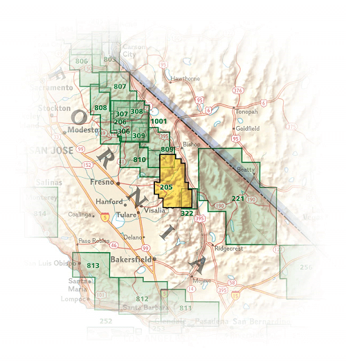
Overzichtskaarten

NAT GEO California trail maps
NAT GEO California trail maps

Producten op de overzichtskaart
Klik op een product om naar de detailpagina te gaan.
- Wandelkaart 205 Sequoia & Kings Canyon NP - California
- Wandelkaart 218 Redwood National & State Parks - Nat Geo
- Wandelkaart 221 Death Valley NP - Nevada - Natgeo
- Wandelkaart 226 Joshua Tree NP - California - Nat Geo
- Wandelkaart 256 Mojave National park California - Nat Geo
- Wandelkaart 306 Yosemite SW- Yosemite Valley - Nat Geo
- Wandelkaart 307 Yosemite NP North West - Nat Geo
- Wandelkaart 308 Yosemite NE- Tuolumne Meadows - Nat Geo
Artikelen uit dezelfde regio

Stadskaart plattegrond San Francisco USA - Borch • 9783866093317
Wandelkaart San Francisco USA - Borch Productomschrijving: Our soft-laminated folded map of San Francisco in the 16th edition shows: San Francisco Downtown 1:13 000, Alcatraz Island 1: 15 000, Golden Gate Park 1:13 000, San Francisco and Region 1:150 000, San Francisco Bay Area 1:400 000, Public Transport San Francisco, Top 30 Sights and USA administrative and time zones. Borch maps are ea…
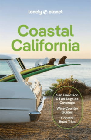
Reisgids California Coastal - Lonely Planet • 9781787016781
Reisgids California Coastal - Lonely Planet Productomschrijving: From towering redwoods in foggy Northern California to the perfect sun-kissed surf beaches of Southern California, this slice of Pacific Coast is a knockout beauty. Lonely Planet will get you to the heart of Coastal California, with amazing travel experiences and the best planning advice: Colour maps and images throug…

Reisgids Experience California - Lonely Planet • 9781838697440
Lonely Planet Experience California Productomschrijving: Inside Lonely Planet's Experience California: Unique experiences to string together an unforgettable trip Inspiring full-color travel photography and maps throughout Highlights and trip builders to help tailor a trip to your personal needs and interests Fresh perspectives to surprise you with things you hadn't thought…

Reisgids The Rough Guide to California - Rough Guides • 9781839058592
The Rough Guide to California - Rough Guides Productomschrijving: De volledig bijgewerkte The Rough Guide to California is de definitieve gids voor de meest bezochte staat in de VS. Ontdek de hoogtepunten van Californië met prachtige fotografie, gemakkelijk te gebruiken kaarten en meer lijsten en informatie dan ooit tevoren. De Rough Guide to California bevat leuke en avontuurlijke reisrou…
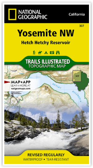

Wandelkaart 307 Yosemite NP North West - Nat Geo • 9781566954129
Yosemite North West - Nat Geo Omvat: Emigrant Wilderness, Lake Eleanor, Stanislaus National Forest, Yosemite National Park. Engelse omschrijving: National Geographic's Trails Illustrated map of Yosemite North West- Hetch Hetchy Reservoir is designed to meet the needs of outdoor enthusiasts by combining valuable information with unmatched detail of this magnificent region of Yosemite Na…