

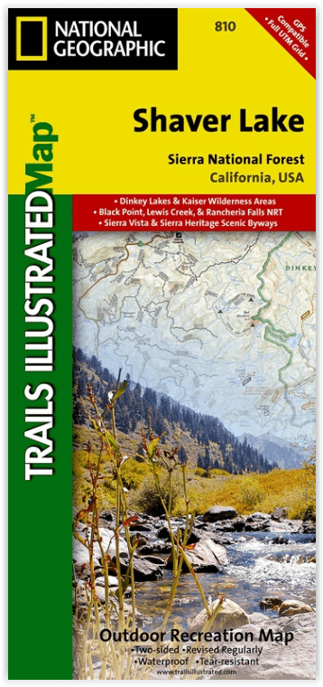
Wandelkaart 810 Shaver Lake - Sierra National Forest - Nat Geo
Sierra National Forest - Yosemite National Park - Sequoia NP
Korte omschrijving
Wandelkaarten Californië, USA van National Geographic. Ideaal voor tochten in Verenigde Staten van Amerika (USA).
Shaver Lake - Sierra National Forest - Nat Geo Omvat: Ansel Adams Wilderness, Bass Lake, Chowchilla Mountains, Courtright Reservoir, Dinkey Lakes Wilderness, John Muir Wilderness, Kaiser Wil...

Specificaties
- Uitgever: National Geographic
- ISBN-13: 9781566952422
- HOOFDCATEGORIEËN: Wandelkaart
- Activiteiten: Wandelen, Hiking & Trekking
- Auteur: National Geographic
- Regio: Californië, USA
- Land: Verenigde Staten van Amerika (USA)
- Waterafstotende kaart: Nat Geo waterproof series
- TOPO's & Stafkaarten: Topografisch wandelen
- Schaal: 1:63360
- Taal: Engels
Volledige omschrijving
Shaver Lake - Sierra National Forest - Nat Geo
Omvat: Ansel Adams Wilderness, Bass Lake, Chowchilla Mountains, Courtright Reservoir, Dinkey Lakes Wilderness, John Muir Wilderness, Kaiser Wilderness, Mammoth Pool Reservoir, Nelson Mountain, Sequoia National Forest, Shaver Lake, Sierra National Forest, Wishon Reservoir, Yosemite National Park.
Engelse omschrijving: National Geographic's Trails Illustrated map of Shaver Lake will help all outdoor enthusiasts navigate their way off the beaten path and back again, around this very popular area of Sierra National Forest between Yosemite National Park and Sequoia National Forest. Clearly marked trailheads will point you to trails that are colored according to their designated usage and have mileage markers between intersections, including National Recreation trails like Columns of the Giants, Rancheria Falls and Lewis Creek Trail. The Kings Wild and Scenic River is also clearly shown along with a river difficulty scale chart, for whitewater rafting. Some of the other recreation features on the map are boat launch and river access points, ski areas, horse stables and scenic views.
This expertly researched map was created in partnership with the U.S. Forest Service, National Park Service and others. It contains descriptions of popular recreation sites, various safety tips, wilderness descriptions and camping regulations and useful contact information. The map base includes contour lines and elevations for summits and peaks. Some key points of interest are Kaiser, Dinkey Lakes, John Muir and Monarch Wildernesses, Millerton Lake State Recreation Area, Huntington Lake and Rancheria Falls. The Sierra Vista and Sierra Heritage Byway are indicated for those who prefer to explore the area by car.
Every Trails Illustrated map is printed on "Backcountry Tough" waterproof, tear-resistant paper. A full UTM grid is printed on the map to aid with GPS navigation.
Locatie op kaart
Artikelen uit dezelfde regio

Reisgids Los Angeles California - Top 10 - DK Eyewitness • 9780241367957
DK Eyewitness TOP 10 Los Angeles California Omvat: West Hollywood and Midtown, Santa Monica Bay, Downtown & Coastal Orange County Productomschrijving: Ga wandelen in de Hollywood Hills, breng tijd door op Venice Beach, verken Beverly Hills of bezoek het Los Angeles County Museum of Art. Van de Top 10 stranden tot de Top 10 bioscopen - ontdek het beste van Los Angeles met deze gebruiksv…

Reisgids Californie et parcs nationaux Coups de Coeur - Gallimard • 9782742467693
Reisgids Californie et parcs nationaux - Gallimard Productomschrijving: Het Amerikaanse California, is groot als mede hun Nationale parken. • 180 photos, des cartes, des plans et des infographies • Les sites et visites incontournables • Toutes nos adresses coups de cœur • Un reportage inédit qui vous emmène hors des sentiers battus • Deux itinéraires de 4 jours, l'un à San Fra…

Wandelkaart 309 Yosemite SE - Ansel Adams Wilderness - Nat Geo • 9781566954136
Wandelkaart Ansel Adams Wilderness - Nat Geo Productomschrijving: National Geographic's Trails Illustrated kaart van Yosemite SE levert ongeëvenaarde details en waardevolle informatie om u te helpen bij uw verkenning van deze adembenemende wildernis. Deze kaart is gemaakt in samenwerking met lokale landbeheerders en biedt ongeëvenaarde details en nuttige informatie voor zowel ervaren outdo…
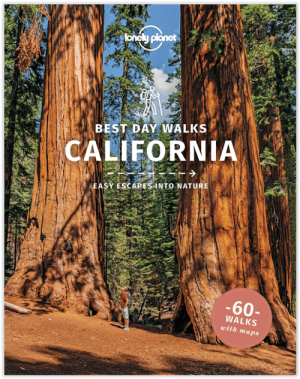
Wandelgids Best Day Walks California - Lonely Planet • 9781838691172
Best Day Walks California - Lonely Planet Productomschrijving: Lonely Planet's Best Day Walks Californië is uw paspoort met 60 gemakkelijke wandel ontsnappingen in de natuur. Strek je benen weg van de stad door een wandeling te kiezen die bij je past, van een paar uur tot een hele dag, van gemakkelijk tot zwaar. Verken Yosemite National Park, bewonder de sequoia's en wandel door Gold Count…
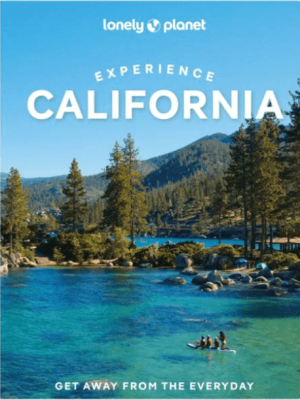
Reisgids Experience California - Lonely Planet • 9781838697440
Lonely Planet Experience California Productomschrijving: Inside Lonely Planet's Experience California: Unique experiences to string together an unforgettable trip Inspiring full-color travel photography and maps throughout Highlights and trip builders to help tailor a trip to your personal needs and interests Fresh perspectives to surprise you with things you hadn't thought…