

HOOFDCATEGORIEËN
Activiteiten
De beroemdste Eilandengroepen
Iconische Bergketens van Europa
AONB - Area of Outstanding Beauty/National Landscape
TOPO's & Stafkaarten
Nationale parken
Regionale parken
UNESCO werelderfgoed
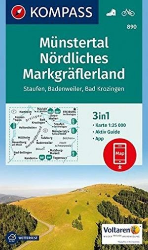
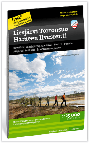
Waterafstotende kaart
Grote Eilanden
Continent
Land
Regio
Reeks/Serie:
Uitgever


Ordnance Survey
Ordnance Survey, Topografische Perfectie van de Britse Eilanden!
Ordnance Survey is het nationale cartografische agentschap van het Verenigd Koninkrijk en wordt wereldwijd erkend als een toonaangevende uitgever van Topografische kaarten. Met een geschiedenis die teruggaat tot 1791, biedt Ordnance Survey kaarten van ongeëvenaarde nauwkeurigheid en kwaliteit. Hun kaarten zijn essentieel voor wandelaars, fietsers en outdoorliefhebbers die het Britse landschap willen verkennen.
De kaarten van Ordnance Survey bestrijken het volledige Verenigd Koninkrijk en bieden een uitzonderlijk detailniveau. Ze zijn ontworpen met een focus op topografie en bevatten essentiële informatie zoals hoogtelijnen, terreincontouren, wandelpaden, natuurlijke kenmerken en culturele bezienswaardigheden. De precisie en betrouwbaarheid van OS-kaarten maken ze een favoriet bij zowel recreatieve als professionele gebruikers.
Ordnance Survey biedt verschillende reeksen kaarten die zijn afgestemd op specifieke behoeften. De Explorer-reeks, met een schaal van 1:25.000, is ideaal voor wandelaars en biedt een ongekend detailniveau, inclusief lokale paden en markante punten. De Landranger-reeks, op een schaal van 1:50.000, biedt een breder overzicht, geschikt voor langeafstandswandelingen en routeplanning. Voor digitale gebruikers biedt OS ook een scala aan interactieve kaarten en apps die toegang bieden tot actuele en gedetailleerde kaartinformatie.
Naast traditionele papieren kaarten staat Ordnance Survey bekend om hun innovatieve gebruik van technologie, zoals GPS-compatibiliteit en digitale overlays. Deze combinatie van traditie en innovatie maakt Ordnance Survey dé betrouwbare partner voor iedereen die het gevarieerde en indrukwekkende Britse landschap wil ontdekken. Met Ordnance Survey navigeren avonturiers met vertrouwen en precisie.


Stadsplattegrond Wandelkaart Edinburg walk - Urban maps - OS • 9780319091906
Stadskaart & wandelkaart Edinburg walk - Urban maps - OS Productomschrijving: Een zigzag gevouwde wandel & Stadskaart van de Schotse stad Edinburgh, met alle bezienswaardigheden die de stad te bieden heeft, zijn parken en zichten van de meest bijzondere plaatsen. Engelse omschrijving: This OS Urban Map will help you discover Edinburgh, including Edinburgh Castle, The Royal Mile, Princ…

Wandelkaart OL11 Brighton- Hove & South Downs NP - OS • 9780319263891
Wandelkaart Brighton- Hove & South Downs NP - OS Productomschrijving: Parts of The South Downs National Park - Lewes - Burgess Hill. Omvat: Brighton, Hove, Portslade, Shoreham by Sea, Peacehaven and Newhaven on the way, the rolling Sussex Downs & parts of the South Downs Way. Ontdek de OL-serie van Ordnance Survey: De OL-serie (Outdoor Leisure) van Ordnance Survey is dé referenti…

Wandelkaart OL22 New Forest National Park - OS • 9780319263921
Wandelkaart New Forest National Park - OS Productomschrijving: New Forest National Park, Hampshire England. Omvat: Southampton, Ringwood, Ferndown, Lymington, Christchurch and Bournemouth, parts of the New Forest National Park. Ontdek de OL-serie van Ordnance Survey: De OL-serie (Outdoor Leisure) van Ordnance Survey is dé referentie voor wie gaat wandelen op de Britse eilanden. D…

Stadsplattegrond Wandelkaart London walk - Urban maps - OS • 9780319091944
Stadskaart Wandelkaart London walk - OS Productomschrijving: Een zigzag gevouwde wandel & Stadskaart van de Engelse hoofdstad London, met alle bezienswaardigheden die de stad te bieden heeft, zijn parken en zichten van de meest bijzondere plaatsen. Ook is er de Thames path inbegrepen op de keerzijde van de kaart. Engelse omschrijving: This brand new OS Urban Map will help you discover …

Wandelkaart OL05 English Lakes - North Eastern area - OS • 9780319264003
Wandelkaart English Lakes - North Eastern area - OS Productomschrijving: Een topografische wandelkaart van het noordoostelijke deel van de Lake District National park. Omvat: English Lakes - North Eastern area, Penrith, Patterdale & Caldbeck, Parts of the Lake District, and The Cumbria Way. Ontdek de OL-serie van Ordnance Survey: De OL-serie (Outdoor Leisure) van Ordnance Survey …
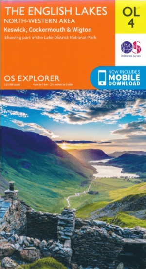
Wandelkaart OL04 English Lakes - North Western area - OS • 9780319263990
Wandelkaart English Lakes - North Western area - OS Productomschrijving: Een toppografische wandelkaart van het noordwestelijke deel van het Lake district. Omvat: Keswick, Cockermouth & Wigton, parts of the Lake District National Park. Also showing the Englisch coast patc and the Cumbria Way. Ontdek de OL-serie van Ordnance Survey: De OL-serie (Outdoor Leisure) van Ordnance Surv…

Wandelkaart OL06 English Lakes - South Western area - OS • 9780319264010
Wandelkaart English Lakes - South Western area - OS Productomschrijving: Een topografische wandelkaart van het Zuid-westelijke deel van het Lake district National Park Omvat: Coniston, Ulverston & Barrow-in-Furness, Part of the Lake District National Park & The Cumbria Way. Ontdek de OL-serie van Ordnance Survey: De OL-serie (Outdoor Leisure) van Ordnance Survey is dé referentie …
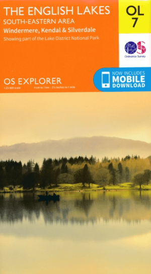
Wandelkaart OL07 English Lakes - South Eastern area - OS • 9780319264027
Wandelkaart English Lakes - South Eastern area - OS Productomschrijving: Een topografische wandelkaart van het Zuid-Oostelijke gedeelte van het Lake District National Park, & the Cumbria Way. Omvat: Windermere, Kendal & Silverdale, the South-Eastern part of the Lake District National Park, The Cumbria Way, Dales Way, Lancashire Coastal Way & Lune Valley Ramble. Ontdek de OL-serie v…

Wandelkaart OL28 Dartmoor National Park - OS • 9780319264034
Wandelkaart Dartmoor National Park - OS Productomschrijving: Dartmoor National Park, Devon England. Ontdek de OL-serie van Ordnance Survey: De OL-serie (Outdoor Leisure) van Ordnance Survey is dé referentie voor wie gaat wandelen op de Britse eilanden. Deze topografische kaarten maken deel uit van de Explorer-reeks en bieden ongeëvenaarde nauwkeurigheid en detail op een schaal van 1:…

Wandelgids Epic British Walks - Ordnance Survey • 9780319092064
Wandelgids Epic British Walks - Ordnance Survey Productomschrijving: OS Epic British Walks allows the reader to take their walking dreams one step further with this inspiring introduction to distance walking and with thirty-eight amazing trails of immense diversity, each graded by difficulty, there are routes for first-time hikers as well as for the super-fit, seasoned multi-day rambler. …

Wandelgids Outstanding Walks Scotland - Ordnance Survey • 9780319092842
Wandelgids Outstanding Walks Scotland - OS Productomschrijving: A treasure trove of walks and days out, Outstanding Walks Scotland brings together a carefully curated selection of 60 walks, 48 ‘don’t miss’ sites and 42 picture essay locations, in total including more than 300 inspirational features of interest for you to visit. Enjoy this lavishly-illustrated volume in the comfort of …

Wandelgids 001 Pathfinder guides South Devon & Dartmoor NP - OS • 9780319090084
Wandelgids South Devon & Dartmoor NP - OS Productomschrijving: Each of the Pathfinder titles features 28 circular routes, all tried and tested by seasoned walkers. The routes range from extended strolls to exhilarating hikes, so there is something for everyone. 28 circular walks • Graded by length ranging from 3 to 12 miles • Clear, large scale Ordnance Survey maps • GPS referen…

Wandelgids 012 Pathfinder New Forest & South Downs NP Hampshire • 9780319090107
Wandelgids New Forest & South Downs NP Hampshire - OS Productomschrijving: This Pathfinder walking guidebook covers the New Forest National Park, Hampshire and the South Downs National Park, including the Itchen and Test valleys. There are 28 outstanding circular walks in the Hampshire countryside ranging from two to ten miles in length, and graded by difficulty by expert outdoor writer D…
Wandelgids 018 Pathfinder guides Brecon Beacons Wales - OS • 9780319090015
Wandelgids Brecon Beacons Wales - OS Productomschrijving: With 28 circular, graded walks all tried and tested by seasoned walkers, this walking guidebook is ideal for both visitors and locals. The routes range from extended strolls to exhilarating hikes, so there is something for everyone. Each route includes a detailed description, the Ordnance Survey map for the route, GPS waypoints and…

Wandelgids 025 Pathfinder guides Thames Valley & Chilterns - OS • 9780319090053
Wandelgids The Thames Valley & The Chilterns AONB Productomschrijving: The Chilterns AONB form part of the long line of chalk hills stretching intermittently across southern and eastern England. It is an area characterised by beech woods and dry valleys, and these natural features are explored in the 28 routes available in this walks guidebook. The Thames Valley is steeped in history,…

Wandelgids 054 Pathfinder guides Hertfordshire & Bedfordshire- OS • 9780319090077
Wandelgids Hertfordshire & Bedfordshire - OS Productomschrijving: This walkers guide contains 28 outstanding circular walks in Hertfordshire and Bedfordshire ranging from 5.5km to 15km. Each route has easy-to-follow route descriptions, clear Ordnance Survey route maps, GPS waypoints, where to park, good pubs and places of interest en route. All of the routes have been researched and writt…

Wandelgids 064 Pathfinder guides South Pennines - OS • 9780319090046
Wandelgids South Pennines - OS Productomschrijving: This book gives details of 28 amazing walks across the Pennines (Lancashire and Yorkshire), including South Pennines’ most famous viewpoint at Stoodley Pike and the parts of the Pennine Way. Each of the routes has information on local amenities, a detailed route description, and extract of the large-scale OS Map for the area and notes an…

Wandelgids 045 Pathfinder guides Norfolk - OS • 9780319090152
Wandelgids Norfolk East England - OS Productomschrijving: These 28 circular, graded walks around Norfolk are all tried and tested by seasoned walkers. The routes range from extended strolls of four miles to exhilarating hikes of eleven, so there is something for everyone. Each route includes information on parking and local amenities, detailed route description, a large-scale OS map a…

Wandelgids 010 Pathfinder guides Snowdonia NP Wales - OS • 9780319090145
Wandelgids Snowdonia National Park - OS Productomschrijving: Rather than just following the crowds up to Snowdon's peak , you can discover far more of this beautiful and varied region with this collection of 28 carefully selected walks, ranging from three to twelve miles long. Each walk includes introductory information, route directions, an extract of the Ordnance Survey map and not…

Wandelgids 060 Pathfinder guides Lake District NP - OS • 9780319090169
Wandelgids Lake District NP - OS Productomschrijving: The Pathfinder Guide for the Lake District NP is the ideal companion to gaining an appreciation of England's most mountainous region with its balanced range of walks across the whole of the National Park. There are a total of 28 outstanding circular walks in the Lake District National Park from 3 to 10 miles with easy-to-follow route de…

Wandelgids 009 Pathfinder guides Exmoor NP & the Quantocks - OS • 9780319090114
Wandelgids Exmoor National Park & the Quantocks - OS Productomschrijving: Exmoor National Park comprises 265 square miles, of which about two-thirds lie in west Somerset and the remaining third in north Devon. This walking guidebook contains 28 circular, graded walks in Exmoor, all tried and tested by seasoned walkers. The routes range from extended strolls to longer hikes, so there is som…

Wandelgids 023 Pathfinder guides Loch Lomond, Trossachs NP - OS • 9780319090190
Wandelgids Loch Lomond, Trossachs NP & Stirling - OS Productomschrijving: The Pathfinder guidebook for Loch Lomond, The Trossach and Stirling includes 28 circular, graded walks all tried and tested by seasoned walkers. The routes range from two mile strolls to sixteen mile hikes, so there is something for everyone. Each route includes a detailed description, large-scale Ordnance Survey ma…

Wandelgids 008 Pathfinder guides Kent - OS • 9780319090183
Wandelgids Kent South-East England - OS Productomschrijving: This walking guidebook for Kent has 28 great walks exploring coastal and inland Kent, including the Isle of Sheppey. Kent contains a wealth of history from Roman times to modern day, with many of the key sites visited on these pre-planned walks. Each walk includes easy-to-follow route directions and are accompanied by large-scal…

Wandelgids 028 Pathfinder guides North York Moors NP - OS • 9780319090251
Wandelgids North York Moors National Park - OS Productomschrijving: The Pathfinder guidebook for The North York Moors is designed to help you make the most of your time in the area. It contains 28 walks, each graded by difficulty and ranging from 3.5 miles up to 11 miles in length. All the routes are created by seasoned walkers, and designed to help you make the most of the area. High…
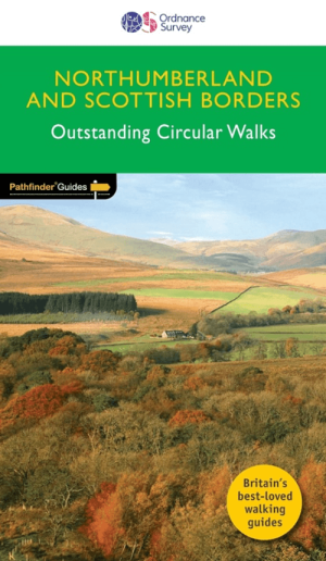
Wandelgids 035 Pathfinder guides Northumberland- Scottish Borders • 9780319090268
Wandelgids Northumberland & Scottish Borders - OS Productomschrijving: This revised version of the Pathfinder walking guidebook for Northumberland and the Scottish Borders contains 28 carefully selected walking routes to help you make the most of the area. All the routes have been created and tested by seasoned walkers, and range from two to thirteen miles in length. Each route include…