

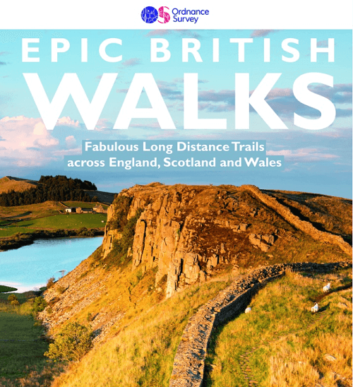
Wandelgids Epic British Walks - Ordnance Survey
38 Epic British Walks through the whole of the UK


Korte omschrijving
Wandelgidsen Engeland, Schotland en Wales van Ordnance Survey. Ideaal voor tochten in England, Schotland en Wales.
Wandelgids Epic British Walks - Ordnance Survey Productomschrijving: OS Epic British Walks allows the reader to take their walking dreams one step further with this inspiring introduction t...

Specificaties
- Uitgever: Ordnance Survey
- ISBN-13: 9780319092064
- HOOFDCATEGORIEËN: Wandelgids
- Activiteiten: Wandelen, Hiking & Trekking
- Auteur: Terry Marsch
- Regio: Engeland, Schotland, Wales
- Land: England, Schotland, Wales
- Taal: Engels
Volledige omschrijving
Wandelgids Epic British Walks - Ordnance Survey
Productomschrijving: OS Epic British Walks allows the reader to take their walking dreams one step further with this inspiring introduction to distance walking and with thirty-eight amazing trails of immense diversity, each graded by difficulty, there are routes for first-time hikers as well as for the super-fit, seasoned multi-day rambler.
This is the perfect book for planning a walking adventure, hiking holiday or weekend ramble. With insightful introductions to each route by best-selling OS Pathfinder Guide author Terry Marsh, all 304 pages are filled with suggested itineraries, the must-see highlights to take in along the way and, of course, the list of Ordnance Survey sheet maps for completing the walks.
Plan the hike of your dreams... from the big skies of Norfolk to the spectacular coastal scenery of Pembrokeshire, and the majesty of the Great Glen Way to the truly ancient thoroughfare of the Ridgeway... 38 Epic British Walks to fulfil your wanderlust.

Artikelen uit dezelfde regio

Landkaart Wegenkaart Engeland & Wales UK - Freytag & Berndt • 9783707924077
Wegenkaart Engeland & Wales UK - Freytag & Berndt Productomschrijving: Deze recto/verso gedetailleerde landkaart van Engeland en Wales is zeer geschikt voor het plannen en voor het rondtrekken door het land. Het wegennetwerk is goed weergeven, zowel de hoofdwegen, de provinciale en lokale wegen. Tevens worden wegnummers duidelijk vermeld. Afstanden tussen plaatsen zijn in kilometers op de…

Wandelgids Best Day Walks Great Britain - Lonely Planet publ. • 9781838692100
Wandelgids Great Britain - Lonely Planet publications Productomschrijving: Lonely Planet's Best Day Walks Great Britain is your passport to 60 easy escapes into nature. Stretch your legs outside the city by picking a hike that works for you, from a few hours to a full day, from easy to hard. Cross misty moors, hike wild landscapes, and explore the highlands. Get to the heart of Great Brita…

Landkaart Wegenkaart 713 Groot-Brittannië & Ierland 26 - Michelin • 9782067270220
Wegenkaart 713 Groot-Brittannië & Ierland 2026 - Michelin Productomschrijving: Deze kaart omvat de nieuwe versie voor 2026, met alle straten, hoofdwegen, toeristische informatie en locaties voor Groot-Brittannië & Ierland 2026 - Nationale kaarten - Wegenkaarten national: een overzicht van het land voor lange trajecten - Schaal aangepast aant het land - Kaarten met jaartal voor de…
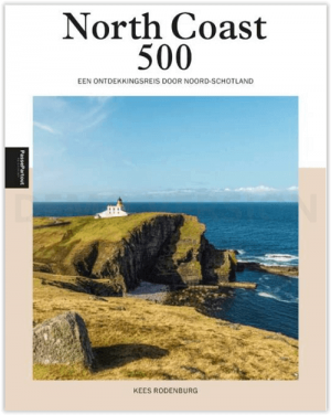
Reisgids North Coast 500 Schotland - Edicola • 9789493201224
North Coast 500 Schotland - Edicola Productomschrijving: Met het lanceren van de North Coast 500 in 2015 werd in één keer Noord-Schotland op de kaart gezet. De ruim 800 km lange route, die start en eindigt in Inverness en grotendeels loopt langs de noord-schotse kusten, omlijst een enorm uitgestrekt gebied waarin talloze uitersten zicht aan de mobiele reiziger opdringen, van kleine pittore…
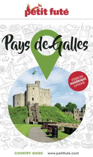
Reisgids Pays de Galles / Wales - Petit futé • 9782305113098
Guide de voiage Pays de Galles - Petit futé Productomschrijving: Si l'on devait faire le portrait du Pays de Galles, on le comparerait volontiers à un petit bout, très occidental, de la France de l'Ouest. Une contrée qui serait un mélange de pays de Retz, avec ses côtes rocheuses, ses petits ports de pêche, ses plages et ses criques, de Normandie, pour ses nombreux vallons verdoyants et hu…