

Landkaart Wegenkaart 3312 Adventure map Duitsland - Nat Geo
Berlin- Munchen...


Korte omschrijving
Wegenkaart Adventure map Duitsland - Nat Geo Productomschrijving: National Geographic's Germany Adventure Map is a highly functional travel tool whether you're exploring the scenic terrain, ...

Specificaties
- Uitgever: National Geographic
- ISBN-13: 9781566956031
- HOOFDCATEGORIEËN: Wegenkaart - Landkaart
- Activiteiten: Street/Road maps & city plans
- Auteur: National Geographic
- Regio: Duitsland
- Land: Duitsland
- Waterafstotende kaart: Nat Geo waterproof series
- TOPO's & Stafkaarten: Topografisch wandelen
- Schaal: 1:825000
- Taal: Engels
- Reeks/Serie: NAT GEO Adventure travel maps
- De Duitse Regio's: Baden-Württemberg, Bayern Duitsland, Berlijn, Bodensee, Duitsland, Brandenburg, Bremen, Hamburg, Hessen, Mecklenburg-Vorpommern, Niedersachen, Nordrhein-Westfalen, Rijnland-Paltz, Saarland, Sachsen, Sachsen-Anhalt, Schleswig-Holstein, Spreewald, Brandenburg Duitsland, Thüringen
Volledige omschrijving
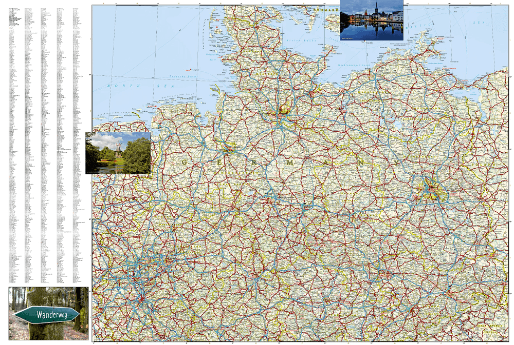
Wegenkaart Adventure map Duitsland - Nat Geo
Productomschrijving: National Geographic's Germany Adventure Map is a highly functional travel tool whether you're exploring the scenic terrain, the many cosmopolitan cities, or the iconic historical sites. Cities and towns are clearly indicated and easy to find in the user-friendly index. A road network complete with distances and designations for roads, motorways, expressways, and secondary routes will help you find the route that's right for you. With specialty content to include hundreds of diverse and unique recreational, ecological, cultural, and historical destinations, this map is a perfect companion to a guidebook. National parks, museums, churches, castles, palaces, and points of interest are clearly indicated as are travel aids such as airports, railroads, and ferry routes.
The front side of the print map details the southern region of the country, from its border with Luxembourg, Belgium and France to the west, to Switzerland and Austria to the south, and Czechoslovakia to the east. The reverse side details Germany's northern region; bordering Belgium and the Netherlands to the west, Poland and Czechoslovakia to the east and the Baltic Sea, Denmark and the North Sea to the north. Whether taking in the vast forests, rivers, and mountains, exploring the rich history, or enjoying the art, nightlife, and beer halls, this map will help you make the most of your time in this intriguing country.
Every Adventure Map is printed on durable synthetic paper, making them waterproof, tear-resistant and tough — capable of withstanding the rigors of international travel.
Overzichtskaarten

NAT GEO Adventure maps EUROPE 3302 - 3328
NAT GEO Adventure maps EUROPE 3302 - 3328
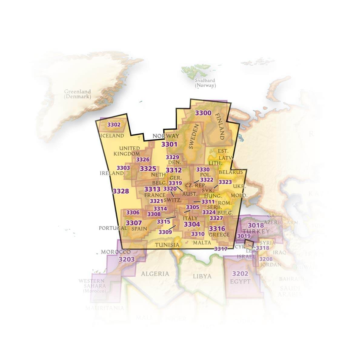
Producten op de overzichtskaart
Klik op een product om naar de detailpagina te gaan.
- Landkaart Wegenkaart 3301 Zweden Zuid & Noorwegen - Nat Geo
- Landkaart Wegenkaart 3302 Ijsland - Nat Geo
- Landkaart Wegenkaart 3303 Ierland - Nat Geo
- Landkaart Wegenkaart 3304 Italië - Nat Geo
- Landkaart Wegenkaart 3305 Toscane - Nat Geo
- Landkaart Wegenkaart 3306 Spanje Noord - Nat Geo
- Landkaart Wegenkaart 3307 Spanje & Portugal - Nat Geo
- Landkaart Wegenkaart 3308 Pyreneeën & Andorra - Nat Geo
- Landkaart Wegenkaart 3309 Sardinië - Nat Geo
- Landkaart Wegenkaart 3312 Adventure map Duitsland - Nat Geo
- Landkaart Wegenkaart 3313 Adventure map Frankrijk - Nat Geo
- Landkaart Wegenkaart 3314 Adventure map Zuid-Frankrijk - Nat Geo
- Landkaart Wegenkaart 3315 Adventure map Corsica - Nat Geo
- Landkaart Wegenkaart 3316 Adventure map Griekenland - Nat Geo
- Landkaart Wegenkaart 3317 Adventure map Kreta - Nat Geo
- Landkaart Wegenkaart 3318 Adventure map Cyprus - Nat Geo
- Landkaart Wegenkaart 3319 Adventure map Oostenrijk - Nat Geo
- Landkaart Wegenkaart 3320 Adventure map Zwitserland - Nat Geo
- Landkaart Wegenkaart 3321 De Alpen - Nat Geo
- Landkaart Wegenkaart 3322 Adventure map Tsjechië - Nat Geo
- Landkaart Wegenkaart 3323 Adventure map Slowakije - Nat Geo
- Landkaart Wegenkaart 3324 Adventure map Kroatië - Nat Geo
- Landkaart Wegenkaart 3325 Adventue map Groot-Brittannië - Nat Geo
- Landkaart Wegenkaart 3326 Adventure map Schotland - Nat Geo
- Landkaart Wegenkaart 3327 Westelijke Balkan - Nat Geo
- Landkaart Wegenkaart 3328 Europa - Nat Geo
Artikelen uit dezelfde regio
Landkaart Wegenkaart Duitsland (Franstalig) - Expressmap • 9788381906005
Wegenkaart Duitsland (Franstalig) - Expressmap Productomschrijving: ExpressMap is de uitgever van comfort! maps, geplastificeerde kaarten die eenvoudig te vouwen zijn, zelfs met één hand. Een uniek en innovatief product. Comfortabel, waterbestand, onverscheurbaar, comfort! maps blijven hun kwaliteit lang behouden. Duurzame kaarten, nuttig om een uitstap te plannen en handig voor onderweg. …

Wegenkaart Duitsland Compleet - Kümmerly & Fry • 9783259018514
Wegenkaart Duitsland Compleet - Kümmerly & Fry Productomschrijving: Op zoek naar betrouwbare Hallwag wegenkaart van Duitsland? Deze klassieke road maps staan bekend om hun duidelijke cartografie, praktische indeling en heldere weergave van wegen en verbindingen. Voor autoritten, vakanties, camperreizen en lange roadtrips bieden Hallwag wegenkaarten het overzicht dat je onderweg nodig hebt.…
Landkaart Wegenkaart Duitsland Noord & Zuid - Kümmerly & Fry • 9783259300442
Wegenkaart Duitsland Noord & Zuid - Kümmerly & Fry Productomschrijving: Op zoek naar betrouwbare Kümmerly & Fry wegenkaart? Deze klassieke road maps staan bekend om hun duidelijke cartografie, praktische indeling en heldere weergave van wegen en verbindingen. Voor autoritten, vakanties, camperreizen en lange roadtrips bieden Hallwag wegenkaarten het overzicht dat je onderweg nodig hebt. …

Spoorwegenkaart Duitsland - Freytag & Berndt • 9783707924237
Rail travel Map Duitsland - Freytag & Berndt Productomschrijving: Duitsland Spoorwegkaart f&b 1:500 000 - De spoorwegkaart van Duitsland van Freytag & Berndt is ontwikkeld voor spoorwegliefhebbers, treinspotters en Interrail-reizigers. - Schaal 1:500.000 - Hogesnelheidslijnen - Hoofd- en zijlijnen - Toeristische spoorwegen - Goederenvervoer - Formaat: ca. 133,5 x 96 cm, dub…

Kampeergids Charmecampings Duitsland - ANWB • 9789018033187
Charmecampings Duitsland - ANWB Productomschrijving: Deze versie heeft "streng" geselecteerde campings, volledig in kleur, met ruim 400 foto's, uitvoerige beschrijvingen, om u een degelijke indruk te geven, van hoe het er is ter plaatse. Elke individuele camping werd door experts bezocht en gekeurd alvorens toegevoegd aan deze gids.