

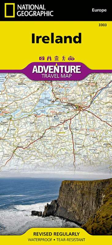
Landkaart Wegenkaart 3303 Ierland - Nat Geo
Limerick- Tralee- Cork- Waterford- Dublin- Galway
Korte omschrijving
Wegenkaart Ierland - Nat Geo Productomschrijving: Explore the storied "Emerald Isle" with National Geographic's Ireland Adventure Map. Designed to meet the needs of adventure travelers with...

Specificaties
- Uitgever: National Geographic
- ISBN-13: 9781566955355
- HOOFDCATEGORIEËN: Wegenkaart - Landkaart
- Activiteiten: Street/Road maps & city plans
- Auteur: National Geographic
- Regio: Ierland
- Land: Ierland
- Waterafstotende kaart: Nat Geo waterproof series
- TOPO's & Stafkaarten: Topografisch wandelen
- Schaal: 1:385000
- Taal: Engels
- Reeks/Serie: NAT GEO Adventure travel maps
Volledige omschrijving
Wegenkaart Ierland - Nat Geo
Productomschrijving: Explore the storied "Emerald Isle" with National Geographic's Ireland Adventure Map. Designed to meet the needs of adventure travelers with its detailed, accurate information, this map includes the location of cities and towns with a user-friendly index and a clearly marked road network complete with distances and designations for roads/highways, plus secondary routes for those seeking to explore off the beaten path. Specialty content such as hundreds of diverse and unique recreational, ecological, cultural, and historical destinations make Adventure Maps the perfect companion to a guidebook.
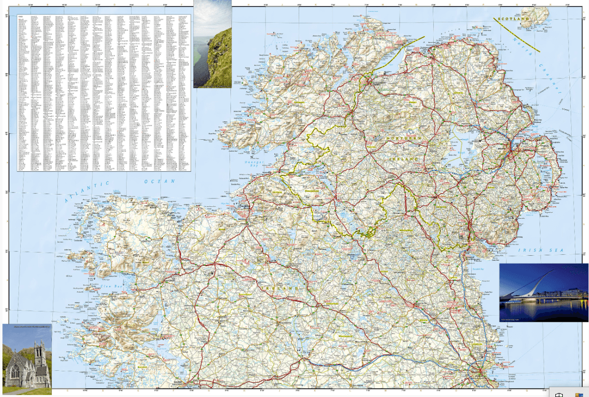
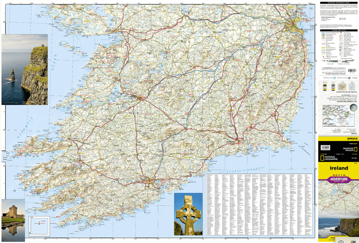
The Ireland Adventure Map covers the entire island including the Republic of Ireland and British-ruled Northern Ireland in one easy-to-use map. The north side of the map details from the northernmost tip of the island at Malin Head south to Dublin and Galway, including Belfast, Dundalk, Londonderry, and Sligo. The south side overlaps the northern side of the map at Galway on the west and Dublin on east, covering the remainder of the country including the cities of Limerick, Tralee, Cork, and Waterford.
Ireland's lush green landscape is a result of its temperate, oceanic climate. The island's geography is mostly comprised of a central plain surrounded by relatively low-lying mountains. Coastal regions vary from sandy beaches to towering cliffs that rise hundreds of feet above the pounding surf. Castles, churches, abbeys, monasteries, and Neolithic sites abound, offering travelers a remarkable variety of opportunities to explore Ireland's rich and ancient cultural history.
Every Adventure Map is printed on durable synthetic paper, making them waterproof, tear-resistant and tough — capable of withstanding the rigors of international travel.
Overzichtskaarten

NAT GEO Adventure maps EUROPE 3302 - 3328
NAT GEO Adventure maps EUROPE 3302 - 3328
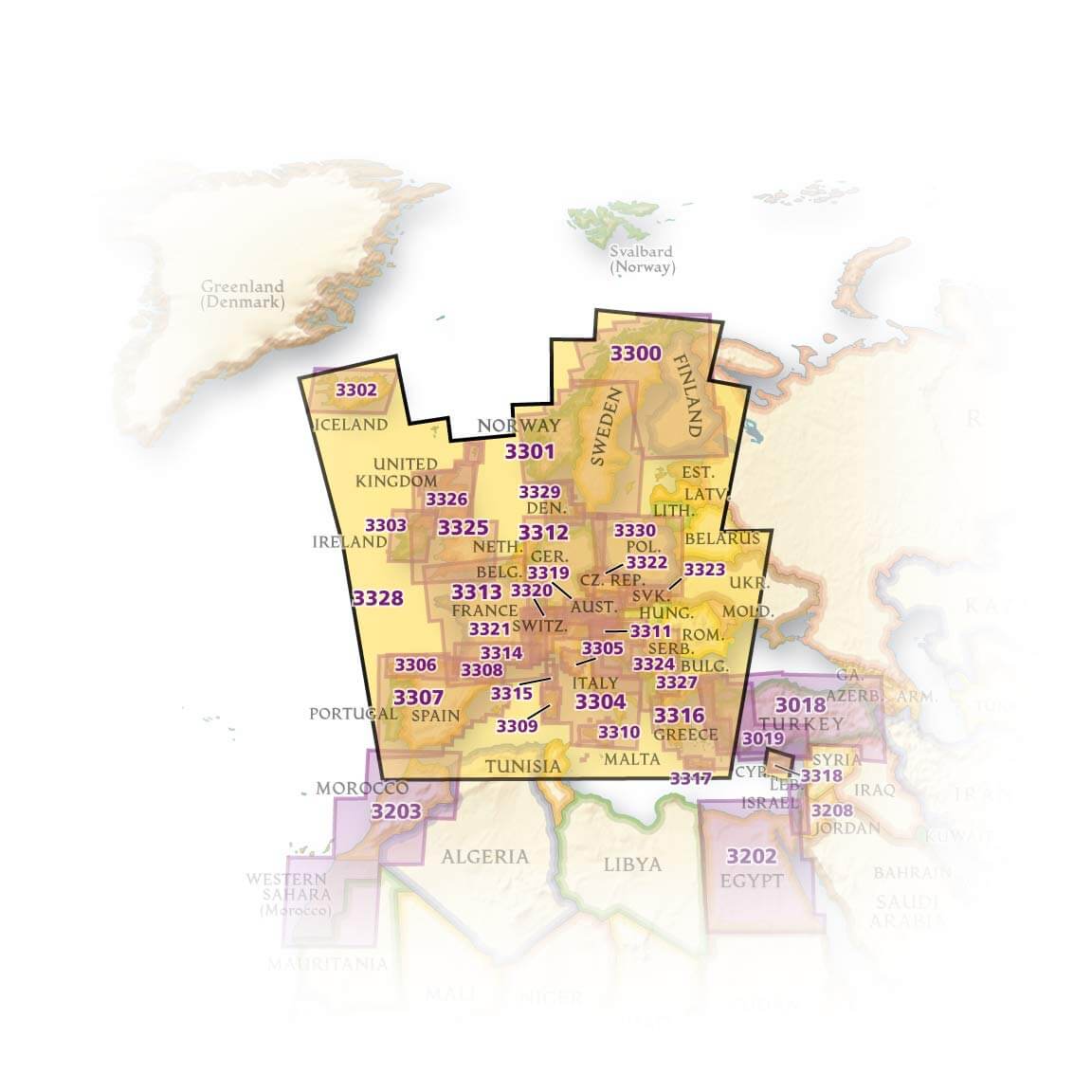
Producten op de overzichtskaart
Klik op een product om naar de detailpagina te gaan.
- Landkaart Wegenkaart 3301 Zweden Zuid & Noorwegen - Nat Geo
- Landkaart Wegenkaart 3302 Ijsland - Nat Geo
- Landkaart Wegenkaart 3303 Ierland - Nat Geo
- Landkaart Wegenkaart 3304 Italië - Nat Geo
- Landkaart Wegenkaart 3305 Toscane - Nat Geo
- Landkaart Wegenkaart 3306 Spanje Noord - Nat Geo
- Landkaart Wegenkaart 3307 Spanje & Portugal - Nat Geo
- Landkaart Wegenkaart 3308 Pyreneeën & Andorra - Nat Geo
- Landkaart Wegenkaart 3309 Sardinië - Nat Geo
- Landkaart Wegenkaart 3312 Adventure map Duitsland - Nat Geo
- Landkaart Wegenkaart 3313 Adventure map Frankrijk - Nat Geo
- Landkaart Wegenkaart 3314 Adventure map Zuid-Frankrijk - Nat Geo
- Landkaart Wegenkaart 3315 Adventure map Corsica - Nat Geo
- Landkaart Wegenkaart 3316 Adventure map Griekenland - Nat Geo
- Landkaart Wegenkaart 3317 Adventure map Kreta - Nat Geo
- Landkaart Wegenkaart 3318 Adventure map Cyprus - Nat Geo
- Landkaart Wegenkaart 3319 Adventure map Oostenrijk - Nat Geo
- Landkaart Wegenkaart 3320 Adventure map Zwitserland - Nat Geo
- Landkaart Wegenkaart 3321 De Alpen - Nat Geo
- Landkaart Wegenkaart 3322 Adventure map Tsjechië - Nat Geo
- Landkaart Wegenkaart 3323 Adventure map Slowakije - Nat Geo
- Landkaart Wegenkaart 3324 Adventure map Kroatië - Nat Geo
- Landkaart Wegenkaart 3325 Adventue map Groot-Brittannië - Nat Geo
- Landkaart Wegenkaart 3326 Adventure map Schotland - Nat Geo
- Landkaart Wegenkaart 3327 Westelijke Balkan - Nat Geo
- Landkaart Wegenkaart 3328 Europa - Nat Geo
Artikelen uit dezelfde regio
Reisgids Insight Guides Ireland ENG - APA publucations • 9781839054617
Reisgids Insight Guides Ireland ENG - APA publucations Productomschrijving: From deciding when to go, to choosing what to see when you arrive, Insight Guide Ireland, is all you need to plan your trip and experience the best of Ireland, with in-depth insider information on must-see, top attractions like Dublin, the Giant's Causeway, the Aran Islands, Connemara and the Wild Atlantic Way, and…
Landkaart Wegenkaart H2 Ierland West - OSI • 9781908852878
Wegenkaart West Ierland - OSI Productomschrijving: Wegenkaart West Ierland - OSI - Ordnance Survey Ireland West Road map at 1:250,000 approx 4 miles to the Inch. This map shows detailed road classification, altitude colouring and tourist information, published by OSI, the Ordnance Survey of Ireland. Topography of the island is shown by altitude colouring, with additional spot …

Wandelingen Ierland - 50 wandelingen met GPS - Elmar Uitgeverij • 9789038929316
Wandelingen Ierland - Elmar Uitgeverij Productomschrijving: De Rother wandelgids Ierland bevat 50 prachtige wandelingen langs de kust en in de bergen van deze wonderschone wandelbestemming. Zoals gebruikelijk zijn er verschillende wandelingen voor beginnende en ervaren wandelaars en is er onmisbare informatie over de streek, de bezienswaardigheden en recreatiemogelijkheden. De betrouwb…

Fietsgids Great British Bike Rides - Vertebrate Publ. • 9781906148553
Great British Bike Rides - Vertebrate Productomschrijving: 40 classic routes for road cyclists Great British Bike Rides by Dave Barter brings together 40 of the best road rides in England, Scotland and Wales, searching out the country's most celebrated routes, toughest climbs and scenic roads. Features detailed route information, bespoke mapping and a statistical breakdown of every det…

Stadsplattegrond Belfast pocket map - Harper Collins • 9780008716530
Stadskaart Belfast pocket map - Harper Collins Productomschrijving: Handy little full color Collins map of central Belfast with a high level of detail. Clear mapping from Cliftonville in the north to Botanics in the south, and Shankill in the west to City Airport in the east. Map at a scale of 1:10,000 (6 inches to 1 mile). Clear, detailed, full color Collins mapping is presented in a han…