

Wandelkaart 330 Moffat & St Mary's Loch - Dumfries - OSI
Moffat- St. Mary's Loch & Megget Reservoir te Schotland
Korte omschrijving
Wandelkaarten Dumfries & Galloway, Schotland van Ordnance Survey. Ideaal voor tochten in Schotland.
Wandelkaart Moffat & St Mary's Loch - Schotland Omvat ook: Megget Reservoir Productomschrijving: Omvat Moffat in Dumfries and Galloway, Schotland. OS Explorer kaart 330 omvat ook St. Ma...

Specificaties
- Uitgever: Ordnance Survey
- ISBN-13: 9780319245828
- HOOFDCATEGORIEËN: Wandelkaart
- Activiteiten: Wandelen, Hiking & Trekking
- Regio: Dumfries & Galloway, Schotland
- Land: Schotland
- TOPO's & Stafkaarten: Topografisch wandelen
- Schaal: 1:25000
- Taal: Engels
- Reeks/Serie: Explorer Series OS
Volledige omschrijving
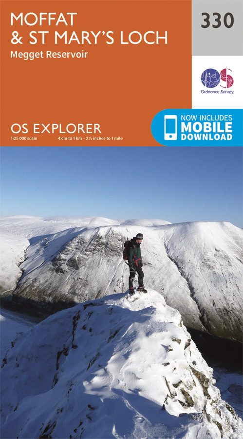
Wandelkaart Moffat & St Mary's Loch - Schotland
Omvat ook: Megget Reservoir
Productomschrijving: Omvat Moffat in Dumfries and Galloway, Schotland. OS Explorer kaart 330 omvat ook St. Mary's Loch, Megget Reservoir en deel van de Southern Upland Way, een lange afstand wandelroute. De OS Explorer kaart voor Moffat & St Mary's Loch is beschikbaar in zowel de standaard papieren versie als de weerbestendige 'Actief' versie.
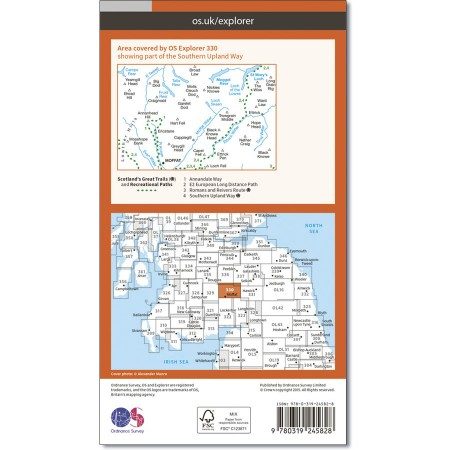
Kaart nummer 330 is een all purpose kaart vol gepakt met informatie om u het gebied te helpen leren kennen. De kaarten bestrijken het land. Elke kaart heeft een oppervlakte van 40 km door 40 km (25 mijl door 25 mijl) en zoals andere kaarten van Ordnance Survey, National Grid-vierkanten worden verstrekt zodat elke functie een unieke referentienummer kan worden gegeven.
Productdiscription: Covering Moffat in Dumfries and Galloway, Scotland, OS Explorer map 330 also shows St Mary's Loch, Megget Reservoir and part of the Southern Upland Way Long Distance Route. The OS Explorer map for Moffat & St Mary’s Loch is available in both the standard paper version and weatherproof 'Active' version.
Locatie op kaart
Gekoppelde artikelen
Wandelkaart 330 Moffat & St Mary's Loch - Dumfries - OSI • 9780319245828
standaard versieWandelkaart Moffat & St Mary's Loch - Schotland Omvat ook: Megget Reservoir Productomschrijving: Omvat Moffat in Dumfries and Galloway, Schotland. OS Explorer kaart 330 omvat ook St. Mary's Loch, Megget Reservoir en deel van de Southern Upland Way, een lange afstand wandelroute. De OS Explorer kaart voor Moffat & St Mary's Loch is beschikbaar in zowel de standaard papieren versie als …
Wandelkaart 330 Moffat & St Mary's Loch Schotland - OSI • 9780319472026
weatherproof versieWandelkaart Moffat & St Mary's Loch - Schotland Omvat ook: Megget Reservoir. Productbeschrijving: OS Explorer kaart nummer 330 toont St. Mary's Loch, Megget, die betrekking heeft op Moffat in Dumfries and Galloway, de Reservoir en deel van de Southern Upland Way lange afstand wandelroute. De OS Explorer kaart voor Moffat & St Mary's Loch is beschikbaar in zowel de standaard papieren ve…
Overzichtskaarten
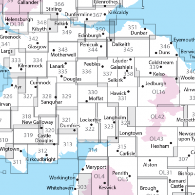
OSI Explorer & Explorer Active - Zuid Scotisch Borders
OSI Explorer & Explorer Active - Zuid Scotisch Borders

Producten op de overzichtskaart
Klik op een product om naar de detailpagina te gaan.
- Wandelkaart 307 Consett & Derwent reservoir - OSI
- Wandelkaart 308 Durham & Sunderland - England - OSI
- Wandelkaart 309 Stranraer & The Rhins - Dumfries - OSI
- Wandelkaart 310 Glenluce & Kirkcowan - Schotland - OSI
- Wandelkaart 311 Wigtown- Whithorn & The Machars - OSI
- Wandelkaart 312 Kirkcudbright & Castle Douglas - OSI
- Wandelkaart 313 Dumfries & Dalbeattie- Schotland - OSI
- Wandelkaart 314 Solway Firth- Wigton & Silloth - OSI
- Wandelkaart 315 Carlisle- Brampton & Longtown - OSI
- Wandelkaart 316 Newcastle upon Tyne - Northumberland - OSI
- Wandelkaart 318 Galloway Forest Park North- Ayrshire
- Wandelkaart 319 Galloway Forest Park South - OSI
- Wandelkaart 320 Castle Douglas & Loch Ken - OSI
- Wandelkaart 321 Nithsdale & Dumfries & Thornhill - OSI
- Wandelkaart 322 Annandale- Dumfries & Galoway - OSI
- Wandelkaart 323 Eskdale & Castle O'er Forest- Schotland - OSI
- Wandelkaart 324 Liddesdale & Kershope Forest - OSI
- Wandelkaart 325 Morpeth & Blyth - Northumberland - OSI
- Wandelkaart 326 Ayr & Troon - South Ayrshire - OSI
- Wandelkaart 327 Cumnock & Dalmellington - OSI
- Wandelkaart 328 Sanquhar & New Cumnock - OSI
- Wandelkaart 329 Lowther Hills- Sanquhar & Leadhills - OSI
- Wandelkaart 330 Moffat & St Mary's Loch - Dumfries - OSI
- Wandelkaart 331 Teviotdale South - Schotisch Borders - OSI
- Wandelkaart 332 Alnwick Amble - Northumberland - OSI
- Wandelkaart 333 Kilmarnock & Irvine - East Ayrshire - OSI
- Wandelkaart 334 East Kilbride- Galston & Darvel - Glasgow - OSI
- Wandelkaart 335 Lanark & Tinto Hills - South Lankashire - OSI
- Wandelkaart 336 Biggar & Broughton - South Lanarkshire - OSI
- Wandelkaart 337 Peebles & Interleithen - Schotish Borders - OSI
- Wandelkaart 338 Galashiels- Selkirk & Melrose - OSI
- Wandelkaart 339 Kelso- Coldstream & Lower Tweed Valley - OSI
- Wandelkaart 340 Holy Island & Bamburgh - OSO
- Wandelkaart 341 Greenock- Largs & Millport - OSI
- Wandelkaart 342 Glasgow Schotland - OSI
- Wandelkaart 343 Motherwell & Coatbridge- Glasgow - OSI
- Wandelkaart 344 Pentland Hills RP- Edinburgh - OSI
- Wandelkaart 345 Lammermuir Hills - Edinburgh - OSI
- Wandelkaart 346 Berwick-upon-Tweed - Northumberland - OSI
- Wandelkaart 349 Falkirk- Cumbernauld & Livingston - OSI
- Wandelkaart 350 Edinburgh - East Schotland - OSI
- Wandelkaart 351 Dunbar & North Berwick - Edinburgh - OSI
- Wandelkaart 361 Isle of Arran - OSI
- Wandelkaart 362 Cowal West & Isle of Bute - OSI
- Wandelkaart OL04 English Lakes - North Western area - OS
- Wandelkaart OL05 English Lakes - North Eastern area - OS
- Wandelkaart OL16 Cheviot Hills, Jedburgh & Wooler - OS
- Wandelkaart OL37 Cowal East- Dunoon & Iverary - OS
- Wandelkaart OL38 Loch Lomond South & Dumbarton - OSI
- Wandelkaart OL42 Kielder Water & Forest - OS
- Wandelkaart OL43 Hadrian's Wall- Haltwhistle & Hexham - OS
Artikelen uit dezelfde regio

Wandelkaart Galloway Hills XT40 ultra - Harvey Maps • 9781851377282
Wandelkaart Galloway Hills - Harvey Maps Productomschrijving: De Galloway Hills zijn een reeks heuvels in de Schotse regio Dumfries and Galloway. Ze liggen in het zuidwesten van Galloway. De Galloway Hills bestaan uit de bergen Merrick, Criffel & Cairnsmore of Fleet.

Reisgids Go Slow Dumfries & Galloway - Bradt travel guides • 9781804692721
Reisgids Dumfries & Galloway - Bradt Productomschrijving: Written by Southern Scotland experts, this new, thoroughly updated third edition of Bradt's Dumfries & Galloway (Slow Travel) remains the only full-blown guide to this beguiling southwest corner of Scotland. The region is covered in depth, from Eskdale in the east to Scotland's southern tip at the Mull of Galloway, via Annandal…

Wandelkaart 321 Nithsdale & Dumfries & Thornhill - OSI • 9780319245736
Wandelkaart Nithsdale & Dumfries - Thornhill Dumfries Omvat ook: Thornhill Productomschrijving: OS Explorer kaart 321 omvat Dumfries te Thornhill. Het gebied staat bekend als Nithsdale, want het is de vallei van de rivier de Nith. De indrukwekkende Drumlanrig Castle is het hele jaar geopend, of er zijn wandelpaden over het Nithsdale gebied. De OS Explorer kaart voor Nithsdale & Dumfrie…
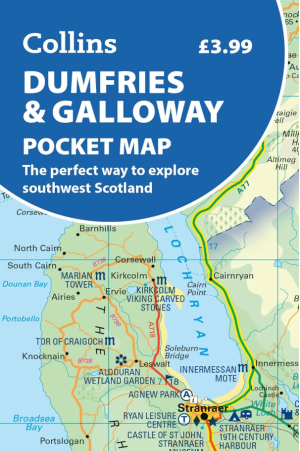
Landkaart Wegenkaart Pocket map Dumfries & Galloway - Harper • 9780008780449
Wegenkaart Pocket map Dumfries & Galloway - Harper Collins Productomschrijving: Dumfries & Galloway Pocket Map: The perfect way to explore southwest Scotland Map Handy little full colour map of Dumfries & Galloway.
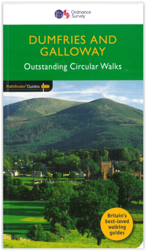
Wandelgids 019 Pathfinder guides Dumfries & Galloway - OS • 9780319091180
Wandelgids Dumfries & Galloway Schotland - OS Productomschrijving: Dumfries and Galloway form the South-west of Scotland, a broad wedge of land jutting out into the Irish Sea between the Solway Firth and the Firth of Clyde. The area is also part of Scotland's border country a peaceful, unspoilt region that possesses a mild climate, a great variety of scenery and a rich historic legacy. …