

Wandelgids King Charles III England Coast Path Map Booklet
Cumbria, from Gretna on the Scottish border to Grange-over-Sands


Korte omschrijving
Wandelgidsen Cumbria & Lake District, England van CICERONE Press. Ideaal voor tochten in England.
Wandelgids King Charles III England Coast Path Map Booklet Productomschrijving: This map booklet to the Cumbrian section of the England Coast Path contains detailed mapping for walking the r...

Specificaties
- Uitgever: CICERONE Press
- ISBN-13: 9781786310293
- HOOFDCATEGORIEËN: Wandelgids
- Activiteiten: Wandelen, Hiking & Trekking
- Auteur: Ange Harker
- Regio: Cumbria & Lake District, England
- Land: England
- TOPO's & Stafkaarten: Topografisch wandelen
- Editie: 1
- Taal: Engels
- Reeks/Serie: National Trails, UK
- De Engelse Graafschappen: Cumberland (Cumbria)
Volledige omschrijving
Wandelgids King Charles III England Coast Path Map Booklet
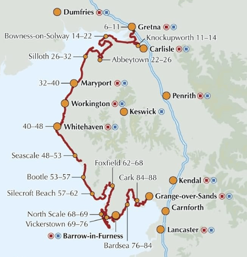
Productomschrijving: This map booklet to the Cumbrian section of the England Coast Path contains detailed mapping for walking the route in either direction. With easy access at many points along the way, the Cumbrian section can be enjoyed as a trek of around 15 days or in shorter sections.
- Full route shown on 1:25,000 OS maps
- Map booklet can be used to walk the path in either direction
- Covers the England Coast Path from Gretna on the Scottish border to Grange-over-Sands
- Conveniently sized for slipping into a jacket pocket or top of a rucksack
- An accompanying Cicerone guidebook - Walking the England Coast Path: North West - is available separately
Gekoppelde artikelen

Wandelgids King Charles III England Coast Path - Cicerone • 9781786310279
standaard versieKing Charles III England Coast Path - Cicerone Productomschrijving: A guidebook to walking the northwest section of the King Charles III England Coast Path between Gretna and Chester. Covering 590km (367 miles), this straightforward trail along the Cumbria, Lancashire and Merseyside coast takes around 1 month to hike. The route is described from north to south in 28 stages between 13 a…

Wandelgids King Charles III England Coast Path Map Booklet • 9781786310415
standaard versieKing Charles III England Coast Path Map Booklet - Cicerone Productomschrijving: This map booklet to the Lancashire and Merseyside section of the England Coast Path contains detailed mapping for walking the route in either direction. With easy access at many points along the way, the Lancashire/Merseyside section can be enjoyed as a trek of around 12 days or in shorter sections. - Full…
Artikelen uit dezelfde regio

Wandelgids 060 Pathfinder guides Lake District NP - OS • 9780319090169
Wandelgids Lake District NP - OS Productomschrijving: The Pathfinder Guide for the Lake District NP is the ideal companion to gaining an appreciation of England's most mountainous region with its balanced range of walks across the whole of the National Park. There are a total of 28 outstanding circular walks in the Lake District National Park from 3 to 10 miles with easy-to-follow route de…
Mountainbikegids Lake District Mountain Biking - Vertebrate Publ. • 9781839810732
Lake District Mountain Biking - Vertebrate Productomschrijving: Essential Trails is the fully updated third edition of Vertebrate Publishing's bestselling mountain bike guide to the Lake District National Park. It includes rides around Grizedale, High Street and Borrowdale, and much more, and features industry-standard Ordnance Survey mapping, and is illustrated with action photography. …

Wandelkaart Lake District West - XT40 ultra - Harvey Maps • 9781851377190
Wandelkaart Lake District West - Harvey Maps Productomschrijving: Omvat een groot gebied maar is praktisch en compact, zakformaat - Gedetailleerde kaart voor lopers en wandelaars van de westelijke heuvels van het Lake District National Park. - Scafell en de Langdale Pikes, en fells ten westen van de Kendal-Keswick-weg. - Hard Knott en Wrynose passen. Ennerdale, Wast Water en Conist…
Mountainbike kaart Lake District NP - Goldeneye • 9781859653005
MTB kaart Lake District NP - Goldeneye Productomschrijving: The routes are graded with approximate time & mileage. Unsurprisingly, the mountainous landscape of the Lake District has some of the toughest mountain biking in the UK and, on major routes crossing the steep sided ridges between major valleys, long pushes or carries are inescapable - even for the fittest. This is only one asp…

Fietsgids Gravel Rides Lake District - Vertebrate Publ. • 9781839811845
Gravel Rides Lake District - Vertebrate Productomschrijving: 15 gravel bike adventures in Cumbria Gravel Rides Lake District by Andrew Barlow showcases 15 of the best gravel bike rides in the stunning Lake District National Park. Researched, ridden and written by Lakes local Andrew Barlow, the routes feature clear and easy-to-use Ordnance Survey 1:50,000 maps; easy-to-follow directions…