
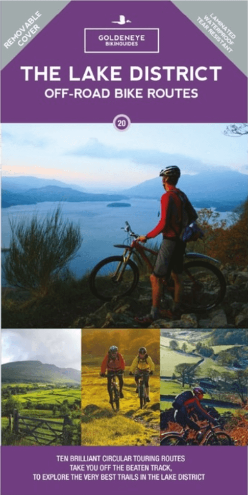
Mountainbike kaart Lake District NP - Goldeneye
The Keswick Railway Path & Castlerigg Stone Circle
Korte omschrijving
Fietskaarten Cumbria & Lake District, England van Goldeneye. Ideaal voor tochten in England.
MTB kaart Lake District NP - Goldeneye Productomschrijving: The routes are graded with approximate time & mileage. Unsurprisingly, the mountainous landscape of the Lake District has some...

Specificaties
- Uitgever: Goldeneye
- ISBN-13: 9781859653005
- HOOFDCATEGORIEËN: Fietskaart
- Regio: Cumbria & Lake District, England
- Land: England
- Nationale parken: Lake District NP, Cumbria England
- Schaal: 1:37700
- Editie: 4
- Taal: Engels
- De Engelse Graafschappen: Cumberland (Cumbria)
- De Nationale Parken: Lake district National Park, England
- VTT / MTB: Mountainbike
Volledige omschrijving
MTB kaart Lake District NP - Goldeneye
Productomschrijving: The routes are graded with approximate time & mileage.
Unsurprisingly, the mountainous landscape of the Lake District has some of the toughest mountain biking in the UK and, on major routes crossing the steep sided ridges between major valleys, long pushes or carries are inescapable - even for the fittest. This is only one aspect of the Lake District.
As well as the mountains, you are never far from streams, lakes, ancient forests, rolling pastures and farm buildings. The variety of scenery and terrain is impressive and great for off-roading. There are plenty of challenging climbs and fast descents to get the adrenaline buzzing - though some are quite rough - and you will often feel remote and cut off from the world.
The routes are graded: easy, moderate and more strenuous although none are what could be called hard core mountain bike routes.
These routes include:
1. The Skiddaw Round.
2. Around Blencathra.
3. The Keswick Railway Path & Castlerigg Stone Circle.
4. Threlkeld, Troutbeck & The Old Coach Road.
5. Loweswater Circuit & Buttermere Circuit.
6. Watendlath - Honister Circuit.
7. Pooley Bridge - Askham Fell.
8. Eskdale.
9. Coniston - Walna Scar Road-Broughton Moor (& Banishead Quarries - Torver).
10. Windermere - Kentmere & The Garburn Pass.
Artikelen uit dezelfde regio

Wandelgids King Charles III England Coast Path Map Booklet • 9781786310293
Wandelgids King Charles III England Coast Path Map Booklet Productomschrijving: This map booklet to the Cumbrian section of the England Coast Path contains detailed mapping for walking the route in either direction. With easy access at many points along the way, the Cumbrian section can be enjoyed as a trek of around 15 days or in shorter sections. - Full route shown on 1:25,000 OS map…

Wandelkaart Lake District South-East XT40 - Harvey Maps • 9781851376667
Wandelkaart Lake District Zuid-Oost XT40 - Harvey Maps Productomschrijving: Omvat een groot gebied maar is praktisch en compact, zakformaat. Gedetailleerde kaart voor lopers en wandelaars van de zuidoostelijke heuvels van het Lake District National Park. Op de kaart staat Lake Windermere in het midden. Inclusief Ambleside, Coniston en Kendal en het uitstekende mountainbikegebied van G…

Wandelgids 086 Pathfinder guides Lake District and Cumbria - OS • 9780319092569
Wandelgids Lake District and Cumbria - OS Productomschrijving: 122 miles of thrilling Hebridean walking across ten stunning isles, from the Butt of Lewis in the north to Vatersay in the south. Discover crafting heritage, the ancient Callanish Standing Stones and the impressive broch of Dùn Carloway; delight in the variety of birdlife at Balranald and wooded Arinaban; enjoy miles of silver…

Wandelgids Lake District Low level & lake walks - Cicerone • 9781786312273
Lake District NP Low level & lake walks - Cicerone Productomschrijving: This guidebook describes 30 of the best low-level walks in the Lake District. From delightful wooded glades and sparkling tarns, to waterfalls and glacier-carved valleys towered over by craggy mountains. The walks described aim to seek out the best walking that the lower areas of the Lake District have to offer. Se…

Wandelkaart 90 Lake Distrist NP - Penrith & Keswick - OSI • 9780319475393
Lake Distrist NP - Penrith & Keswick - OSI Productomschrijving: Kaart nummer 90 in de OS Landranger kaartenserie is de perfecte kaart voor het plannen van vakanties en dagtochten naar het Penrith en Keswick gebied van het Lake District. Het gebied is ideaal voor vakantiegangers die willen deelnemen aan wandelingen, tochten of watersporten, want er zijn fantastische paden, activiteiten en l…