

HOOFDCATEGORIEËN
Activiteiten
De beroemdste Eilandengroepen
Iconische Bergketens van Europa
AONB - Area of Outstanding Beauty/National Landscape
TOPO's & Stafkaarten
Nationale parken
Regionale parken
UNESCO werelderfgoed
Waterafstotende kaart
Grote Eilanden
Continent
Land
Regio
Reeks/Serie:
Uitgever

Ordnance Survey
Ordnance Survey, Topografische Perfectie van de Britse Eilanden!
Ordnance Survey is het nationale cartografische agentschap van het Verenigd Koninkrijk en wordt wereldwijd erkend als een toonaangevende uitgever van Topografische kaarten. Met een geschiedenis die teruggaat tot 1791, biedt Ordnance Survey kaarten van ongeëvenaarde nauwkeurigheid en kwaliteit. Hun kaarten zijn essentieel voor wandelaars, fietsers en outdoorliefhebbers die het Britse landschap willen verkennen.
De kaarten van Ordnance Survey bestrijken het volledige Verenigd Koninkrijk en bieden een uitzonderlijk detailniveau. Ze zijn ontworpen met een focus op topografie en bevatten essentiële informatie zoals hoogtelijnen, terreincontouren, wandelpaden, natuurlijke kenmerken en culturele bezienswaardigheden. De precisie en betrouwbaarheid van OS-kaarten maken ze een favoriet bij zowel recreatieve als professionele gebruikers.
Ordnance Survey biedt verschillende reeksen kaarten die zijn afgestemd op specifieke behoeften. De Explorer-reeks, met een schaal van 1:25.000, is ideaal voor wandelaars en biedt een ongekend detailniveau, inclusief lokale paden en markante punten. De Landranger-reeks, op een schaal van 1:50.000, biedt een breder overzicht, geschikt voor langeafstandswandelingen en routeplanning. Voor digitale gebruikers biedt OS ook een scala aan interactieve kaarten en apps die toegang bieden tot actuele en gedetailleerde kaartinformatie.
Naast traditionele papieren kaarten staat Ordnance Survey bekend om hun innovatieve gebruik van technologie, zoals GPS-compatibiliteit en digitale overlays. Deze combinatie van traditie en innovatie maakt Ordnance Survey dé betrouwbare partner voor iedereen die het gevarieerde en indrukwekkende Britse landschap wil ontdekken. Met Ordnance Survey navigeren avonturiers met vertrouwen en precisie.


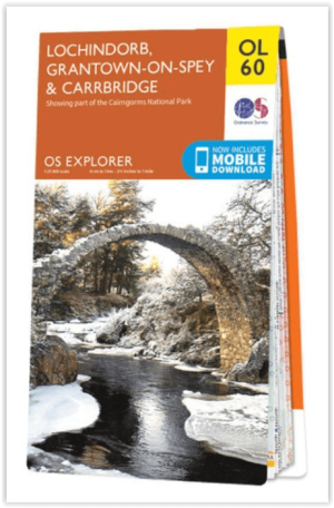
Wandelkaart OL60 Lochindorb & Grantown-on-Spey - OS • 9780319242995
Wandelkaart Lochindorb & Grantown-on-Spey - OS Productomschrijving: Een topografische wandelkaart van een deel van de Cairngorms National park. Omvat: Lochindorb & Grantown-on-Spey, The Speyside Way, The Dava Way. Ontdek de OL-serie van Ordnance Survey: De OL-serie (Outdoor Leisure) van Ordnance Survey is dé referentie voor wie gaat wandelen op de Britse eilanden. Deze topografi…
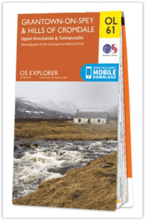
Wandelkaart OL61 Grantown-on-Spey & Hills Cromdale - OS • 9780319243008
Wandelkaart Grantown-on-Spey & Hills Cromdale - OS Productomschrijving: Een topografische wandelkaart van een deel van de Cairngorms National park. Omvat: Grantown-on-Spey, Hills Cromdale, Upper Knockando & Tomnavoulin, The Speyside Way & Dava Way, Ontdek de OL-serie van Ordnance Survey: De OL-serie (Outdoor Leisure) van Ordnance Survey is dé referentie voor wie gaat wandelen op…

Wandelkaart OL62 Correen Hills, Glenlivet & Bennachie - OS • 9780319243015
Wandelkaart Correen Hills, Glenlivet & Bennachie - OS Ladder Hills Insch & Rhynie Productomschrijving: Een topografische wandelkaart van een deel van de Cairngorms National park. Omvat: Correen Hills, Glenlivet, Bennachie, Ladder Hills Insch & Rhynie, The Gordon Way Ontdek de OL-serie van Ordnance Survey: De OL-serie (Outdoor Leisure) van Ordnance Survey is dé referentie voor …

Wandelkaart OL30 Yorkshire Dales - Northern & Central areas - OS • 9780319263358
Wandelkaart Yorkshire Dales - Northern & Central areas - OS Productomschrijving: Een topografische wandelkaart van het Noordelijke & centrale gedeelte van het Yorkshire Dales Nationaal Park. Omvat: Wensleydale & Swaledale, northern & Central areas of Yorkshire Dales National Park, with The Nidderdale & Northern Pennines AONB area's, A Pennine Journey, the Dales Way, E2 European Long di…
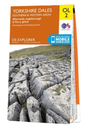
Wandelkaart OL02 Yorkshire Dales - South& Western areas - OS • 9780319263310
Wandelkaart OL2 Yorkshire Dales - South& Western areas - OS Productomschrijving: Yorkshire Dales Nationale Park - South& Western areas, Whernside, Ingleborough & Pen-y-ghent, The AONB Area's of Forest of Bowland & Nidderdale AONB. Yorkshire three peaks, The Devils Bridge at Kirkby Lonsdale, Leeds to Liverpool Canal at Skipton, The Pennine Way, Settle, and Old Town. Omvat: Whernside, I…
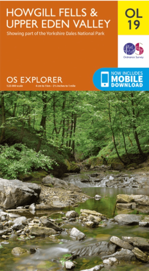
Wandelkaart OL19 Howgill Fells & Upper Eden Valley - OS • 9780319263341
Wandelkaart Howgill Fells & Upper Eden Valley - OS Productomschrijving: Topografische wandelkaart van The Howgill Fells & The Upper Eden Valley, dat deels in het Lake Distrisct National Park ligt. Omvat: Howgill Fells & Upper Eden Valley, parts of the Yorkshire Dales National Park en The Lake Distrisct National Park, The Pennine Journey, Dales High Way, Dales Way, E2 European Long D…
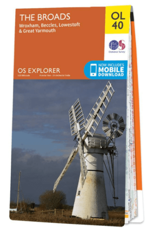
Wandelkaart OL40 The Broads National Park - OS • 9780319263549
Wandelkaart The Broads National Park - OS Productomschrijving: The Broads National Park, Wroxham, Beccles, Lowestoft and Great Yarmouth. Omvat: Wroxham, Beccles, Lowestoft and Great Yarmouth Ontdek de OL-serie van Ordnance Survey: De OL-serie (Outdoor Leisure) van Ordnance Survey is dé referentie voor wie gaat wandelen op de Britse eilanden. Deze topografische kaarten maken deel …

Wandelgids 100 outstanding British Walks - Ordnance Survey • 9780319090862
100 outstanding British Walks - OS Productomschrijving: Deze gloednieuwe wandelgids van Ordnance Survey, brengt u een hoop prachtige wandelingen over het ganse Britse landschap verdeeld. Onderaan vindt u de lijst, opgedeeld in de verschillende regio's van de Britse eilanden. Engelse omschrijving: This magnificent compendium of outstanding British walks brings together the finest sele…
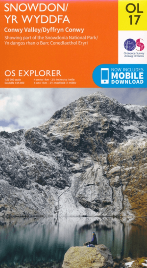
Wandelkaart OL017 Snowdon- Conwy Valley & Dyffryn Conwy - OS • 9780319263532
Wandelkaart Snowdon- Conwy Valley & Dyffryn Conwy - OS Productomschrijving: Een topografische wandelkaart van deels van het Nationaal park van Snowdonia in Gwynedd, Wales. Omvat: Snowdon- Conwy Valley & Dyffryn Conwy, & parts of Snowdonia National Park. Ontdek de OL-serie van Ordnance Survey: De OL-serie (Outdoor Leisure) van Ordnance Survey is dé referentie voor wie gaat wandele…

Wandelkaart OL018 Harlech- Porthmadog & Y Bala - OS • 9780319263587
Wandelkaart Harlech- Porthmadog & Y Bala - OS Productomschrijving: Harlech- Porthmadog & Y Bala, Gwynedd Wales UK. Omvat: Harlech- Porthmadog & Y Bala & parts of Snowdonia National Park Ontdek de OL-serie van Ordnance Survey: De OL-serie (Outdoor Leisure) van Ordnance Survey is dé referentie voor wie gaat wandelen op de Britse eilanden. Deze topografische kaarten maken deel uit v…

Wandelkaart OL023 Cadair Idris & Llyn Tegid - OS • 9780319263594
Wandelkaart Cadair Idris & Llyn Tegid - OS Productomschrijving: Een topografische wandelkaart van een deel van het Snowdonia National park en omgeving. Omvat: Cadair Idris & Llyn Tegid, and parts of Snowdonia National Park Ontdek de OL-serie van Ordnance Survey: De OL-serie (Outdoor Leisure) van Ordnance Survey is dé referentie voor wie gaat wandelen op de Britse eilanden. Deze t…
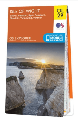
Wandelkaart OL29 Isle of Wight South East England - OS • 9780319263631
Wandelkaart Isle of Wight - OS Productomschrijving: Isle of Wight South East England, Isle of Whight AONB, New Forest National Park, Allan King Way, Bembridge Trail, Coastal Path, E9 European Long Distance Trail, Freshwater Way, Hamstead Trail, Nunwell Trail, Pilgrim's Trail, Shepherds Trail, Shipwrights Way, Solent Way, Stenbury Trail, Tennyson Trail, Worsley Trail & Yar River Trail. …

Wandelkaart OL01 Peak District NP & Dark Peak area - OS • 9780319263655
Wandelkaart Peak District NP & Dark Peak area - OS Productomschrijving: Peak District National Park & Dark Peak area, Derbyshire England. Omvat: Parts of Peak districh National & Dark peak Area, Kinder Scout, Bleaklow, Black Hill & Ladybower Reservoir. Ontdek de OL-serie van Ordnance Survey: De OL-serie (Outdoor Leisure) van Ordnance Survey is dé referentie voor wie gaat wandele…
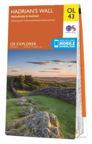
Wandelkaart OL43 Hadrian's Wall- Haltwhistle & Hexham - OS • 9780319263624
Wandelkaart Hadrian's Wall- Haltwhistle & Hexham - OS Productomschrijving: Topografische wandelkaart van Hadrian's Wall- Haltwhistle & Hexham. Omvat: Haltwhistle & Hexham, historic Hadrian's Wall path across Northern England, with parts of Northumberland National park & The Pennine Way. Ontdek de OL-serie van Ordnance Survey: De OL-serie (Outdoor Leisure) van Ordnance Survey is …
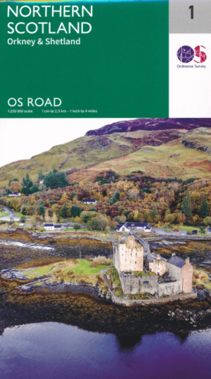
Landkaart Wegenkaart 1 Schotland Noord - OSI • 9780319263730
Wegenkaart Schotland Noord - OSI Productomschrijving: Plan your journey with this series of road maps from OS. Showing all major roads, rail and ferry links as well as settlements and selected features in 1: 250 000 scale, this is the ideal map for planning trips and holidays by car or cycle. OS Road 1 covers North-East Scotland, Orkney and Shetland (shown in 1: 400 000 scale).

Landkaart Wegenkaart 2 Schotland West & Western Isles - OSI • 9780319263747
Wegenkaart Schotland West & Western Isles - OSI Productomschrijving: Plan your journey with this series of road maps from OS. Showing all major road, rail and ferry links as well as settlements and selected features in 1: 250 000 scale, this is the ideal map for planning trips and holidays by car or cycle. OS Road 2 covers: Scotland's west coast, including the Western Isles (Hebrides)…

Landkaart Wegenkaart 3 Schotland Zuid & Northumberland - OSI • 9780319263754
Wegenkaart Schotland Zuid & Northumberland - OSI Productomschrijving: Plan your journey with this series of road maps from OS. Showing all major road, rail and ferry links as well as settlements and selected features in 1: 250 000 scale, this is the ideal map for planning trips and holidays by car or cycle. OS Road 3 covers: Southern Scotland plus Northumberland in the North of Englan…
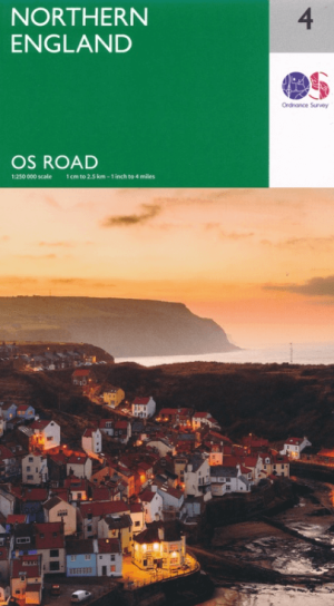
Landkaart Wegenkaart 4 Engeland Noord - OSI • 9780319263761
Wegenkaart Noord Engeland - OSI Productomschrijving: Plan your journey with this series of road maps from OS. Showing all major road, rail and ferry links as well as settlements and selected features in 1: 250 000 scale, this is the ideal map for planning trips and holidays by car or cycle. OS Road 4 covers: Northern England, including the Lake District, North York Moors Liverpool and…

Landkaart Wegenkaart 5 Midlands Oost & East Anglia - OSI • 9780319263778
Wegenkaart Midlands Oost & East Anglia - OSI Productomschrijving: Plan your journey with this series of road maps from OS. Showing all major road, rail and ferry links as well as settlements and selected features in 1: 250 000 scale, this is the ideal map for planning trips and holidays by car or cycle. OS Road 5 covers: the East Midlands, including the Norfolk and the Thames Estuary.…

Landkaart Wegenkaart 6 Wales & Midlands West - OSI • 9780319263785
Wegenkaart Wales & Midlands West - OSI Productomschrijving: Plan your journey with this series of road maps from OS. Showing all major road, rail and ferry links as well as settlements and selected features in 1: 250 000 scale, this is the ideal map for planning trips and holidays by car or cycle. OS Road 6 covers: the Wales plus the West Midlands.

Landkaart Wegenkaart 7 Zuidwest Engeland & Zuid Wales - OSI • 9780319263792
Wegenkaart Zuidwest Engeland & Zuid Wales - OSI Productomschrijving: Plan your journey with this series of road maps from OS. Showing all major road, rail and ferry links as well as settlements and selected features in 1: 250 000 scale, this is the ideal map for planning trips and holidays by car or cycle. OS Road 7 covers: the south-west England plus south Wales, Devon & Cornwall. …

Landkaart Wegenkaart 8 Zuidoost Engeland - OSI • 9780319263808
Wegenkaart Zuidoost Engeland - OSI Productomschrijving: Plan your journey with this series of road maps from OS. Showing all major road, rail and ferry links as well as settlements and selected features in 1: 250 000 scale, this is the ideal map for planning trips and holidays by car or cycle. OS Road 8 covers: the south-east England.

Wandelkaartv OL14 Wye Valley, Forest of Dean & Dyfryn Gwy - OS • 9780319263839
Wandelkaartv Wye Valley, Forest of Dean & Dyfryn Gwy - OS Productomschrijving: Parts of Offa's Dyke Path, on the border of England & Wales. Omvat: Wye Valley, Forest of Dean & Dyfryn Gwy, Wye Valley AONB, Daffodil Way, Gloucestershire Way, Herefordshire Way, Jubilee Way, Offa's Dyke Path, Severn Way, Thames & Severn Way, Three Coastal Walk, Wales Coast Path, Wye Valley Walk & Wysis Way…

Wandelkaart OL24 Peak District & White Peak area - OS • 9780319263846
Wandelkaart Peak District & White Peak area - OS Productomschrijving: Peak District & White Peak area, Derbyshire England Omvat: Buxton, Bakewell, Matlock & Dove Dale, with parts of the Peak district National Park. Ontdek de OL-serie van Ordnance Survey: De OL-serie (Outdoor Leisure) van Ordnance Survey is dé referentie voor wie gaat wandelen op de Britse eilanden. Deze topograf…
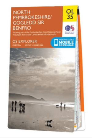
Wandelkaart OL035 Pembrokeshire National Park North - OS • 9780319263938
Wandelkaart Pembrokeshire National Park North - OS Productomschrijving: Pembrokeshire National Park North - Gogledd Sir Benfro Omvat: Showing part of the Pembrokeshire Coastt National Park. Ontdek de OL-serie van Ordnance Survey: De OL-serie (Outdoor Leisure) van Ordnance Survey is dé referentie voor wie gaat wandelen op de Britse eilanden. Deze topografische kaarten maken deel …